Property Record
4225 Power Inn Rd, Sacramento, CA 95826
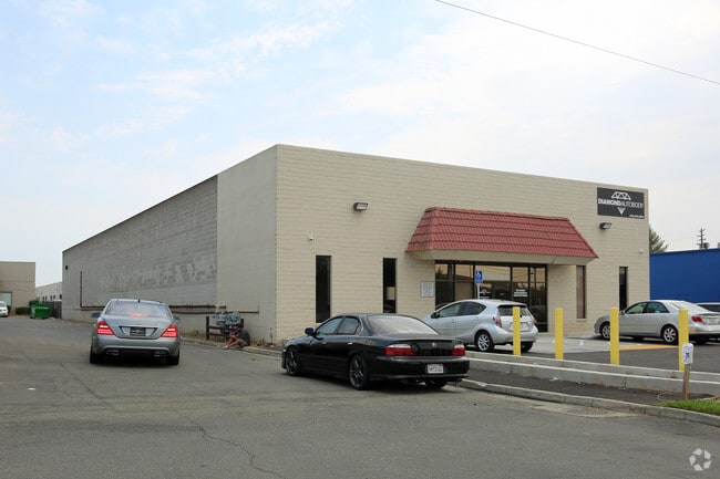

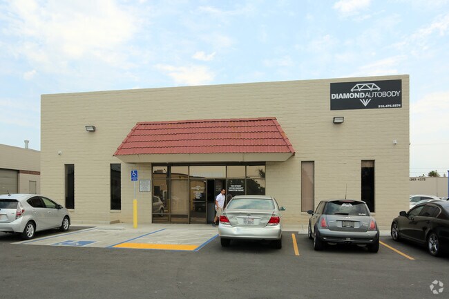
Property Detail
4225 Power Inn Rd
Sacramento-Roseville-Folsom, CA
NORTH75.08 FT LOT30
061-0061-032
Sacramento
Warehouse
California
M-1S-SWR
29,30
2024
2.68 AC
2025
Power Inn
005205
Sacramento
36,800 SF
NEARBY LISTINGS FOR SALE OR LEASE
DEMOGRAPHICS near 4225 Power Inn Rd
1 mile
3 mile
5 mile
2025 Total Population
9,595
134,824
384,331
2030 Population
9,654
136,762
390,056
Pop Growth 2025-2030
+ 0.61%
+ 1.44%
+ 1.49%
Average Age
38
38
39
2025 Total Households
3,367
49,676
145,055
HH Growth 2025-2030
+ 0.56%
+ 1.53%
+ 1.62%
Median Household Inc
$76,455
$76,027
$79,081
Avg Household Size
2.60
2.50
2.50
2025 Avg HH Vehicles
2.00
2.00
2.00
Median Home Value
$375,308
$463,155
$476,011
Median Year Built
1963
1968
1970
Nearby Places
Map Layers
Map Styles
 Street
 Aerial
Layers
 Traffic
 Biking
Places
Listings with unknown addresses are not visible on the map
- Restaurants
- Banks
- Shops
- Fitness
- Groceries
PUBLIC TRANSPORTATION
COMMUTER RAIL
Drive
Walk
Distance
13 min
8.3 mi
AIRPORT
Sacramento International
Drive
Walk
Distance
Sacramento International
27 min
18.6 mi
Freight Ports
Port of Stockton
Drive
Walk
Distance
Port of Stockton
61 min
48.4 mi
Nearby Properties
Address
Land Use
TOTAL SIZE
Lot Size
Zoning
Address
Land Use
TOTAL SIZE
Lot Size
Zoning
7,742 SF
12.66 AC
M-1S-SWR
Address
Land Use
TOTAL SIZE
Lot Size
Zoning
299,943 SF
4.95 AC
H
Address
Land Use
TOTAL SIZE
Lot Size
Zoning
1.33 AC
R-1
Address
Land Use
TOTAL SIZE
Lot Size
Zoning
2,317,288 SF
220.58 AC
M-2-SPD
Address
Land Use
TOTAL SIZE
Lot Size
Zoning
9.29 AC
R-1 OB-R-P
Address
Land Use
TOTAL SIZE
Lot Size
Zoning
1.15 AC
R-1
Address
Land Use
TOTAL SIZE
Lot Size
Zoning
31,163 SF
1.57 AC
C-2-TO-SPD
Address
Land Use
TOTAL SIZE
Lot Size
Zoning
350,049 SF
8.51 AC
MRD-SWR
Address
Land Use
TOTAL SIZE
Lot Size
Zoning
45.93 AC
M-2S
Address
Land Use
TOTAL SIZE
Lot Size
Zoning
281,448 SF
13.42 AC
RMX-TO R-2
Address
Land Use
TOTAL SIZE
Lot Size
Zoning
149,566 SF
9.68 AC
M-2S
Address
Land Use
TOTAL SIZE
Lot Size
Zoning
179,178 SF
3.35 AC
RO
Address
Land Use
TOTAL SIZE
Lot Size
Zoning
2.59 AC
OB-R
Address
Land Use
TOTAL SIZE
Lot Size
Zoning
119,380 SF
18.92 AC
M-2S
Address
Land Use
TOTAL SIZE
Lot Size
Zoning
1.15 AC
R-1
Address
Land Use
TOTAL SIZE
Lot Size
Zoning
156,462 SF
8.36 AC
R-3
Address
Land Use
TOTAL SIZE
Lot Size
Zoning
40.67 AC
M-2-SPD
Address
Land Use
TOTAL SIZE
Lot Size
Zoning
584,820 SF
29.12 AC
M-2S
Address
Land Use
TOTAL SIZE
Lot Size
Zoning
345,600 SF
14.84 AC
M-1S-SWR
Address
Land Use
TOTAL SIZE
Lot Size
Zoning
164,981 SF
3.95 AC
OB-SWR-PUD
Address
Land Use
TOTAL SIZE
Lot Size
Zoning
53,386 SF
7.75 AC
C-2-SPD
Address
Land Use
TOTAL SIZE
Lot Size
Zoning
171,405 SF
13.80 AC
R-1
Address
Land Use
TOTAL SIZE
Lot Size
Zoning
192,308 SF
5.42 AC
C-2
Address
Land Use
TOTAL SIZE
Lot Size
Zoning
303,950 SF
19.34 AC
R-2A-R
Address
Land Use
TOTAL SIZE
Lot Size
Zoning
82,936 SF
7.66 AC
SC-PUD
Address
Land Use
TOTAL SIZE
Lot Size
Zoning
128,950 SF
0.75 AC
RMX-TO-SPD
Address
Land Use
TOTAL SIZE
Lot Size
Zoning
137,520 SF
10.37 AC
BP (PC)(PD
Address
Land Use
TOTAL SIZE
Lot Size
Zoning
261,350 SF
14.41 AC
M-2S
Address
Land Use
TOTAL SIZE
Lot Size
Zoning
81,504 SF
7.06 AC
LC (PC) RD
Address
Land Use
TOTAL SIZE
Lot Size
Zoning
387,136 SF
8.85 AC
RD-30
The World's #1 Commercial Real Estate Marketplace
Connect with us
© 2026 CoStar Group
The information above has been obtained from sources believed reliable. While we do not doubt its accuracy we have not verified it and make no guarantee, warranty or representation about it. It is your responsibility to independently confirm its accuracy and completeness. Any projections, opinions, assumptions, or estimates used are for example only and do not represent the current or future performance of the property. The value of this transaction to you depends on tax and other factors which should be evaluated by your tax, financial, and legal advisors. You and your advisors should conduct a careful, independent investigation of the property to determine to your satisfaction the suitability of the property for your needs.