Property Record
2201 W Ramada Ln, Carbondale, IL 62901
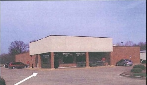

Property Detail
2201 W Ramada Ln
Carbondale, IL
LOT 1 B NEW ERA PLAZA II 17-9-1 1.22 ACRES P.C. 2 S1 19 936/897 2006/22594
15-17-351-013
Jackson
Commercialnec
Illinois
AE The base floodplain where base flood elevations are provided. AE Zones are now used on new format FIRMs instead of A1-A30 Zones.
1
2024
1.22 AC
2024
Marion/I-64 & South
010800
Other Market Areas
2,312 SF
NEARBY LISTINGS FOR SALE OR LEASE
-
-
View all Carbondale listings for sale on LoopNet.com
DEMOGRAPHICS near 2201 W Ramada Ln
1 mile
3 mile
5 mile
2025 Total Population
4,168
22,890
30,245
2030 Population
4,142
23,211
30,595
Pop Growth 2025-2030
(0.62%)
+ 1.40%
+ 1.16%
Average Age
43
35
36
2025 Total Households
1,922
9,999
13,331
HH Growth 2025-2030
(0.62%)
+ 1.40%
+ 1.15%
Median Household Inc
$63,244
$33,544
$36,593
Avg Household Size
2.00
1.90
2.00
2025 Avg HH Vehicles
2.00
1.00
1.00
Median Home Value
$150,925
$145,803
$149,559
Median Year Built
1975
1977
1978
Nearby Places
Map Layers
Map Styles
 Street
 Aerial
Layers
 Traffic
 Biking
Places
Listings with unknown addresses are not visible on the map
- Restaurants
- Banks
- Shops
- Fitness
- Groceries
PUBLIC TRANSPORTATION
COMMUTER RAIL
Drive
Walk
Distance
5 min
2.1 mi
Nearby Properties
Address
Land Use
TOTAL SIZE
Lot Size
Zoning
Address
Land Use
TOTAL SIZE
Lot Size
Zoning
Address
Land Use
TOTAL SIZE
Lot Size
Zoning
32,610 SF
27.03 AC
Address
Land Use
TOTAL SIZE
Lot Size
Zoning
16.78 AC
Address
Land Use
TOTAL SIZE
Lot Size
Zoning
9,360 SF
1.56 AC
Address
Land Use
TOTAL SIZE
Lot Size
Zoning
17.78 AC
Address
Land Use
TOTAL SIZE
Lot Size
Zoning
17,820 SF
9 AC
Address
Land Use
TOTAL SIZE
Lot Size
Zoning
24,936 SF
3.76 AC
Address
Land Use
TOTAL SIZE
Lot Size
Zoning
8.67 AC
Address
Land Use
TOTAL SIZE
Lot Size
Zoning
119,175 SF
2.84 AC
Address
Land Use
TOTAL SIZE
Lot Size
Zoning
18.41 AC
Address
Land Use
TOTAL SIZE
Lot Size
Zoning
79,800 SF
2.50 AC
Address
Land Use
TOTAL SIZE
Lot Size
Zoning
Address
Land Use
TOTAL SIZE
Lot Size
Zoning
10.15 AC
Address
Land Use
TOTAL SIZE
Lot Size
Zoning
13,440 SF
0.83 AC
Address
Land Use
TOTAL SIZE
Lot Size
Zoning
1.21 AC
Address
Land Use
TOTAL SIZE
Lot Size
Zoning
3,072 SF
1.89 AC
Address
Land Use
TOTAL SIZE
Lot Size
Zoning
0.85 AC
Address
Land Use
TOTAL SIZE
Lot Size
Zoning
84,810 SF
7.50 AC
Address
Land Use
TOTAL SIZE
Lot Size
Zoning
4,080 SF
0.85 AC
Address
Land Use
TOTAL SIZE
Lot Size
Zoning
5,532 SF
7.93 AC
Address
Land Use
TOTAL SIZE
Lot Size
Zoning
0.35 AC
Address
Land Use
TOTAL SIZE
Lot Size
Zoning
4.66 AC
Address
Land Use
TOTAL SIZE
Lot Size
Zoning
Address
Land Use
TOTAL SIZE
Lot Size
Zoning
4,400 SF
3.03 AC
Address
Land Use
TOTAL SIZE
Lot Size
Zoning
2.03 AC
Address
Land Use
TOTAL SIZE
Lot Size
Zoning
1.86 AC
The World's #1 Commercial Real Estate Marketplace
Connect with us
© 2026 CoStar Group
The information above has been obtained from sources believed reliable. While we do not doubt its accuracy we have not verified it and make no guarantee, warranty or representation about it. It is your responsibility to independently confirm its accuracy and completeness. Any projections, opinions, assumptions, or estimates used are for example only and do not represent the current or future performance of the property. The value of this transaction to you depends on tax and other factors which should be evaluated by your tax, financial, and legal advisors. You and your advisors should conduct a careful, independent investigation of the property to determine to your satisfaction the suitability of the property for your needs.