Property Record
6251 Ammendale Rd, Beltsville, MD 20705

NEARBY LISTINGS FOR SALE OR LEASE
Property Detail
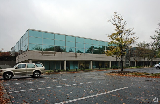
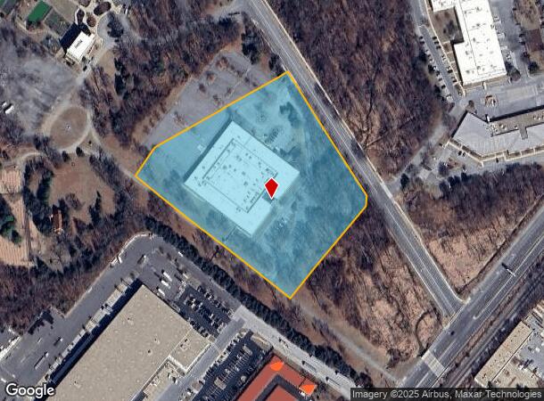
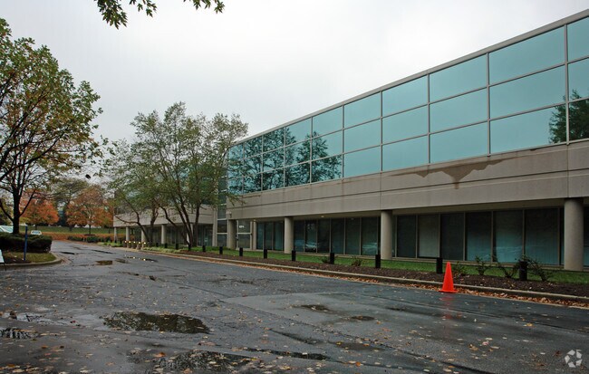
6251 Ammendale Rd
Washington-Arlington-Alexandria, DC-VA-MD-WV
Plat 1 Ammendale Business Campus South
01-0000984
PARCEL A
Officebuilding
Prince George's
AE
Maryland
24033C0042E
a
2024
7.36 AC
2025
Beltsville/Calverton
807404
Washington, DC
91,050 SF
DEMOGRAPHICS near 6251 Ammendale Rd
1 Mile
3 Mile
5 Mile
2024 Total Population
5,558
71,507
231,480
2029 Population
5,392
70,200
226,837
Pop Growth 2024-2029
(2.99%)
(1.83%)
(2.01%)
Average Age
40
41
38
2024 Total Households
1,622
26,689
82,865
HH Growth 2024-2029
(2.96%)
(1.76%)
(2.14%)
Median Household Inc
$98,136
$93,433
$86,864
Avg Household Size
3.30
2.60
2.60
2024 Avg HH Vehicles
2.00
2.00
2.00
Median Home Value
$370,720
$401,953
$401,324
Median Year Built
1975
1986
1980
Nearby Places
- Restaurants
- Banks
- Shops
- Fitness
- Groceries
PUBLIC TRANSPORTATION
COMMUTER RAIL
Muirkirk (CAMDEN - WASHINGTON - Maryland Area Regional Commuter Trains (The MARC), Camden Line - Maryland Area Regional Commuter Trains (The MARC))
DRIVE
WALK
Distance
Muirkirk (CAMDEN - WASHINGTON - Maryland Area Regional Commuter Trains (The MARC), Camden Line - Maryland Area Regional Commuter Trains (The MARC))
3 min
1.4 mi
Greenbelt (Green Line - Washington Metropolitan Area Transit Authority Metrorail (Metrorail))
DRIVE
WALK
Distance
Greenbelt (Green Line - Washington Metropolitan Area Transit Authority Metrorail (Metrorail))
9 min
4.5 mi
AIRPORT
Ronald Reagan Washington Ntl
DRIVE
WALK
Distance
Ronald Reagan Washington Ntl
36 min
21.4 mi
Baltimore/Washington International Thurgood Marshall
DRIVE
WALK
Distance
Baltimore/Washington International Thurgood Marshall
31 min
23.4 mi
Freight Ports
Port of Baltimore
DRIVE
WALK
Distance
Port of Baltimore
36 min
26.3 mi
Nearby Properties
Address
Land Use
TOTAL SIZE
Lot Size
Zoning
Address
Land Use
TOTAL SIZE
Lot Size
Zoning
1,244,733 SF
38.03 AC
RE2
Address
Land Use
TOTAL SIZE
Lot Size
Zoning
393,970 SF
44 AC
RR
Address
Land Use
TOTAL SIZE
Lot Size
Zoning
1,146,407 SF
60.25 AC
AG
Address
Land Use
TOTAL SIZE
Lot Size
Zoning
218,406 SF
26.80 AC
LAUR
Address
Land Use
TOTAL SIZE
Lot Size
Zoning
791,089 SF
10.69 AC
LAUR
Address
Land Use
TOTAL SIZE
Lot Size
Zoning
508 SF
7.27 AC
LTOE
Address
Land Use
TOTAL SIZE
Lot Size
Zoning
531,312 SF
25.70 AC
R30
Address
Land Use
TOTAL SIZE
Lot Size
Zoning
514,064 SF
7.37 AC
NAC
Address
Land Use
TOTAL SIZE
Lot Size
Zoning
390,986 SF
16.87 AC
LAUR
Address
Land Use
TOTAL SIZE
Lot Size
Zoning
564,165 SF
35.85 AC
RMF12
Address
Land Use
TOTAL SIZE
Lot Size
Zoning
15.90 AC
RTOLE
Address
Land Use
TOTAL SIZE
Lot Size
Zoning
559,944 SF
11.89 AC
IE
Address
Land Use
TOTAL SIZE
Lot Size
Zoning
104,067 SF
25.29 AC
RMF20
Address
Land Use
TOTAL SIZE
Lot Size
Zoning
482,799 SF
17.79 AC
R30
Address
Land Use
TOTAL SIZE
Lot Size
Zoning
2,240.90 AC
ROS
Address
Land Use
TOTAL SIZE
Lot Size
Zoning
285,116 SF
14.62 AC
AG
Address
Land Use
TOTAL SIZE
Lot Size
Zoning
769.33 AC
ROS
Address
Land Use
TOTAL SIZE
Lot Size
Zoning
158,316 SF
20.30 AC
LAUR
Address
Land Use
TOTAL SIZE
Lot Size
Zoning
39.59 AC
ROS
Address
Land Use
TOTAL SIZE
Lot Size
Zoning
598,096 SF
24.36 AC
NAC
Address
Land Use
TOTAL SIZE
Lot Size
Zoning
222,345 SF
14.21 AC
R30
Address
Land Use
TOTAL SIZE
Lot Size
Zoning
16.09 AC
RMF20
Address
Land Use
TOTAL SIZE
Lot Size
Zoning
394,180 SF
9.62 AC
LTOE
Address
Land Use
TOTAL SIZE
Lot Size
Zoning
235,616 SF
12.81 AC
R30
Address
Land Use
TOTAL SIZE
Lot Size
Zoning
15.70 AC
RMF20
Address
Land Use
TOTAL SIZE
Lot Size
Zoning
182,199 SF
43.70 AC
IE
Address
Land Use
TOTAL SIZE
Lot Size
Zoning
547.89 AC
ROS
Address
Land Use
TOTAL SIZE
Lot Size
Zoning
336,226 SF
21.50 AC
NAC
Address
Land Use
TOTAL SIZE
Lot Size
Zoning
11.01 AC
RMF20
Address
Land Use
TOTAL SIZE
Lot Size
Zoning
11.01 AC
RMF20
The World's #1 Commercial Real Estate Marketplace
Connect with us
© 2025 CoStar Group
The information above has been obtained from sources believed reliable. While we do not doubt its accuracy we have not verified it and make no guarantee, warranty or representation about it. It is your responsibility to independently confirm its accuracy and completeness. Any projections, opinions, assumptions, or estimates used are for example only and do not represent the current or future performance of the property. The value of this transaction to you depends on tax and other factors which should be evaluated by your tax, financial, and legal advisors. You and your advisors should conduct a careful, independent investigation of the property to determine to your satisfaction the suitability of the property for your needs.