Property Record
6544 Cincinnati Dayton Rd, Liberty Township, OH 45044


NEARBY LISTINGS FOR SALE OR LEASE
Property Detail
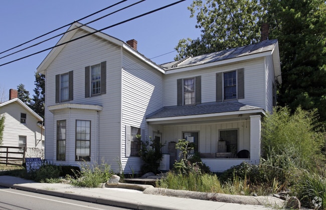
6544 Cincinnati Dayton Rd
Cincinnati, OH-KY-IN
Village/Bethany
D2030-050-000-018
2 ENT
Sfr
Butler
X
Ohio
39017C0240F
2
2024
0.31 AC
2025
Butler County
011120
Cincinnati/Dayton
2,061 SF
DEMOGRAPHICS near 6544 Cincinnati Dayton Rd
1 mile
3 mile
5 mile
2024 Total Population
3,632
49,913
128,324
2029 Population
3,624
51,314
132,753
Pop Growth 2024-2029
(0.22%)
+ 2.81%
+ 3.45%
Average Age
39
39
39
2024 Total Households
1,366
16,993
44,694
HH Growth 2024-2029
(0.37%)
+ 2.65%
+ 3.40%
Median Household Inc
$121,326
$129,545
$119,306
Avg Household Size
2.60
2.90
2.80
2024 Avg HH Vehicles
2.00
2.00
2.00
Median Home Value
$270,089
$324,329
$302,470
Median Year Built
1993
1996
1994
Nearby Places
Map Layers
Map Styles
 Street
 Aerial
Transit
 Traffic
 Biking
Places
Listings with unknown addresses are not visible on the map
- Restaurants
- Banks
- Shops
- Fitness
- Groceries
PUBLIC TRANSPORTATION
AIRPORT
Cincinnati/Northern Kentucky International
Drive
Walk
Distance
Cincinnati/Northern Kentucky International
59 min
38.7 mi
Freight Ports
Port of Toledo
Drive
Walk
Distance
Port of Toledo
216 min
184.9 mi
Nearby Properties
Address
Land Use
TOTAL SIZE
Lot Size
Zoning
Address
Land Use
TOTAL SIZE
Lot Size
Zoning
21,549 SF
30.60 AC
Address
Land Use
TOTAL SIZE
Lot Size
Zoning
1,764 SF
17.27 AC
Address
Land Use
TOTAL SIZE
Lot Size
Zoning
431,936 SF
14.27 AC
Address
Land Use
TOTAL SIZE
Lot Size
Zoning
136,681 SF
22.56 AC
Address
Land Use
TOTAL SIZE
Lot Size
Zoning
300,943 SF
23.01 AC
Address
Land Use
TOTAL SIZE
Lot Size
Zoning
63,366 SF
48.54 AC
Address
Land Use
TOTAL SIZE
Lot Size
Zoning
179,048 SF
12.32 AC
Address
Land Use
TOTAL SIZE
Lot Size
Zoning
62.02 AC
Address
Land Use
TOTAL SIZE
Lot Size
Zoning
188,177 SF
4.62 AC
Address
Land Use
TOTAL SIZE
Lot Size
Zoning
262,173 SF
2.32 AC
Address
Land Use
TOTAL SIZE
Lot Size
Zoning
82,493 SF
26.57 AC
Address
Land Use
TOTAL SIZE
Lot Size
Zoning
178,374 SF
2.14 AC
Address
Land Use
TOTAL SIZE
Lot Size
Zoning
107,304 SF
0.70 AC
Address
Land Use
TOTAL SIZE
Lot Size
Zoning
Address
Land Use
TOTAL SIZE
Lot Size
Zoning
78,895 SF
5.98 AC
Address
Land Use
TOTAL SIZE
Lot Size
Zoning
222,920 SF
22.73 AC
Address
Land Use
TOTAL SIZE
Lot Size
Zoning
46,835 SF
4.43 AC
Address
Land Use
TOTAL SIZE
Lot Size
Zoning
197,448 SF
2.73 AC
Address
Land Use
TOTAL SIZE
Lot Size
Zoning
88,569 SF
3.67 AC
ADV
Address
Land Use
TOTAL SIZE
Lot Size
Zoning
89,025 SF
10.14 AC
Address
Land Use
TOTAL SIZE
Lot Size
Zoning
35,298 SF
0.15 AC
Address
Land Use
TOTAL SIZE
Lot Size
Zoning
71,526 SF
2.35 AC
Address
Land Use
TOTAL SIZE
Lot Size
Zoning
39,399 SF
18.19 AC
Address
Land Use
TOTAL SIZE
Lot Size
Zoning
44,073 SF
0.74 AC
Address
Land Use
TOTAL SIZE
Lot Size
Zoning
30,118 SF
36.92 AC
Address
Land Use
TOTAL SIZE
Lot Size
Zoning
201,141 SF
2.83 AC
Address
Land Use
TOTAL SIZE
Lot Size
Zoning
138,750 SF
14.93 AC
Address
Land Use
TOTAL SIZE
Lot Size
Zoning
233,623 SF
25.18 AC
Address
Land Use
TOTAL SIZE
Lot Size
Zoning
13,101 SF
9.41 AC
Address
Land Use
TOTAL SIZE
Lot Size
Zoning
111,725 SF
9.71 AC
The World's #1 Commercial Real Estate Marketplace
Connect with us
© 2026 CoStar Group
The information above has been obtained from sources believed reliable. While we do not doubt its accuracy we have not verified it and make no guarantee, warranty or representation about it. It is your responsibility to independently confirm its accuracy and completeness. Any projections, opinions, assumptions, or estimates used are for example only and do not represent the current or future performance of the property. The value of this transaction to you depends on tax and other factors which should be evaluated by your tax, financial, and legal advisors. You and your advisors should conduct a careful, independent investigation of the property to determine to your satisfaction the suitability of the property for your needs.