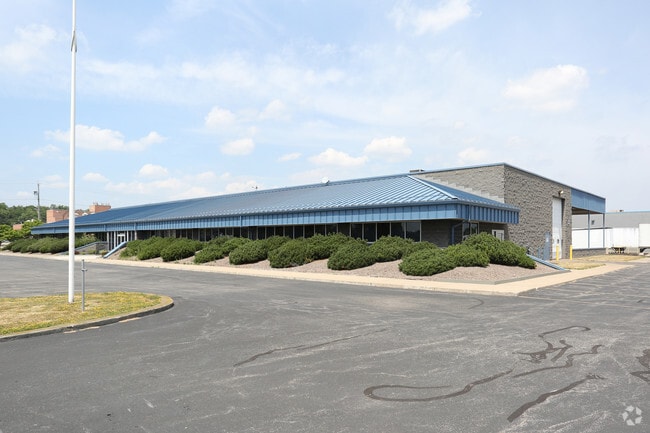
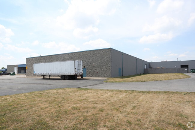
Property Record
155 Holleder Pkwy, Rochester, NY 14615


Property Detail
155 Holleder Pkwy
Rochester, NY
MONROE
261400 090.54-1-1.006
New York
Manufacturinglight
1.006
2025
4.72 AC
2025
Greater Rochester
001800
Rochester
78,444 SF
NEARBY LISTINGS FOR SALE OR LEASE
DEMOGRAPHICS near 155 Holleder Pkwy
1 mile
3 mile
5 mile
2025 Total Population
9,129
113,559
300,873
2030 Population
9,081
112,258
297,744
Pop Growth 2025-2030
(0.53%)
(1.15%)
(1.04%)
Average Age
36
39
40
2025 Total Households
3,610
47,620
129,457
HH Growth 2025-2030
(0.42%)
(1.11%)
(1.03%)
Median Household Inc
$52,956
$47,866
$55,127
Avg Household Size
2.40
2.30
2.20
2025 Avg HH Vehicles
1.00
1.00
1.00
Median Home Value
$116,314
$137,334
$157,294
Median Year Built
1947
1954
1954
Nearby Places
Map Layers
Map Styles
 Street
 Aerial
Layers
 Traffic
 Biking
Places
Listings with unknown addresses are not visible on the map
- Restaurants
- Banks
- Shops
- Fitness
- Groceries
PUBLIC TRANSPORTATION
AIRPORT
Frederick Douglass/Greater Rochester International
Drive
Walk
Distance
Frederick Douglass/Greater Rochester International
14 min
8.2 mi
Nearby Properties
Address
Land Use
TOTAL SIZE
Lot Size
Zoning
Address
Land Use
TOTAL SIZE
Lot Size
Zoning
181,500 SF
57.85 AC
Address
Land Use
TOTAL SIZE
Lot Size
Zoning
64,041 SF
42.66 AC
Address
Land Use
TOTAL SIZE
Lot Size
Zoning
57,550 SF
46.61 AC
05 - COMME
Address
Land Use
TOTAL SIZE
Lot Size
Zoning
Address
Land Use
TOTAL SIZE
Lot Size
Zoning
13.10 AC
Address
Land Use
TOTAL SIZE
Lot Size
Zoning
18,831 SF
70.63 AC
Address
Land Use
TOTAL SIZE
Lot Size
Zoning
7,200 SF
12.35 AC
Address
Land Use
TOTAL SIZE
Lot Size
Zoning
0.01 AC
Address
Land Use
TOTAL SIZE
Lot Size
Zoning
119,777 SF
14.38 AC
06 - INDUS
Address
Land Use
TOTAL SIZE
Lot Size
Zoning
491,375 SF
5.90 AC
Address
Land Use
TOTAL SIZE
Lot Size
Zoning
410,400 SF
2.88 AC
Address
Land Use
TOTAL SIZE
Lot Size
Zoning
225,793 SF
32.60 AC
Address
Land Use
TOTAL SIZE
Lot Size
Zoning
227,808 SF
69.10 AC
Address
Land Use
TOTAL SIZE
Lot Size
Zoning
1.06 AC
Address
Land Use
TOTAL SIZE
Lot Size
Zoning
83,632 SF
3.48 AC
02 - SINGL
Address
Land Use
TOTAL SIZE
Lot Size
Zoning
149,541 SF
6.10 AC
03 - MULTI
Address
Land Use
TOTAL SIZE
Lot Size
Zoning
2.63 AC
Address
Land Use
TOTAL SIZE
Lot Size
Zoning
273,663 SF
80.37 AC
Address
Land Use
TOTAL SIZE
Lot Size
Zoning
274,700 SF
24.79 AC
Address
Land Use
TOTAL SIZE
Lot Size
Zoning
6,617 SF
274.69 AC
Address
Land Use
TOTAL SIZE
Lot Size
Zoning
3,281 SF
17.99 AC
Address
Land Use
TOTAL SIZE
Lot Size
Zoning
3,710 SF
30.20 AC
05 - COMME
Address
Land Use
TOTAL SIZE
Lot Size
Zoning
391,478 SF
29.27 AC
Address
Land Use
TOTAL SIZE
Lot Size
Zoning
250,500 SF
18 AC
Address
Land Use
TOTAL SIZE
Lot Size
Zoning
119,983 SF
17.80 AC
03 - MULTI
Address
Land Use
TOTAL SIZE
Lot Size
Zoning
1,899,594 SF
87.90 AC
Address
Land Use
TOTAL SIZE
Lot Size
Zoning
205,616 SF
3.10 AC
Address
Land Use
TOTAL SIZE
Lot Size
Zoning
Address
Land Use
TOTAL SIZE
Lot Size
Zoning
2,855 SF
243.50 AC
Address
Land Use
TOTAL SIZE
Lot Size
Zoning
374,864 SF
25.87 AC
The World's #1 Commercial Real Estate Marketplace
Connect with us
© 2026 CoStar Group
The information above has been obtained from sources believed reliable. While we do not doubt its accuracy we have not verified it and make no guarantee, warranty or representation about it. It is your responsibility to independently confirm its accuracy and completeness. Any projections, opinions, assumptions, or estimates used are for example only and do not represent the current or future performance of the property. The value of this transaction to you depends on tax and other factors which should be evaluated by your tax, financial, and legal advisors. You and your advisors should conduct a careful, independent investigation of the property to determine to your satisfaction the suitability of the property for your needs.