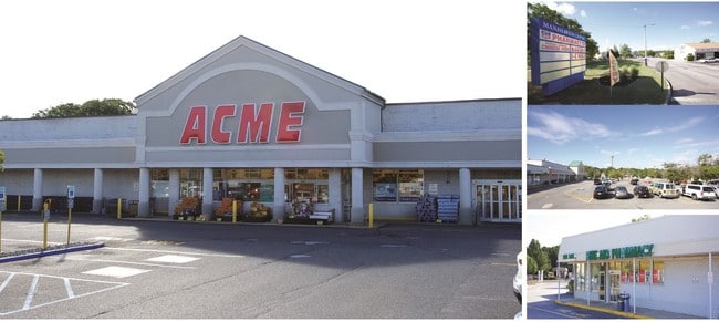
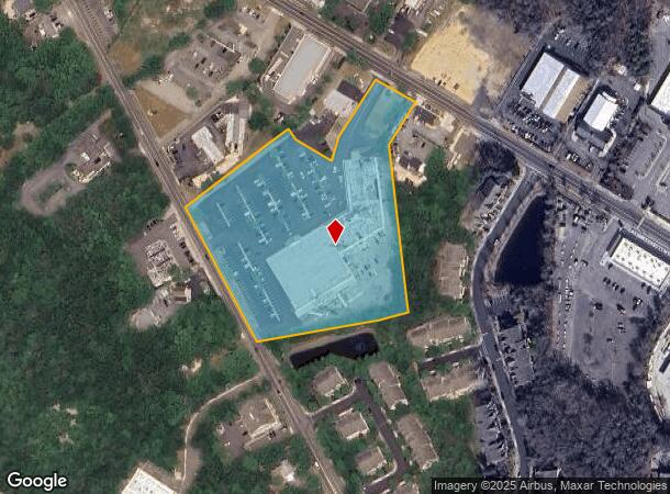
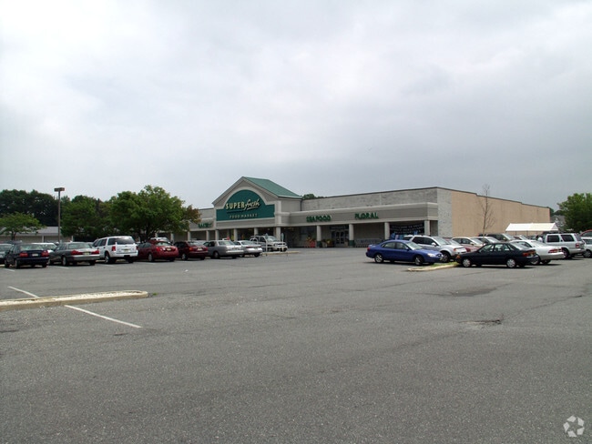
Property Record
609 E Bay Ave, Barnegat, NJ 08005

NEARBY LISTINGS FOR SALE OR LEASE
Property Detail
609 E Bay Ave
New York-Jersey City-White Plains, NY-NJ
6.03 AC.
31-00158-0000-00006-01
Ocean
Commercialnec
New Jersey
X
6.1
34029C0511G
6.03 AC
2024
Ocean County
2025
Northern New Jersey
734003
DEMOGRAPHICS near 609 E Bay Ave
1 Mile
3 Mile
5 Mile
2024 Total Population
4,077
16,396
51,999
2029 Population
4,590
18,390
57,592
Pop Growth 2024-2029
+ 12.58%
+ 12.16%
+ 10.76%
Average Age
47
47
44
2024 Total Households
1,775
7,024
20,433
HH Growth 2024-2029
+ 12.39%
+ 12.12%
+ 11.16%
Median Household Inc
$98,648
$98,173
$94,573
Avg Household Size
2.30
2.30
2.40
2024 Avg HH Vehicles
2.00
2.00
2.00
Median Home Value
$363,976
$425,866
$385,914
Median Year Built
1984
1988
1985
Nearby Places
Map Layers
Map Styles
 Street
 Aerial
- Restaurants
- Banks
- Shops
- Fitness
- Groceries
PUBLIC TRANSPORTATION
AIRPORT
Atlantic City International
DRIVE
WALK
Distance
Atlantic City International
63 min
33.3 mi
Freight Ports
South Jersey Port
DRIVE
WALK
Distance
South Jersey Port
72 min
55.0 mi
SALE & LEASE HISTORY
LISTING DATE
SALE/LEASE

Oct 24, 2016
For Sale
Nov 21, 2016
For Sale
Mar 24, 2017
For Lease
Nearby Properties
Address
Land Use
TOTAL SIZE
Lot Size
Zoning
Address
Land Use
TOTAL SIZE
Lot Size
Zoning
129 AC
PU
Address
Land Use
TOTAL SIZE
Lot Size
Zoning
107,490 SF
30 AC
HC
Address
Land Use
TOTAL SIZE
Lot Size
Zoning
15.71 AC
BP
Address
Land Use
TOTAL SIZE
Lot Size
Zoning
12.04 AC
BP
Address
Land Use
TOTAL SIZE
Lot Size
Zoning
15.03 AC
BP
Address
Land Use
TOTAL SIZE
Lot Size
Zoning
9,920 SF
20.75 AC
HC
Address
Land Use
TOTAL SIZE
Lot Size
Zoning
4,232 SF
119.80 AC
R3P/
Address
Land Use
TOTAL SIZE
Lot Size
Zoning
125,352 SF
12.86 AC
HC
Address
Land Use
TOTAL SIZE
Lot Size
Zoning
118,850 SF
21.73 AC
HC
Address
Land Use
TOTAL SIZE
Lot Size
Zoning
100,988 SF
7.72 AC
HC
Address
Land Use
TOTAL SIZE
Lot Size
Zoning
4,479 SF
18.27 AC
MU
Address
Land Use
TOTAL SIZE
Lot Size
Zoning
44.75 AC
MLS/
Address
Land Use
TOTAL SIZE
Lot Size
Zoning
55,605 SF
9.25 AC
HC
Address
Land Use
TOTAL SIZE
Lot Size
Zoning
91.97 AC
RGL/
Address
Land Use
TOTAL SIZE
Lot Size
Zoning
116,625 SF
17.46 AC
HC
Address
Land Use
TOTAL SIZE
Lot Size
Zoning
101,202 SF
16.10 AC
HC
Address
Land Use
TOTAL SIZE
Lot Size
Zoning
11.06 AC
MLS/
Address
Land Use
TOTAL SIZE
Lot Size
Zoning
9.86 AC
RA4/
Address
Land Use
TOTAL SIZE
Lot Size
Zoning
37.27 AC
RGL/
Address
Land Use
TOTAL SIZE
Lot Size
Zoning
6.36 AC
RGL/
Address
Land Use
TOTAL SIZE
Lot Size
Zoning
52,572 SF
6.74 AC
HC
Address
Land Use
TOTAL SIZE
Lot Size
Zoning
44,487 SF
10.42 AC
HC
Address
Land Use
TOTAL SIZE
Lot Size
Zoning
2,880 SF
6.34 AC
MUHC
Address
Land Use
TOTAL SIZE
Lot Size
Zoning
5.25 AC
Address
Land Use
TOTAL SIZE
Lot Size
Zoning
8.60 AC
PS/C
Address
Land Use
TOTAL SIZE
Lot Size
Zoning
15.03 AC
BP
Address
Land Use
TOTAL SIZE
Lot Size
Zoning
14,651 SF
9.31 AC
ML
Address
Land Use
TOTAL SIZE
Lot Size
Zoning
18.47 AC
PS/C
Address
Land Use
TOTAL SIZE
Lot Size
Zoning
15.71 AC
BP
Address
Land Use
TOTAL SIZE
Lot Size
Zoning
7.16 AC
MU
The World's #1 Commercial Real Estate Marketplace
Connect with us
© 2025 CoStar Group
The information above has been obtained from sources believed reliable. While we do not doubt its accuracy we have not verified it and make no guarantee, warranty or representation about it. It is your responsibility to independently confirm its accuracy and completeness. Any projections, opinions, assumptions, or estimates used are for example only and do not represent the current or future performance of the property. The value of this transaction to you depends on tax and other factors which should be evaluated by your tax, financial, and legal advisors. You and your advisors should conduct a careful, independent investigation of the property to determine to your satisfaction the suitability of the property for your needs.