Property Record
4225 Glass Rd Ne, Cedar Rapids, IA 52402
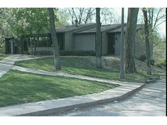

Property Detail
4225 Glass Rd Ne
Cedar Rapids, IA
SIGNAL RIDGE 1ST STR/LB 1
14071-80004-00000
Linn
Medicalbuilding
Iowa
B and X Area of moderate flood hazard, usually the area between the limits of the 100-year and 500-year floods.
1
2024
2.04 AC
2025
Iowa City/Waterloo
000902
Other Market Areas
5,604 SF
NEARBY LISTINGS FOR SALE OR LEASE
DEMOGRAPHICS near 4225 Glass Rd Ne
1 mile
3 mile
5 mile
2025 Total Population
4,942
48,487
136,665
2030 Population
4,996
48,746
138,242
Pop Growth 2025-2030
+ 1.09%
+ 0.53%
+ 1.15%
Average Age
45
41
40
2025 Total Households
2,162
20,512
57,574
HH Growth 2025-2030
+ 0.97%
+ 0.47%
+ 1.21%
Median Household Inc
$98,753
$68,667
$68,343
Avg Household Size
2.20
2.20
2.30
2025 Avg HH Vehicles
2.00
2.00
2.00
Median Home Value
$280,448
$202,284
$200,133
Median Year Built
1984
1974
1973
Nearby Places
Map Layers
Map Styles
 Street
 Aerial
Layers
 Traffic
 Biking
Places
Listings with unknown addresses are not visible on the map
- Restaurants
- Banks
- Shops
- Fitness
- Groceries
PUBLIC TRANSPORTATION
AIRPORT
The Eastern Iowa
Drive
Walk
Distance
The Eastern Iowa
18 min
9.7 mi
Freight Ports
Port Milwaukee
Drive
Walk
Distance
Port Milwaukee
293 min
246.7 mi
SALE & LEASE HISTORY
LISTING DATE
SALE/LEASE

May 11, 2023
For Lease
Aug 06, 2020
For Lease
Nearby Properties
Address
Land Use
TOTAL SIZE
Lot Size
Zoning
Address
Land Use
TOTAL SIZE
Lot Size
Zoning
276,234 SF
44.53 AC
Address
Land Use
TOTAL SIZE
Lot Size
Zoning
97,940 SF
52.22 AC
Address
Land Use
TOTAL SIZE
Lot Size
Zoning
103,528 SF
18.54 AC
Address
Land Use
TOTAL SIZE
Lot Size
Zoning
140,672 SF
15.99 AC
Address
Land Use
TOTAL SIZE
Lot Size
Zoning
189,595 SF
19.12 AC
Address
Land Use
TOTAL SIZE
Lot Size
Zoning
110,583 SF
15.56 AC
Address
Land Use
TOTAL SIZE
Lot Size
Zoning
34,710 SF
3.30 AC
Address
Land Use
TOTAL SIZE
Lot Size
Zoning
69,683 SF
24.78 AC
Address
Land Use
TOTAL SIZE
Lot Size
Zoning
61,291 SF
35.88 AC
Address
Land Use
TOTAL SIZE
Lot Size
Zoning
67,108 SF
4.81 AC
Address
Land Use
TOTAL SIZE
Lot Size
Zoning
225,076 SF
17.04 AC
Address
Land Use
TOTAL SIZE
Lot Size
Zoning
173,941 SF
15.45 AC
Address
Land Use
TOTAL SIZE
Lot Size
Zoning
63,234 SF
2.20 AC
Address
Land Use
TOTAL SIZE
Lot Size
Zoning
60,616 SF
8.40 AC
Address
Land Use
TOTAL SIZE
Lot Size
Zoning
61,505 SF
28.08 AC
Address
Land Use
TOTAL SIZE
Lot Size
Zoning
2,041,280 SF
99 AC
Address
Land Use
TOTAL SIZE
Lot Size
Zoning
36,328 SF
4.40 AC
Address
Land Use
TOTAL SIZE
Lot Size
Zoning
98,080 SF
8.09 AC
Address
Land Use
TOTAL SIZE
Lot Size
Zoning
23,800 SF
65.76 AC
Address
Land Use
TOTAL SIZE
Lot Size
Zoning
36,464 SF
9.02 AC
Address
Land Use
TOTAL SIZE
Lot Size
Zoning
83,312 SF
11.36 AC
Address
Land Use
TOTAL SIZE
Lot Size
Zoning
135,941 SF
15.67 AC
Address
Land Use
TOTAL SIZE
Lot Size
Zoning
22,794 SF
99 AC
Address
Land Use
TOTAL SIZE
Lot Size
Zoning
58,289 SF
4 AC
Address
Land Use
TOTAL SIZE
Lot Size
Zoning
204,266 SF
17.97 AC
Address
Land Use
TOTAL SIZE
Lot Size
Zoning
130,752 SF
26.02 AC
Address
Land Use
TOTAL SIZE
Lot Size
Zoning
76,762 SF
6.46 AC
Address
Land Use
TOTAL SIZE
Lot Size
Zoning
24,632 SF
3.36 AC
Address
Land Use
TOTAL SIZE
Lot Size
Zoning
54,096 SF
13.95 AC
Address
Land Use
TOTAL SIZE
Lot Size
Zoning
7,852 SF
30.03 AC
The World's #1 Commercial Real Estate Marketplace
Connect with us
© 2026 CoStar Group
The information above has been obtained from sources believed reliable. While we do not doubt its accuracy we have not verified it and make no guarantee, warranty or representation about it. It is your responsibility to independently confirm its accuracy and completeness. Any projections, opinions, assumptions, or estimates used are for example only and do not represent the current or future performance of the property. The value of this transaction to you depends on tax and other factors which should be evaluated by your tax, financial, and legal advisors. You and your advisors should conduct a careful, independent investigation of the property to determine to your satisfaction the suitability of the property for your needs.