Property Record
10 Riordan Rd, Bella Vista, AR 72714
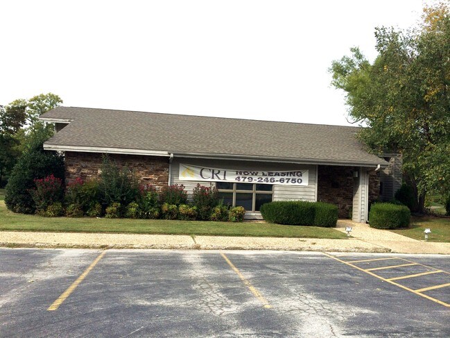

Property Detail
10 Riordan Rd
Fayetteville-Springdale-Rogers, AR
PLAT 11/15/91 22-140 & 3/27/98 23L-209 AG EDWARDS SITS HERE SURVEYS: 10/28/2020 L202069811
16-40213-000
Benton
Apartment
Arkansas
AE The base floodplain where base flood elevations are provided. AE Zones are now used on new format FIRMs instead of A1-A30 Zones.
5
2025
0.51 AC
2025
Outlying Benton County
020805
Fayetteville/Springdale/Rogers
13,839 SF
NEARBY LISTINGS FOR SALE OR LEASE
DEMOGRAPHICS near 10 Riordan Rd
1 mile
3 mile
5 mile
2025 Total Population
2,657
22,042
47,378
2030 Population
2,923
24,375
52,420
Pop Growth 2025-2030
+ 10.01%
+ 10.58%
+ 10.64%
Average Age
46
44
43
2025 Total Households
1,161
9,062
18,908
HH Growth 2025-2030
+ 10.25%
+ 10.83%
+ 10.89%
Median Household Inc
$108,473
$102,026
$103,234
Avg Household Size
2.30
2.40
2.50
2025 Avg HH Vehicles
2.00
2.00
2.00
Median Home Value
$343,678
$353,651
$377,341
Median Year Built
1994
1995
1997
Nearby Places
Map Layers
Map Styles
 Street
 Aerial
Layers
 Traffic
 Biking
Places
Listings with unknown addresses are not visible on the map
- Restaurants
- Banks
- Shops
- Fitness
- Groceries
PUBLIC TRANSPORTATION
AIRPORT
Northwest Arkansas Ntl
Drive
Walk
Distance
Northwest Arkansas Ntl
30 min
17.1 mi
SALE & LEASE HISTORY
LISTING DATE
SALE/LEASE

Sep 24, 2016
For Sale
May 15, 2020
For Sale
Nearby Properties
Address
Land Use
TOTAL SIZE
Lot Size
Zoning
Address
Land Use
TOTAL SIZE
Lot Size
Zoning
31,870 SF
9.52 AC
Address
Land Use
TOTAL SIZE
Lot Size
Zoning
138,513 SF
15.06 AC
Address
Land Use
TOTAL SIZE
Lot Size
Zoning
27,440 SF
4.54 AC
Address
Land Use
TOTAL SIZE
Lot Size
Zoning
53,834 SF
7.82 AC
Address
Land Use
TOTAL SIZE
Lot Size
Zoning
86,153 SF
5 AC
Address
Land Use
TOTAL SIZE
Lot Size
Zoning
14,258 SF
1.64 AC
Address
Land Use
TOTAL SIZE
Lot Size
Zoning
48,552 SF
9.49 AC
Address
Land Use
TOTAL SIZE
Lot Size
Zoning
10,545 SF
1.97 AC
Address
Land Use
TOTAL SIZE
Lot Size
Zoning
106,920 SF
6.85 AC
Address
Land Use
TOTAL SIZE
Lot Size
Zoning
14,743 SF
2.68 AC
Address
Land Use
TOTAL SIZE
Lot Size
Zoning
29,560 SF
4.51 AC
Address
Land Use
TOTAL SIZE
Lot Size
Zoning
9,268 SF
3.80 AC
Address
Land Use
TOTAL SIZE
Lot Size
Zoning
28,089 SF
13.79 AC
Address
Land Use
TOTAL SIZE
Lot Size
Zoning
27,314 SF
5.97 AC
Address
Land Use
TOTAL SIZE
Lot Size
Zoning
10,964 SF
4.41 AC
Address
Land Use
TOTAL SIZE
Lot Size
Zoning
3,180 SF
0.08 AC
Address
Land Use
TOTAL SIZE
Lot Size
Zoning
38,633 SF
3.17 AC
Address
Land Use
TOTAL SIZE
Lot Size
Zoning
65,143 SF
6.31 AC
Address
Land Use
TOTAL SIZE
Lot Size
Zoning
6,669 SF
7.98 AC
Address
Land Use
TOTAL SIZE
Lot Size
Zoning
9,940 SF
1.75 AC
Address
Land Use
TOTAL SIZE
Lot Size
Zoning
13,080 SF
1.15 AC
Address
Land Use
TOTAL SIZE
Lot Size
Zoning
3,648 SF
2.97 AC
Address
Land Use
TOTAL SIZE
Lot Size
Zoning
45,064 SF
2.91 AC
Address
Land Use
TOTAL SIZE
Lot Size
Zoning
11,380 SF
0.28 AC
Address
Land Use
TOTAL SIZE
Lot Size
Zoning
14,008 SF
2 AC
Address
Land Use
TOTAL SIZE
Lot Size
Zoning
19,976 SF
0.58 AC
Address
Land Use
TOTAL SIZE
Lot Size
Zoning
15,450 SF
1.95 AC
Address
Land Use
TOTAL SIZE
Lot Size
Zoning
29,453 SF
6.26 AC
Address
Land Use
TOTAL SIZE
Lot Size
Zoning
2.02 AC
The World's #1 Commercial Real Estate Marketplace
Connect with us
© 2026 CoStar Group
The information above has been obtained from sources believed reliable. While we do not doubt its accuracy we have not verified it and make no guarantee, warranty or representation about it. It is your responsibility to independently confirm its accuracy and completeness. Any projections, opinions, assumptions, or estimates used are for example only and do not represent the current or future performance of the property. The value of this transaction to you depends on tax and other factors which should be evaluated by your tax, financial, and legal advisors. You and your advisors should conduct a careful, independent investigation of the property to determine to your satisfaction the suitability of the property for your needs.