Property Record
1611 Fulenwider Rd, Gainesville, GA 30507
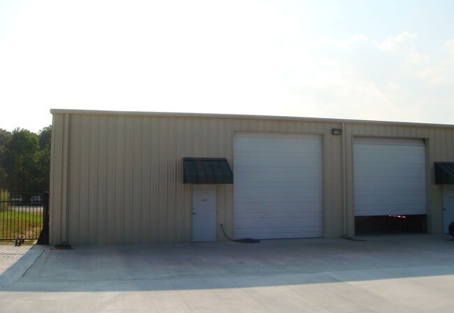

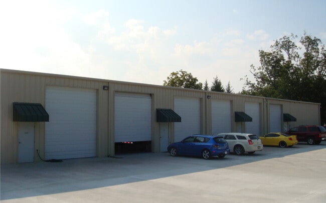
Property Detail
1611 Fulenwider Rd
15-00031-00-120
1611 FULENWIDER ROAD
Industrialgeneral
Hall
I-1
Georgia
B and X Area of moderate flood hazard, usually the area between the limits of the 100-year and 500-year floods.
0
2025
2.20 AC
2025
I-985/Gainesville
001204
Atlanta
11,620 SF
Gainesville, GA
NEARBY LISTINGS FOR SALE OR LEASE
DEMOGRAPHICS near 1611 Fulenwider Rd
1 mile
3 mile
5 mile
2025 Total Population
282
23,195
78,554
2030 Population
305
25,053
85,016
Pop Growth 2025-2030
+ 8.16%
+ 8.01%
+ 8.23%
Average Age
36
34
36
2025 Total Households
49
6,253
25,044
HH Growth 2025-2030
+ 10.20%
+ 8.08%
+ 8.30%
Median Household Inc
$84,722
$67,177
$64,201
Avg Household Size
3.80
3.40
3.00
2025 Avg HH Vehicles
3.00
2.00
2.00
Median Home Value
$192,856
$236,129
$280,781
Median Year Built
1995
1994
1993
Nearby Places
Map Layers
Map Styles
 Street
 Aerial
Layers
 Traffic
 Biking
Places
Listings with unknown addresses are not visible on the map
- Restaurants
- Banks
- Shops
- Fitness
- Groceries
SALE & LEASE HISTORY
LISTING DATE
SALE/LEASE

Oct 02, 2024
For Lease
Nearby Properties
Address
Land Use
TOTAL SIZE
Lot Size
Zoning
Address
Land Use
TOTAL SIZE
Lot Size
Zoning
578,645 SF
110.18 AC
PUD
Address
Land Use
TOTAL SIZE
Lot Size
Zoning
334,800 SF
56.96 AC
PUD
Address
Land Use
TOTAL SIZE
Lot Size
Zoning
273,931 SF
34.09 AC
I-1
Address
Land Use
TOTAL SIZE
Lot Size
Zoning
258,201 SF
38.83 AC
I-1
Address
Land Use
TOTAL SIZE
Lot Size
Zoning
3,284 SF
28.53 AC
PUD
Address
Land Use
TOTAL SIZE
Lot Size
Zoning
346,875 SF
82.09 AC
H-I
Address
Land Use
TOTAL SIZE
Lot Size
Zoning
54,751 SF
33.38 AC
AR-1
Address
Land Use
TOTAL SIZE
Lot Size
Zoning
469,180 SF
25.56 AC
H-I
Address
Land Use
TOTAL SIZE
Lot Size
Zoning
258,372 SF
24.38 AC
L-I
Address
Land Use
TOTAL SIZE
Lot Size
Zoning
88,042 SF
280.24 AC
PID
Address
Land Use
TOTAL SIZE
Lot Size
Zoning
1,191 SF
262.63 AC
H-I
Address
Land Use
TOTAL SIZE
Lot Size
Zoning
258,800 SF
52.20 AC
H-I
Address
Land Use
TOTAL SIZE
Lot Size
Zoning
304,088 SF
17.45 AC
H-I
Address
Land Use
TOTAL SIZE
Lot Size
Zoning
102,996 SF
10.94 AC
L-I
Address
Land Use
TOTAL SIZE
Lot Size
Zoning
199,610 SF
14.66 AC
L-I
Address
Land Use
TOTAL SIZE
Lot Size
Zoning
194,850 SF
9.28 AC
L-I
Address
Land Use
TOTAL SIZE
Lot Size
Zoning
91,728 SF
15 AC
L-I
Address
Land Use
TOTAL SIZE
Lot Size
Zoning
286,880 SF
18.38 AC
H-I
Address
Land Use
TOTAL SIZE
Lot Size
Zoning
18,126 SF
14.65 AC
AR-1
Address
Land Use
TOTAL SIZE
Lot Size
Zoning
206,125 SF
32.78 AC
L-I
Address
Land Use
TOTAL SIZE
Lot Size
Zoning
145,064 SF
7.47 AC
I-1
Address
Land Use
TOTAL SIZE
Lot Size
Zoning
6,720 SF
1,027.20 AC
EX
Address
Land Use
TOTAL SIZE
Lot Size
Zoning
162,813 SF
11.24 AC
H-I
Address
Land Use
TOTAL SIZE
Lot Size
Zoning
50,000 SF
12.53 AC
L-I
Address
Land Use
TOTAL SIZE
Lot Size
Zoning
20,250 SF
23.43 AC
H-I
Address
Land Use
TOTAL SIZE
Lot Size
Zoning
43,170 SF
23.06 AC
PUD
Address
Land Use
TOTAL SIZE
Lot Size
Zoning
67,624 SF
163.46 AC
EX
Address
Land Use
TOTAL SIZE
Lot Size
Zoning
108,239 SF
16.54 AC
H-I
Address
Land Use
TOTAL SIZE
Lot Size
Zoning
90,000 SF
10.66 AC
H-I
Address
Land Use
TOTAL SIZE
Lot Size
Zoning
207,402 SF
15.30 AC
H-I
The World's #1 Commercial Real Estate Marketplace
Connect with us
© 2026 CoStar Group
The information above has been obtained from sources believed reliable. While we do not doubt its accuracy we have not verified it and make no guarantee, warranty or representation about it. It is your responsibility to independently confirm its accuracy and completeness. Any projections, opinions, assumptions, or estimates used are for example only and do not represent the current or future performance of the property. The value of this transaction to you depends on tax and other factors which should be evaluated by your tax, financial, and legal advisors. You and your advisors should conduct a careful, independent investigation of the property to determine to your satisfaction the suitability of the property for your needs.