Property Record
930 Old Monrovia Rd Nw, Huntsville, AL 35806


Property Detail
930 Old Monrovia Rd Nw
Huntsville, AL
.46 AC LYING IN THE SW 1/4 OF NW 1/4 OF SEC 32 W OF HOLMES AVE UTILITY STATION SEC 32 T3 R1W
14-09-31-0-000-010.000
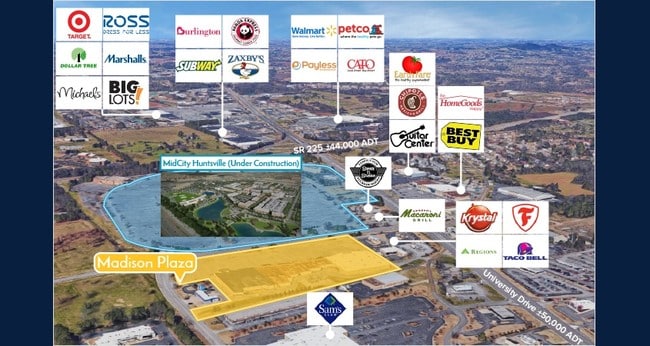
MADISON
Commercialnec
Alabama
B and X Area of moderate flood hazard, usually the area between the limits of the 100-year and 500-year floods.
4.87 AC
0
Cummings Research Park
2025
Huntsville
001404
NEARBY LISTINGS FOR SALE OR LEASE
DEMOGRAPHICS near 930 Old Monrovia Rd Nw
1 mile
3 mile
5 mile
2025 Total Population
5,622
50,014
127,908
2030 Population
6,069
53,792
137,656
Pop Growth 2025-2030
+ 7.95%
+ 7.55%
+ 7.62%
Average Age
33
36
38
2025 Total Households
2,786
22,249
55,084
HH Growth 2025-2030
+ 7.86%
+ 7.82%
+ 7.88%
Median Household Inc
$47,180
$55,835
$59,591
Avg Household Size
1.70
2.00
2.20
2025 Avg HH Vehicles
1.00
2.00
2.00
Median Home Value
$178,831
$196,147
$260,581
Median Year Built
1985
1984
1983
Nearby Places
Map Layers
Map Styles
 Street
 Aerial
Layers
 Traffic
 Biking
Places
Listings with unknown addresses are not visible on the map
- Restaurants
- Banks
- Shops
- Fitness
- Groceries
PUBLIC TRANSPORTATION
AIRPORT
Huntsville International-Carl T Jones Field
Drive
Walk
Distance
Huntsville International-Carl T Jones Field
18 min
12.1 mi
Freight Ports
Port of Mobile
Drive
Walk
Distance
Port of Mobile
386 min
353.3 mi
SALE & LEASE HISTORY
LISTING DATE
SALE/LEASE

Sep 25, 2016
For Lease
Nearby Properties
Address
Land Use
TOTAL SIZE
Lot Size
Zoning
Address
Land Use
TOTAL SIZE
Lot Size
Zoning
61,684 SF
52 AC
Address
Land Use
TOTAL SIZE
Lot Size
Zoning
34,373 SF
20.08 AC
Address
Land Use
TOTAL SIZE
Lot Size
Zoning
89,358 SF
Address
Land Use
TOTAL SIZE
Lot Size
Zoning
5,577 SF
12.72 AC
Address
Land Use
TOTAL SIZE
Lot Size
Zoning
59,317 SF
3.38 AC
Address
Land Use
TOTAL SIZE
Lot Size
Zoning
4,470 SF
20 AC
Address
Land Use
TOTAL SIZE
Lot Size
Zoning
4,681 SF
8.36 AC
Address
Land Use
TOTAL SIZE
Lot Size
Zoning
31,050 SF
Address
Land Use
TOTAL SIZE
Lot Size
Zoning
56,426 SF
13.78 AC
Address
Land Use
TOTAL SIZE
Lot Size
Zoning
195,300 SF
Address
Land Use
TOTAL SIZE
Lot Size
Zoning
25,619 SF
Address
Land Use
TOTAL SIZE
Lot Size
Zoning
10,399 SF
31.50 AC
Address
Land Use
TOTAL SIZE
Lot Size
Zoning
343,176 SF
23 AC
Address
Land Use
TOTAL SIZE
Lot Size
Zoning
6,258 SF
14 AC
Address
Land Use
TOTAL SIZE
Lot Size
Zoning
1,454 SF
14.22 AC
Address
Land Use
TOTAL SIZE
Lot Size
Zoning
3,644 SF
25.74 AC
Address
Land Use
TOTAL SIZE
Lot Size
Zoning
28,890 SF
3.15 AC
Address
Land Use
TOTAL SIZE
Lot Size
Zoning
76,644 SF
14 AC
Address
Land Use
TOTAL SIZE
Lot Size
Zoning
8,258 SF
15.30 AC
Address
Land Use
TOTAL SIZE
Lot Size
Zoning
45,420 SF
11 AC
Address
Land Use
TOTAL SIZE
Lot Size
Zoning
76,079 SF
12.71 AC
Address
Land Use
TOTAL SIZE
Lot Size
Zoning
3,922 SF
15 AC
Address
Land Use
TOTAL SIZE
Lot Size
Zoning
41,624 SF
3.80 AC
Address
Land Use
TOTAL SIZE
Lot Size
Zoning
2,517 SF
35 AC
Address
Land Use
TOTAL SIZE
Lot Size
Zoning
57,286 SF
7.30 AC
Address
Land Use
TOTAL SIZE
Lot Size
Zoning
59,390 SF
20 AC
Address
Land Use
TOTAL SIZE
Lot Size
Zoning
Address
Land Use
TOTAL SIZE
Lot Size
Zoning
25,619 SF
Address
Land Use
TOTAL SIZE
Lot Size
Zoning
156,778 SF
18.45 AC
Address
Land Use
TOTAL SIZE
Lot Size
Zoning
24,840 SF
1.02 AC
The World's #1 Commercial Real Estate Marketplace
Connect with us
© 2026 CoStar Group
The information above has been obtained from sources believed reliable. While we do not doubt its accuracy we have not verified it and make no guarantee, warranty or representation about it. It is your responsibility to independently confirm its accuracy and completeness. Any projections, opinions, assumptions, or estimates used are for example only and do not represent the current or future performance of the property. The value of this transaction to you depends on tax and other factors which should be evaluated by your tax, financial, and legal advisors. You and your advisors should conduct a careful, independent investigation of the property to determine to your satisfaction the suitability of the property for your needs.