Property Record
590 Danbury Rd, Ridgefield, CT 06877
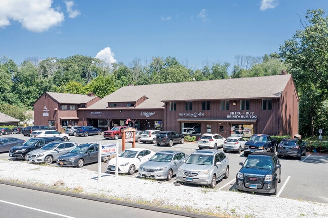

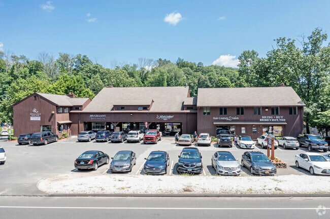
Property Detail
590 Danbury Rd
RIDG-000009-G000599
Western Ct
Commercialacreage
Connecticut
NBZ
1.52 AC
C and X Area of minimal flood hazard, usually depicted on FIRMs as above the 500-year flood level.
Ridgefield
2025
Westchester/So Connecticut
2025
Bridgeport-Stamford-Danbury, CT
245200
NEARBY LISTINGS FOR SALE OR LEASE
DEMOGRAPHICS near 590 Danbury Rd
1 mile
3 mile
5 mile
2025 Total Population
2,526
19,129
62,081
2030 Population
2,652
19,697
63,528
Pop Growth 2025-2030
+ 4.99%
+ 2.97%
+ 2.33%
Average Age
46
44
42
2025 Total Households
866
7,067
22,980
HH Growth 2025-2030
+ 5.31%
+ 3.00%
+ 2.36%
Median Household Inc
$166,706
$150,478
$117,391
Avg Household Size
2.70
2.60
2.60
2025 Avg HH Vehicles
2.00
2.00
2.00
Median Home Value
$722,334
$735,494
$650,663
Median Year Built
1984
1971
1971
Nearby Places
Map Layers
Map Styles
 Street
 Aerial
Layers
 Traffic
 Biking
Places
Listings with unknown addresses are not visible on the map
- Restaurants
- Banks
- Shops
- Fitness
- Groceries
PUBLIC TRANSPORTATION
COMMUTER RAIL
Redding Station (New Haven Line - Metro-North Commuter Railroad Company (Metro-North))
Drive
Walk
Distance
Redding Station (New Haven Line - Metro-North Commuter Railroad Company (Metro-North))
10 min
4.3 mi
Branchville Station (New Haven Line - Metro-North Commuter Railroad Company (Metro-North))
Drive
Walk
Distance
Branchville Station (New Haven Line - Metro-North Commuter Railroad Company (Metro-North))
6 min
4.5 mi
AIRPORT
Westchester County
Drive
Walk
Distance
Westchester County
43 min
29.7 mi
Tweed/New Haven
Drive
Walk
Distance
Tweed/New Haven
68 min
45.6 mi
New York Stewart International
Drive
Walk
Distance
New York Stewart International
65 min
47.9 mi
Freight Ports
Port of New Haven
Drive
Walk
Distance
Port of New Haven
63 min
42.8 mi
SALE & LEASE HISTORY
LISTING DATE
SALE/LEASE

Jun 12, 2017
For Lease
Jan 14, 2019
For Lease
Feb 19, 2021
For Lease
Feb 03, 2021
For Sale
Apr 04, 2024
For Lease
Nearby Properties
Address
Land Use
TOTAL SIZE
Lot Size
Zoning
Address
Land Use
TOTAL SIZE
Lot Size
Zoning
3,676 SF
77.59 AC
RAA
Address
Land Use
TOTAL SIZE
Lot Size
Zoning
162,265 SF
15.22 AC
B-1
Address
Land Use
TOTAL SIZE
Lot Size
Zoning
5,902 SF
30.40 AC
B-2
Address
Land Use
TOTAL SIZE
Lot Size
Zoning
108,918 SF
3.91 AC
B-2
Address
Land Use
TOTAL SIZE
Lot Size
Zoning
92,775 SF
85.83 AC
RAA
Address
Land Use
TOTAL SIZE
Lot Size
Zoning
117,561 SF
16.23 AC
RCDD
Address
Land Use
TOTAL SIZE
Lot Size
Zoning
100,734 SF
22.55 AC
B-2
Address
Land Use
TOTAL SIZE
Lot Size
Zoning
16,389 SF
7.42 AC
CAH
Address
Land Use
TOTAL SIZE
Lot Size
Zoning
4,226 SF
11.13 AC
B-2
Address
Land Use
TOTAL SIZE
Lot Size
Zoning
52,703 SF
48.18 AC
CCF
Address
Land Use
TOTAL SIZE
Lot Size
Zoning
14,215 SF
32.35 AC
RAA
Address
Land Use
TOTAL SIZE
Lot Size
Zoning
49,239 SF
13.01 AC
RA
Address
Land Use
TOTAL SIZE
Lot Size
Zoning
49,638 SF
12.24 AC
RAA
Address
Land Use
TOTAL SIZE
Lot Size
Zoning
12,348 SF
16 AC
RA
Address
Land Use
TOTAL SIZE
Lot Size
Zoning
1,238 SF
8.03 AC
ARHD2
Address
Land Use
TOTAL SIZE
Lot Size
Zoning
2,694 SF
156.19 AC
CDD
Address
Land Use
TOTAL SIZE
Lot Size
Zoning
16,822 SF
4.98 AC
RA
Address
Land Use
TOTAL SIZE
Lot Size
Zoning
8,291 SF
1.23 AC
CBD
Address
Land Use
TOTAL SIZE
Lot Size
Zoning
48,811 SF
20.21 AC
RAA
Address
Land Use
TOTAL SIZE
Lot Size
Zoning
23,852 SF
4.67 AC
CBD
Address
Land Use
TOTAL SIZE
Lot Size
Zoning
273.40 AC
RAAA
Address
Land Use
TOTAL SIZE
Lot Size
Zoning
32,036 SF
1.95 AC
CBD
Address
Land Use
TOTAL SIZE
Lot Size
Zoning
7,138 SF
13.27 AC
RAA
Address
Land Use
TOTAL SIZE
Lot Size
Zoning
240.15 AC
IP
Address
Land Use
TOTAL SIZE
Lot Size
Zoning
266.80 AC
RAA
Address
Land Use
TOTAL SIZE
Lot Size
Zoning
16,968 SF
0.90 AC
CBD
Address
Land Use
TOTAL SIZE
Lot Size
Zoning
18,530 SF
2 AC
B-1
Address
Land Use
TOTAL SIZE
Lot Size
Zoning
3,865 SF
5.11 AC
MFDD
Address
Land Use
TOTAL SIZE
Lot Size
Zoning
35,745 SF
2.20 AC
B-2
Address
Land Use
TOTAL SIZE
Lot Size
Zoning
17,088 SF
2.81 AC
B-2
The World's #1 Commercial Real Estate Marketplace
Connect with us
© 2026 CoStar Group
The information above has been obtained from sources believed reliable. While we do not doubt its accuracy we have not verified it and make no guarantee, warranty or representation about it. It is your responsibility to independently confirm its accuracy and completeness. Any projections, opinions, assumptions, or estimates used are for example only and do not represent the current or future performance of the property. The value of this transaction to you depends on tax and other factors which should be evaluated by your tax, financial, and legal advisors. You and your advisors should conduct a careful, independent investigation of the property to determine to your satisfaction the suitability of the property for your needs.