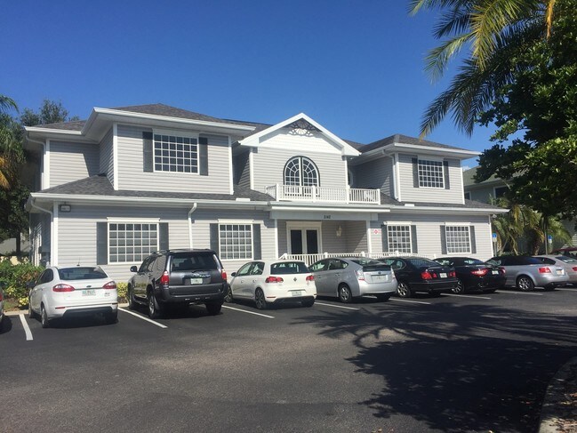
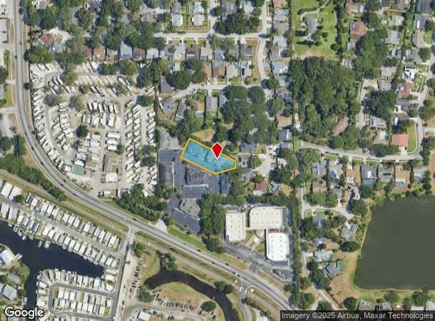
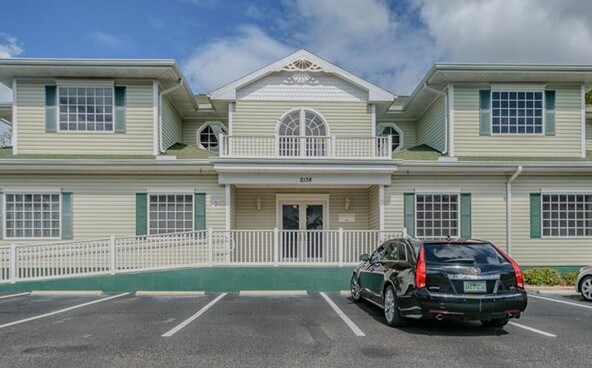
Property Record
2142 Alt 19, Palm Harbor, FL 34683

NEARBY LISTINGS FOR SALE OR LEASE
Property Detail
2142 Alt 19
35-27-15-16885-001-0014
Coconut Grove Office Condo
Officecondo
COCONUT GROVE OFFICE CONDO BLDG 1, UNIT 1-D
X
Pinellas
12103C0059H
Florida
2024
0.54 AC
2025
North Pinellas
027206
Tampa/St Petersburg
1,420 SF
Tampa-St. Petersburg-Clearwater, FL
DEMOGRAPHICS near 2142 Alt 19
1 Mile
3 Mile
5 Mile
2024 Total Population
5,980
53,372
131,715
2029 Population
5,761
52,909
131,282
Pop Growth 2024-2029
(3.66%)
(0.87%)
(0.33%)
Average Age
45
49
49
2024 Total Households
2,345
24,037
60,261
HH Growth 2024-2029
(4.31%)
(0.89%)
(0.44%)
Median Household Inc
$87,857
$67,481
$66,262
Avg Household Size
2.40
2.10
2.10
2024 Avg HH Vehicles
2.00
2.00
2.00
Median Home Value
$409,024
$340,916
$326,693
Median Year Built
1982
1983
1983
Nearby Places
- Restaurants
- Banks
- Shops
- Fitness
- Groceries
PUBLIC TRANSPORTATION
AIRPORT
Tampa International
DRIVE
WALK
Distance
Tampa International
37 min
20.3 mi
St Pete-Clearwater International
DRIVE
WALK
Distance
St Pete-Clearwater International
37 min
20.4 mi
SALE & LEASE HISTORY
LISTING DATE
SALE/LEASE

Mar 06, 2024
For Lease
Mar 06, 2024
For Sale
Jun 27, 2018
For Sale
Feb 07, 2017
For Lease
Nearby Properties
Address
Land Use
TOTAL SIZE
Lot Size
Zoning
Address
Land Use
TOTAL SIZE
Lot Size
Zoning
535,063 SF
34.58 AC
RPD5
Address
Land Use
TOTAL SIZE
Lot Size
Zoning
270,606 SF
53.27 AC
AE
Address
Land Use
TOTAL SIZE
Lot Size
Zoning
242,708 SF
26.17 AC
RPD10
Address
Land Use
TOTAL SIZE
Lot Size
Zoning
171,009 SF
49.16 AC
RPD10
Address
Land Use
TOTAL SIZE
Lot Size
Zoning
208,427 SF
12.11 AC
Address
Land Use
TOTAL SIZE
Lot Size
Zoning
188,845 SF
33.69 AC
RPD5
Address
Land Use
TOTAL SIZE
Lot Size
Zoning
144,838 SF
15.52 AC
CP1
Address
Land Use
TOTAL SIZE
Lot Size
Zoning
199,825 SF
22.75 AC
R2
Address
Land Use
TOTAL SIZE
Lot Size
Zoning
151,398 SF
15.55 AC
CP1
Address
Land Use
TOTAL SIZE
Lot Size
Zoning
311,414 SF
15.59 AC
RPD75
Address
Land Use
TOTAL SIZE
Lot Size
Zoning
116,975 SF
9 AC
AE
Address
Land Use
TOTAL SIZE
Lot Size
Zoning
137,649 SF
8.08 AC
Address
Land Use
TOTAL SIZE
Lot Size
Zoning
173,160 SF
5.39 AC
Address
Land Use
TOTAL SIZE
Lot Size
Zoning
273,134 SF
1.44 AC
RPD5
Address
Land Use
TOTAL SIZE
Lot Size
Zoning
446,974 SF
11.32 AC
AE
Address
Land Use
TOTAL SIZE
Lot Size
Zoning
99,361 SF
12.64 AC
CP1
Address
Land Use
TOTAL SIZE
Lot Size
Zoning
92,817 SF
6.42 AC
PC
Address
Land Use
TOTAL SIZE
Lot Size
Zoning
112,719 SF
9.36 AC
CP1
Address
Land Use
TOTAL SIZE
Lot Size
Zoning
36,668 SF
65.18 AC
AE
Address
Land Use
TOTAL SIZE
Lot Size
Zoning
93,413 SF
12.35 AC
RPD10
Address
Land Use
TOTAL SIZE
Lot Size
Zoning
93,840 SF
8.66 AC
CP1
Address
Land Use
TOTAL SIZE
Lot Size
Zoning
117,262 SF
15.32 AC
CP1
Address
Land Use
TOTAL SIZE
Lot Size
Zoning
65,929 SF
5.96 AC
C2
Address
Land Use
TOTAL SIZE
Lot Size
Zoning
97,776 SF
9.63 AC
Address
Land Use
TOTAL SIZE
Lot Size
Zoning
103,393 SF
17.68 AC
R4
Address
Land Use
TOTAL SIZE
Lot Size
Zoning
101,243 SF
5.36 AC
M1
Address
Land Use
TOTAL SIZE
Lot Size
Zoning
84,170 SF
9.95 AC
Address
Land Use
TOTAL SIZE
Lot Size
Zoning
63,088 SF
7.50 AC
RPD10
Address
Land Use
TOTAL SIZE
Lot Size
Zoning
79,665 SF
7.26 AC
CP1
Address
Land Use
TOTAL SIZE
Lot Size
Zoning
60,187 SF
7.39 AC
CP1
The World's #1 Commercial Real Estate Marketplace
Connect with us
© 2025 CoStar Group
The information above has been obtained from sources believed reliable. While we do not doubt its accuracy we have not verified it and make no guarantee, warranty or representation about it. It is your responsibility to independently confirm its accuracy and completeness. Any projections, opinions, assumptions, or estimates used are for example only and do not represent the current or future performance of the property. The value of this transaction to you depends on tax and other factors which should be evaluated by your tax, financial, and legal advisors. You and your advisors should conduct a careful, independent investigation of the property to determine to your satisfaction the suitability of the property for your needs.