Property Record
2000 W Oak Dr, Lebanon, OR 97355
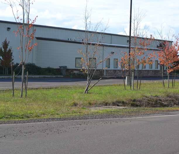

Property Detail
2000 W Oak Dr
0918046
12S02W1600
Municipalproperty
Linn
IND
Oregon
B and X Area of moderate flood hazard, usually the area between the limits of the 100-year and 500-year floods.
11.03 AC
0
Linn County
2025
Portland
030905
Albany, OR
NEARBY LISTINGS FOR SALE OR LEASE
DEMOGRAPHICS near 2000 W Oak Dr
1 mile
3 mile
5 mile
2025 Total Population
3,067
23,676
28,062
2030 Population
3,163
24,406
28,834
Pop Growth 2025-2030
+ 3.13%
+ 3.08%
+ 2.75%
Average Age
39
40
40
2025 Total Households
1,176
9,192
10,792
HH Growth 2025-2030
+ 3.15%
+ 3.15%
+ 2.84%
Median Household Inc
$63,814
$61,424
$63,230
Avg Household Size
2.60
2.50
2.50
2025 Avg HH Vehicles
2.00
2.00
2.00
Median Home Value
$293,306
$356,888
$376,316
Median Year Built
1974
1977
1977
Nearby Places
Map Layers
Map Styles
 Street
 Aerial
Layers
 Traffic
 Biking
Places
Listings with unknown addresses are not visible on the map
- Restaurants
- Banks
- Shops
- Fitness
- Groceries
PUBLIC TRANSPORTATION
AIRPORT
Mahlon Sweet Field
Drive
Walk
Distance
Mahlon Sweet Field
65 min
44.7 mi
Nearby Properties
Address
Land Use
TOTAL SIZE
Lot Size
Zoning
Address
Land Use
TOTAL SIZE
Lot Size
Zoning
152.97 AC
IND
Address
Land Use
TOTAL SIZE
Lot Size
Zoning
23,713 SF
25.64 AC
PUB
Address
Land Use
TOTAL SIZE
Lot Size
Zoning
6.76 AC
PUB
Address
Land Use
TOTAL SIZE
Lot Size
Zoning
5.51 AC
IND
Address
Land Use
TOTAL SIZE
Lot Size
Zoning
18.88 AC
MU
Address
Land Use
TOTAL SIZE
Lot Size
Zoning
2.84 AC
MU
Address
Land Use
TOTAL SIZE
Lot Size
Zoning
7.66 AC
MU
Address
Land Use
TOTAL SIZE
Lot Size
Zoning
39,440 SF
13.71 AC
MU
Address
Land Use
TOTAL SIZE
Lot Size
Zoning
3 AC
MU
Address
Land Use
TOTAL SIZE
Lot Size
Zoning
85,756 SF
35.19 AC
PUB
Address
Land Use
TOTAL SIZE
Lot Size
Zoning
12.89 AC
IND
Address
Land Use
TOTAL SIZE
Lot Size
Zoning
4.97 AC
MU
Address
Land Use
TOTAL SIZE
Lot Size
Zoning
52,058 SF
10 AC
PUB
Address
Land Use
TOTAL SIZE
Lot Size
Zoning
5.12 AC
RH
Address
Land Use
TOTAL SIZE
Lot Size
Zoning
1.34 AC
CH
Address
Land Use
TOTAL SIZE
Lot Size
Zoning
73,935 SF
3.82 AC
RM
Address
Land Use
TOTAL SIZE
Lot Size
Zoning
1,436 SF
3.84 AC
RM
Address
Land Use
TOTAL SIZE
Lot Size
Zoning
9,731 SF
4.27 AC
PUB
Address
Land Use
TOTAL SIZE
Lot Size
Zoning
17,528 SF
7.39 AC
PUB
Address
Land Use
TOTAL SIZE
Lot Size
Zoning
1,440 SF
4.91 AC
IND
Address
Land Use
TOTAL SIZE
Lot Size
Zoning
50,519 SF
11.48 AC
RM
Address
Land Use
TOTAL SIZE
Lot Size
Zoning
4.76 AC
RM
Address
Land Use
TOTAL SIZE
Lot Size
Zoning
11,862 SF
10.13 AC
PUB
Address
Land Use
TOTAL SIZE
Lot Size
Zoning
2.59 AC
MU
Address
Land Use
TOTAL SIZE
Lot Size
Zoning
1,328 SF
5 AC
UGA-EFU-80
Address
Land Use
TOTAL SIZE
Lot Size
Zoning
6.30 AC
IND
Address
Land Use
TOTAL SIZE
Lot Size
Zoning
92,580 SF
7.52 AC
UGA-EFU-80
Address
Land Use
TOTAL SIZE
Lot Size
Zoning
3.90 AC
PUB
Address
Land Use
TOTAL SIZE
Lot Size
Zoning
25,414 SF
18.76 AC
EFU
Address
Land Use
TOTAL SIZE
Lot Size
Zoning
6.83 AC
IND
The World's #1 Commercial Real Estate Marketplace
Connect with us
© 2026 CoStar Group
The information above has been obtained from sources believed reliable. While we do not doubt its accuracy we have not verified it and make no guarantee, warranty or representation about it. It is your responsibility to independently confirm its accuracy and completeness. Any projections, opinions, assumptions, or estimates used are for example only and do not represent the current or future performance of the property. The value of this transaction to you depends on tax and other factors which should be evaluated by your tax, financial, and legal advisors. You and your advisors should conduct a careful, independent investigation of the property to determine to your satisfaction the suitability of the property for your needs.