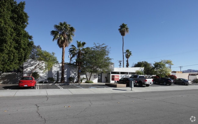
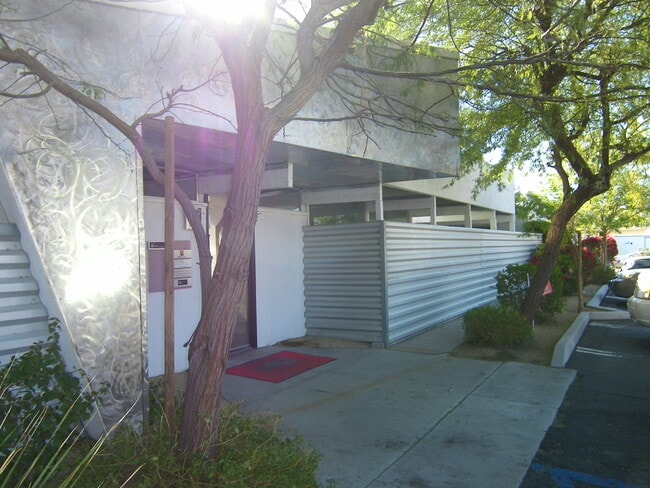
Property Record
550 S Oleander Rd, Palm Springs, CA 92264


Property Detail
550 S Oleander Rd
680-092-008
POR LOT 2 MB 014/652 SD PALM VALLEY COLONY LANDS AND POR PAR 2 RS 013/027
Medicalbuilding
Riverside
M1
California
B and X Area of moderate flood hazard, usually the area between the limits of the 100-year and 500-year floods.
2
2024
0.48 AC
2025
Coachella Valley
044804
Inland Empire (California)
4,517 SF
Riverside-San Bernardino-Ontario, CA
NEARBY LISTINGS FOR SALE OR LEASE
DEMOGRAPHICS near 550 S Oleander Rd
1 mile
3 mile
5 mile
2025 Total Population
5,907
92,275
135,672
2030 Population
6,277
98,250
145,561
Pop Growth 2025-2030
+ 6.26%
+ 6.48%
+ 7.29%
Average Age
43
47
49
2025 Total Households
2,197
40,476
62,294
HH Growth 2025-2030
+ 6.33%
+ 7.18%
+ 7.77%
Median Household Inc
$66,808
$71,956
$76,634
Avg Household Size
2.60
2.20
2.10
2025 Avg HH Vehicles
2.00
2.00
2.00
Median Home Value
$610,019
$620,508
$669,470
Median Year Built
1974
1983
1984
Nearby Places
Map Layers
Map Styles
 Street
 Aerial
Layers
 Traffic
 Biking
Places
Listings with unknown addresses are not visible on the map
- Restaurants
- Banks
- Shops
- Fitness
- Groceries
PUBLIC TRANSPORTATION
COMMUTER RAIL
Drive
Walk
Distance
16 min
8.5 mi
AIRPORT
Palm Springs International
Drive
Walk
Distance
Palm Springs International
5 min
1.9 mi
SALE & LEASE HISTORY
LISTING DATE
SALE/LEASE

Aug 20, 2021
For Lease
Nearby Properties
Address
Land Use
TOTAL SIZE
Lot Size
Zoning
Address
Land Use
TOTAL SIZE
Lot Size
Zoning
97,065 SF
4.64 AC
R3
Address
Land Use
TOTAL SIZE
Lot Size
Zoning
197,439 SF
8.76 AC
Address
Land Use
TOTAL SIZE
Lot Size
Zoning
91,939 SF
8.80 AC
Address
Land Use
TOTAL SIZE
Lot Size
Zoning
332,356 SF
9.05 AC
Address
Land Use
TOTAL SIZE
Lot Size
Zoning
35,188 SF
5.98 AC
R3
Address
Land Use
TOTAL SIZE
Lot Size
Zoning
148,746 SF
6.21 AC
R3
Address
Land Use
TOTAL SIZE
Lot Size
Zoning
225,833 SF
22 AC
Address
Land Use
TOTAL SIZE
Lot Size
Zoning
207,931 SF
6.34 AC
C1AA
Address
Land Use
TOTAL SIZE
Lot Size
Zoning
129,852 SF
11.17 AC
Address
Land Use
TOTAL SIZE
Lot Size
Zoning
5,509 SF
10.06 AC
PCC
Address
Land Use
TOTAL SIZE
Lot Size
Zoning
120,754 SF
14.30 AC
Address
Land Use
TOTAL SIZE
Lot Size
Zoning
322,000 SF
19.09 AC
Address
Land Use
TOTAL SIZE
Lot Size
Zoning
3.20 AC
GR5
Address
Land Use
TOTAL SIZE
Lot Size
Zoning
48,958 SF
0.96 AC
Address
Land Use
TOTAL SIZE
Lot Size
Zoning
70,670 SF
3.90 AC
R4
Address
Land Use
TOTAL SIZE
Lot Size
Zoning
31,488 SF
3.40 AC
A
Address
Land Use
TOTAL SIZE
Lot Size
Zoning
133,920 SF
8.26 AC
R1
Address
Land Use
TOTAL SIZE
Lot Size
Zoning
114,044 SF
5.40 AC
R3
Address
Land Use
TOTAL SIZE
Lot Size
Zoning
109,231 SF
5.57 AC
R4
Address
Land Use
TOTAL SIZE
Lot Size
Zoning
Address
Land Use
TOTAL SIZE
Lot Size
Zoning
53,229 SF
8.80 AC
Address
Land Use
TOTAL SIZE
Lot Size
Zoning
41,962 SF
5 AC
Address
Land Use
TOTAL SIZE
Lot Size
Zoning
86,810 SF
3.60 AC
R4VP
Address
Land Use
TOTAL SIZE
Lot Size
Zoning
38,388 SF
8.31 AC
R3
Address
Land Use
TOTAL SIZE
Lot Size
Zoning
103,526 SF
11.40 AC
Address
Land Use
TOTAL SIZE
Lot Size
Zoning
51,852 SF
4.04 AC
Address
Land Use
TOTAL SIZE
Lot Size
Zoning
238,554 SF
13.31 AC
R1
Address
Land Use
TOTAL SIZE
Lot Size
Zoning
81,687 SF
4.97 AC
R3
Address
Land Use
TOTAL SIZE
Lot Size
Zoning
176,519 SF
12.60 AC
The World's #1 Commercial Real Estate Marketplace
Connect with us
© 2026 CoStar Group
The information above has been obtained from sources believed reliable. While we do not doubt its accuracy we have not verified it and make no guarantee, warranty or representation about it. It is your responsibility to independently confirm its accuracy and completeness. Any projections, opinions, assumptions, or estimates used are for example only and do not represent the current or future performance of the property. The value of this transaction to you depends on tax and other factors which should be evaluated by your tax, financial, and legal advisors. You and your advisors should conduct a careful, independent investigation of the property to determine to your satisfaction the suitability of the property for your needs.