Property Record
3690 N Peachtree Rd, Atlanta, GA 30341
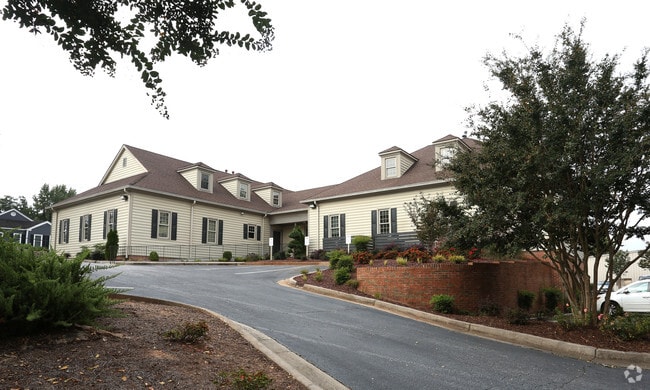

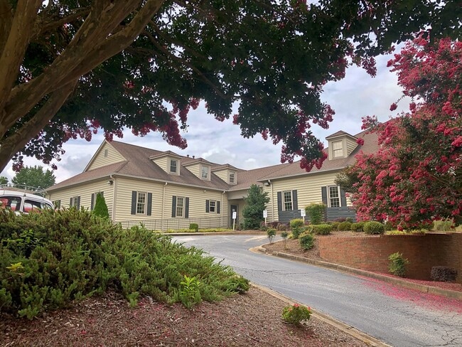

Property Detail
3690 N Peachtree Rd
18-309-02-101
PARCEL 3
Officebuilding
DeKalb
X
Georgia
B and X Area of moderate flood hazard, usually the area between the limits of the 100-year and 500-year floods.
b
2025
1.03 AC
2025
Chamblee/Dville/N D Hills
021208
Atlanta
17,264 SF
Atlanta-Sandy Springs-Roswell, GA
NEARBY LISTINGS FOR SALE OR LEASE
DEMOGRAPHICS near 3690 N Peachtree Rd
1 mile
3 mile
5 mile
2025 Total Population
10,122
103,605
294,901
2030 Population
10,465
105,501
300,037
Pop Growth 2025-2030
+ 3.39%
+ 1.83%
+ 1.74%
Average Age
35
37
38
2025 Total Households
3,789
42,043
122,948
HH Growth 2025-2030
+ 4.06%
+ 1.83%
+ 1.69%
Median Household Inc
$68,866
$83,483
$94,247
Avg Household Size
2.60
2.40
2.30
2025 Avg HH Vehicles
1.00
2.00
2.00
Median Home Value
$435,426
$497,404
$564,193
Median Year Built
1974
1982
1986
Nearby Places
Map Layers
Map Styles
 Street
 Aerial
Layers
 Traffic
 Biking
Places
Listings with unknown addresses are not visible on the map
- Restaurants
- Banks
- Shops
- Fitness
- Groceries
PUBLIC TRANSPORTATION
AIRPORT
Hartsfield - Jackson Atlanta International
Drive
Walk
Distance
Hartsfield - Jackson Atlanta International
37 min
23.3 mi
Freight Ports
Georgia Ports - Savannah
Drive
Walk
Distance
Georgia Ports - Savannah
293 min
261.5 mi
SALE & LEASE HISTORY
LISTING DATE
SALE/LEASE

Aug 13, 2021
For Sale
Nearby Properties
Address
Land Use
TOTAL SIZE
Lot Size
Zoning
Address
Land Use
TOTAL SIZE
Lot Size
Zoning
705,518 SF
39.09 AC
M
Address
Land Use
TOTAL SIZE
Lot Size
Zoning
12,600 SF
508.30 AC
M
Address
Land Use
TOTAL SIZE
Lot Size
Zoning
376,010 SF
3.76 AC
OI
Address
Land Use
TOTAL SIZE
Lot Size
Zoning
299,993 SF
4.72 AC
I1
Address
Land Use
TOTAL SIZE
Lot Size
Zoning
519,706 SF
6.70 AC
X
Address
Land Use
TOTAL SIZE
Lot Size
Zoning
213,408 SF
6.35 AC
I1
Address
Land Use
TOTAL SIZE
Lot Size
Zoning
296,627 SF
9.21 AC
X
Address
Land Use
TOTAL SIZE
Lot Size
Zoning
542,845 SF
10.58 AC
X
Address
Land Use
TOTAL SIZE
Lot Size
Zoning
432,424 SF
3.87 AC
MC
Address
Land Use
TOTAL SIZE
Lot Size
Zoning
276,504 SF
3.40 AC
C1
Address
Land Use
TOTAL SIZE
Lot Size
Zoning
140,183 SF
4.20 AC
OI
Address
Land Use
TOTAL SIZE
Lot Size
Zoning
103,056 SF
8.66 AC
OI
Address
Land Use
TOTAL SIZE
Lot Size
Zoning
157,133 SF
5.03 AC
M
Address
Land Use
TOTAL SIZE
Lot Size
Zoning
166,377 SF
7.56 AC
X
Address
Land Use
TOTAL SIZE
Lot Size
Zoning
283,784 SF
30.88 AC
RM100
Address
Land Use
TOTAL SIZE
Lot Size
Zoning
204,376 SF
14.23 AC
X
Address
Land Use
TOTAL SIZE
Lot Size
Zoning
106,770 SF
3.13 AC
X
Address
Land Use
TOTAL SIZE
Lot Size
Zoning
366,276 SF
11.54 AC
RM-HD
Address
Land Use
TOTAL SIZE
Lot Size
Zoning
345,441 SF
25.78 AC
C1
Address
Land Use
TOTAL SIZE
Lot Size
Zoning
267,983 SF
13 AC
X
Address
Land Use
TOTAL SIZE
Lot Size
Zoning
253,055 SF
2.65 AC
X
Address
Land Use
TOTAL SIZE
Lot Size
Zoning
214,915 SF
3.55 AC
Address
Land Use
TOTAL SIZE
Lot Size
Zoning
406,188 SF
4.43 AC
X
Address
Land Use
TOTAL SIZE
Lot Size
Zoning
325,232 SF
23.10 AC
X
Address
Land Use
TOTAL SIZE
Lot Size
Zoning
262,900 SF
4.70 AC
OI
Address
Land Use
TOTAL SIZE
Lot Size
Zoning
108,006 SF
11.23 AC
X
Address
Land Use
TOTAL SIZE
Lot Size
Zoning
204,012 SF
6.89 AC
X
Address
Land Use
TOTAL SIZE
Lot Size
Zoning
169,476 SF
3 AC
MC
Address
Land Use
TOTAL SIZE
Lot Size
Zoning
536,151 SF
30.35 AC
X
Address
Land Use
TOTAL SIZE
Lot Size
Zoning
234,474 SF
7 AC
X
The World's #1 Commercial Real Estate Marketplace
Connect with us
© 2026 CoStar Group
The information above has been obtained from sources believed reliable. While we do not doubt its accuracy we have not verified it and make no guarantee, warranty or representation about it. It is your responsibility to independently confirm its accuracy and completeness. Any projections, opinions, assumptions, or estimates used are for example only and do not represent the current or future performance of the property. The value of this transaction to you depends on tax and other factors which should be evaluated by your tax, financial, and legal advisors. You and your advisors should conduct a careful, independent investigation of the property to determine to your satisfaction the suitability of the property for your needs.