Property Record
2135 Sw 19Th Avenue Rd, Ocala, FL 34471


Property Detail
2135 Sw 19Th Avenue Rd
23721-005-03
SEC 24 TWP 15 RGE 21 COM AT THE NE COR OF THE SE 1/4 OF SW 1/4 TH N 89-21-10 W PERPENDICULAR TO THE E BDY OF SAID SE 1/4 OF SW 1/4 80 FT TO THE POB TH S 00-39-13 W PARALLEL TO SAID E BDY 259.32 FT TH N 89-20-47 W 217.89 FT TH N 31-47-44 W 351.94 FT T
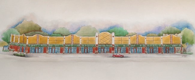
Regionalshoppingcenterormallwithanchorstore
Marion
B5
Florida
B and X Area of moderate flood hazard, usually the area between the limits of the 100-year and 500-year floods.
c-1
2025
2.32 AC
2025
Greater Ocala
002401
Ocala
17,000 SF
Ocala, FL
NEARBY LISTINGS FOR SALE OR LEASE
-
-
-
-
-
-
-
-
-
No Photo
-
View all Ocala listings for lease on LoopNet.com
DEMOGRAPHICS near 2135 Sw 19Th Avenue Rd
1 mile
3 mile
5 mile
2025 Total Population
4,815
39,702
87,849
2030 Population
5,362
44,541
98,581
Pop Growth 2025-2030
+ 11.36%
+ 12.19%
+ 12.22%
Average Age
38
40
41
2025 Total Households
2,047
15,818
35,955
HH Growth 2025-2030
+ 11.72%
+ 12.68%
+ 12.61%
Median Household Inc
$31,713
$52,514
$55,703
Avg Household Size
2.30
2.30
2.30
2025 Avg HH Vehicles
1.00
1.00
2.00
Median Home Value
$305,000
$288,200
$281,793
Median Year Built
1987
1984
1985
Nearby Places
Map Layers
Map Styles
 Street
 Aerial
Layers
 Traffic
 Biking
Places
Listings with unknown addresses are not visible on the map
- Restaurants
- Banks
- Shops
- Fitness
- Groceries
SALE & LEASE HISTORY
LISTING DATE
SALE/LEASE

Jul 06, 2017
For Lease
Nearby Properties
Address
Land Use
TOTAL SIZE
Lot Size
Zoning
Address
Land Use
TOTAL SIZE
Lot Size
Zoning
207,950 SF
14.08 AC
INST
Address
Land Use
TOTAL SIZE
Lot Size
Zoning
2,015,469 SF
169.30 AC
M1
Address
Land Use
TOTAL SIZE
Lot Size
Zoning
704,765 SF
71.04 AC
GU
Address
Land Use
TOTAL SIZE
Lot Size
Zoning
493,261 SF
126.01 AC
R3
Address
Land Use
TOTAL SIZE
Lot Size
Zoning
331,687 SF
11.66 AC
INST
Address
Land Use
TOTAL SIZE
Lot Size
Zoning
156,201 SF
36.77 AC
INST
Address
Land Use
TOTAL SIZE
Lot Size
Zoning
446,764 SF
138.06 AC
GU
Address
Land Use
TOTAL SIZE
Lot Size
Zoning
283,913 SF
24.22 AC
B2
Address
Land Use
TOTAL SIZE
Lot Size
Zoning
189,025 SF
35.42 AC
PD08
Address
Land Use
TOTAL SIZE
Lot Size
Zoning
164,363 SF
16.51 AC
R3
Address
Land Use
TOTAL SIZE
Lot Size
Zoning
195,992 SF
5.72 AC
FBC
Address
Land Use
TOTAL SIZE
Lot Size
Zoning
324,262 SF
40.79 AC
SC
Address
Land Use
TOTAL SIZE
Lot Size
Zoning
422,264 SF
40.87 AC
SC
Address
Land Use
TOTAL SIZE
Lot Size
Zoning
135,945 SF
22.30 AC
PD
Address
Land Use
TOTAL SIZE
Lot Size
Zoning
154,675 SF
23.62 AC
PD09
Address
Land Use
TOTAL SIZE
Lot Size
Zoning
87,034 SF
14.45 AC
R3
Address
Land Use
TOTAL SIZE
Lot Size
Zoning
178,015 SF
18.28 AC
PD07
Address
Land Use
TOTAL SIZE
Lot Size
Zoning
154,870 SF
23.50 AC
PD
Address
Land Use
TOTAL SIZE
Lot Size
Zoning
111,644 SF
19 AC
PD09
Address
Land Use
TOTAL SIZE
Lot Size
Zoning
222,210 SF
22.14 AC
SC
Address
Land Use
TOTAL SIZE
Lot Size
Zoning
92,049 SF
15.75 AC
R3
Address
Land Use
TOTAL SIZE
Lot Size
Zoning
65,570 SF
18.96 AC
PD
Address
Land Use
TOTAL SIZE
Lot Size
Zoning
110,226 SF
19.56 AC
PD09
Address
Land Use
TOTAL SIZE
Lot Size
Zoning
422,369 SF
51.11 AC
M2
Address
Land Use
TOTAL SIZE
Lot Size
Zoning
60,816 SF
13.67 AC
PD
Address
Land Use
TOTAL SIZE
Lot Size
Zoning
266,503 SF
25.48 AC
SC
Address
Land Use
TOTAL SIZE
Lot Size
Zoning
604,920 SF
42.92 AC
M1
Address
Land Use
TOTAL SIZE
Lot Size
Zoning
89,719 SF
15.16 AC
PD12
Address
Land Use
TOTAL SIZE
Lot Size
Zoning
194,275 SF
13.43 AC
M1
Address
Land Use
TOTAL SIZE
Lot Size
Zoning
186,474 SF
18.52 AC
SC
The World's #1 Commercial Real Estate Marketplace
Connect with us
© 2026 CoStar Group
The information above has been obtained from sources believed reliable. While we do not doubt its accuracy we have not verified it and make no guarantee, warranty or representation about it. It is your responsibility to independently confirm its accuracy and completeness. Any projections, opinions, assumptions, or estimates used are for example only and do not represent the current or future performance of the property. The value of this transaction to you depends on tax and other factors which should be evaluated by your tax, financial, and legal advisors. You and your advisors should conduct a careful, independent investigation of the property to determine to your satisfaction the suitability of the property for your needs.