Property Record
80 Technacenter Dr, Montgomery, AL 36117
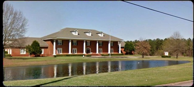


Property Detail
80 Technacenter Dr
09-06-14-1-000-003.000
0906141000003000
Officebuilding
Montgomery
O-2
Alabama
B and X Area of moderate flood hazard, usually the area between the limits of the 100-year and 500-year floods.
a
2025
4.90 AC
2025
Outlying Montgomery Cnty
005413
Montgomery
31,193 SF
Montgomery, AL
NEARBY LISTINGS FOR SALE OR LEASE
DEMOGRAPHICS near 80 Technacenter Dr
1 mile
3 mile
5 mile
2025 Total Population
1,902
22,562
58,378
2030 Population
1,874
22,005
56,844
Pop Growth 2025-2030
(1.47%)
(2.47%)
(2.63%)
Average Age
43
42
39
2025 Total Households
756
8,756
23,490
HH Growth 2025-2030
(1.59%)
(2.80%)
(2.85%)
Median Household Inc
$93,162
$93,598
$85,447
Avg Household Size
2.40
2.30
2.40
2025 Avg HH Vehicles
2.00
2.00
2.00
Median Home Value
$272,767
$292,079
$270,715
Median Year Built
1993
1998
1995
Nearby Places
Map Layers
Map Styles
 Street
 Aerial
Layers
 Traffic
 Biking
Places
Listings with unknown addresses are not visible on the map
- Restaurants
- Banks
- Shops
- Fitness
- Groceries
PUBLIC TRANSPORTATION
AIRPORT
Montgomery Regional (Dannelly Field)
Drive
Walk
Distance
Montgomery Regional (Dannelly Field)
26 min
19.6 mi
SALE & LEASE HISTORY
LISTING DATE
SALE/LEASE

Sep 25, 2016
For Lease
Nov 29, 2022
For Lease
Nearby Properties
Address
Land Use
TOTAL SIZE
Lot Size
Zoning
Address
Land Use
TOTAL SIZE
Lot Size
Zoning
117,161 SF
12.07 AC
INST
Address
Land Use
TOTAL SIZE
Lot Size
Zoning
5,118 SF
22.75 AC
R-65-M
Address
Land Use
TOTAL SIZE
Lot Size
Zoning
208,799 SF
17.34 AC
O-2
Address
Land Use
TOTAL SIZE
Lot Size
Zoning
160,604 SF
35.85 AC
B-2
Address
Land Use
TOTAL SIZE
Lot Size
Zoning
4,142 SF
25.96 AC
PUD
Address
Land Use
TOTAL SIZE
Lot Size
Zoning
4,597 SF
12.36 AC
PUD
Address
Land Use
TOTAL SIZE
Lot Size
Zoning
129,776 SF
6.13 AC
PUD
Address
Land Use
TOTAL SIZE
Lot Size
Zoning
1,996 SF
15.81 AC
PUD
Address
Land Use
TOTAL SIZE
Lot Size
Zoning
76,996 SF
15.51 AC
B-3
Address
Land Use
TOTAL SIZE
Lot Size
Zoning
38,646 SF
12.26 AC
PUD
Address
Land Use
TOTAL SIZE
Lot Size
Zoning
6,605 SF
6 AC
PUD
Address
Land Use
TOTAL SIZE
Lot Size
Zoning
344,095 SF
30.02 AC
Address
Land Use
TOTAL SIZE
Lot Size
Zoning
170,644 SF
12.34 AC
Address
Land Use
TOTAL SIZE
Lot Size
Zoning
57,408 SF
24.61 AC
Address
Land Use
TOTAL SIZE
Lot Size
Zoning
180,684 SF
21.94 AC
PUD
Address
Land Use
TOTAL SIZE
Lot Size
Zoning
127,082 SF
7.81 AC
PUD
Address
Land Use
TOTAL SIZE
Lot Size
Zoning
92,200 SF
9.74 AC
O-1
Address
Land Use
TOTAL SIZE
Lot Size
Zoning
217,723 SF
23.90 AC
B-2
Address
Land Use
TOTAL SIZE
Lot Size
Zoning
201,515 SF
4.46 AC
Address
Land Use
TOTAL SIZE
Lot Size
Zoning
30.36 AC
PUD
Address
Land Use
TOTAL SIZE
Lot Size
Zoning
125,121 SF
12.28 AC
PUD
Address
Land Use
TOTAL SIZE
Lot Size
Zoning
152,523 SF
13.96 AC
PUD
Address
Land Use
TOTAL SIZE
Lot Size
Zoning
82,638 SF
O-1
Address
Land Use
TOTAL SIZE
Lot Size
Zoning
31,521 SF
6.98 AC
PUD
Address
Land Use
TOTAL SIZE
Lot Size
Zoning
56,956 SF
10.37 AC
B-2
Address
Land Use
TOTAL SIZE
Lot Size
Zoning
52,600 SF
11.63 AC
Address
Land Use
TOTAL SIZE
Lot Size
Zoning
62,852 SF
2.46 AC
PUD
Address
Land Use
TOTAL SIZE
Lot Size
Zoning
89,675 SF
10.58 AC
PUD
Address
Land Use
TOTAL SIZE
Lot Size
Zoning
71,844 SF
2.73 AC
PUD
Address
Land Use
TOTAL SIZE
Lot Size
Zoning
9,792 SF
160 AC
The World's #1 Commercial Real Estate Marketplace
Connect with us
© 2026 CoStar Group
The information above has been obtained from sources believed reliable. While we do not doubt its accuracy we have not verified it and make no guarantee, warranty or representation about it. It is your responsibility to independently confirm its accuracy and completeness. Any projections, opinions, assumptions, or estimates used are for example only and do not represent the current or future performance of the property. The value of this transaction to you depends on tax and other factors which should be evaluated by your tax, financial, and legal advisors. You and your advisors should conduct a careful, independent investigation of the property to determine to your satisfaction the suitability of the property for your needs.