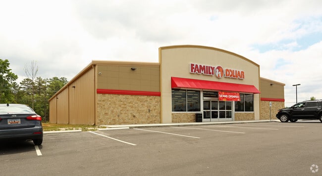
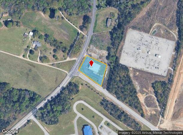
Property Record
8374 Wilson Blvd, Columbia, SC 29203
NEARBY LISTINGS FOR SALE OR LEASE
Property Detail
8374 Wilson Blvd
14505-03-01
LOT 181.6X245.3X241.5X301.7 #SU #PR RB1956-1483
Commercialnec
Richland
X
South Carolina
45079C0251L
181
2025
1.29 AC
2024
Northeast Columbia
011421
Columbia
8,400 SF
Columbia, SC
DEMOGRAPHICS near 8374 Wilson Blvd
1 Mile
3 Mile
5 Mile
2024 Total Population
1,687
26,364
93,845
2029 Population
1,693
26,808
95,515
Pop Growth 2024-2029
+ 0.36%
+ 1.68%
+ 1.78%
Average Age
42
40
39
2024 Total Households
694
11,108
38,709
HH Growth 2024-2029
+ 0.14%
+ 1.76%
+ 1.83%
Median Household Inc
$45,500
$44,092
$50,472
Avg Household Size
2.10
2.30
2.30
2024 Avg HH Vehicles
2.00
2.00
2.00
Median Home Value
$153,205
$148,529
$167,955
Median Year Built
1996
1984
1983
Nearby Places
Map Layers
Map Styles
 Street
 Aerial
- Restaurants
- Banks
- Shops
- Fitness
- Groceries
PUBLIC TRANSPORTATION
COMMUTER RAIL
Columbia Amtrak Station (Silver Star - Amtrak)
DRIVE
WALK
Distance
Columbia Amtrak Station (Silver Star - Amtrak)
18 min
9.6 mi
AIRPORT
Columbia Metro
DRIVE
WALK
Distance
Columbia Metro
34 min
20.0 mi
Freight Ports
North Charleston Terminal
DRIVE
WALK
Distance
North Charleston Terminal
134 min
116.2 mi
Nearby Properties
Address
Land Use
TOTAL SIZE
Lot Size
Zoning
Address
Land Use
TOTAL SIZE
Lot Size
Zoning
144,849 SF
26.14 AC
OI
Address
Land Use
TOTAL SIZE
Lot Size
Zoning
456,536 SF
42.16 AC
M-1
Address
Land Use
TOTAL SIZE
Lot Size
Zoning
83,808 SF
95.58 AC
PDD
Address
Land Use
TOTAL SIZE
Lot Size
Zoning
354,813 SF
20.66 AC
RM-HD
Address
Land Use
TOTAL SIZE
Lot Size
Zoning
325,344 SF
71.41 AC
HI
Address
Land Use
TOTAL SIZE
Lot Size
Zoning
172,390 SF
19.87 AC
GC
Address
Land Use
TOTAL SIZE
Lot Size
Zoning
234,990 SF
16.50 AC
RM-HD
Address
Land Use
TOTAL SIZE
Lot Size
Zoning
278,001 SF
28.82 AC
GC
Address
Land Use
TOTAL SIZE
Lot Size
Zoning
260,572 SF
15 AC
GC
Address
Land Use
TOTAL SIZE
Lot Size
Zoning
239,450 SF
16.85 AC
GC
Address
Land Use
TOTAL SIZE
Lot Size
Zoning
183,237 SF
13.65 AC
GC
Address
Land Use
TOTAL SIZE
Lot Size
Zoning
147,062 SF
13.20 AC
GC
Address
Land Use
TOTAL SIZE
Lot Size
Zoning
51,803 SF
11.99 AC
M-1
Address
Land Use
TOTAL SIZE
Lot Size
Zoning
217,580 SF
32.47 AC
M-1
Address
Land Use
TOTAL SIZE
Lot Size
Zoning
242,894 SF
14.97 AC
RM-HD
Address
Land Use
TOTAL SIZE
Lot Size
Zoning
138,552 SF
12.02 AC
RM-HD
Address
Land Use
TOTAL SIZE
Lot Size
Zoning
223,692 SF
12 AC
GC
Address
Land Use
TOTAL SIZE
Lot Size
Zoning
46,032 SF
11.11 AC
RM-HD
Address
Land Use
TOTAL SIZE
Lot Size
Zoning
111,327 SF
7.96 AC
RM-HD
Address
Land Use
TOTAL SIZE
Lot Size
Zoning
71,394 SF
12.05 AC
M-1
Address
Land Use
TOTAL SIZE
Lot Size
Zoning
72,938 SF
3.22 AC
M-1
Address
Land Use
TOTAL SIZE
Lot Size
Zoning
132,097 SF
10.63 AC
GC
Address
Land Use
TOTAL SIZE
Lot Size
Zoning
133,348 SF
18 AC
M-1
Address
Land Use
TOTAL SIZE
Lot Size
Zoning
80,000 SF
4.77 AC
M-1
Address
Land Use
TOTAL SIZE
Lot Size
Zoning
1,199.74 AC
OI
Address
Land Use
TOTAL SIZE
Lot Size
Zoning
84,909 SF
8.26 AC
GC
Address
Land Use
TOTAL SIZE
Lot Size
Zoning
88,710 SF
3.13 AC
GC
Address
Land Use
TOTAL SIZE
Lot Size
Zoning
55,747 SF
5.80 AC
M-1
Address
Land Use
TOTAL SIZE
Lot Size
Zoning
183,184 SF
10.63 AC
GC
Address
Land Use
TOTAL SIZE
Lot Size
Zoning
123,647 SF
16.05 AC
GC
The World's #1 Commercial Real Estate Marketplace
Connect with us
© 2025 CoStar Group
The information above has been obtained from sources believed reliable. While we do not doubt its accuracy we have not verified it and make no guarantee, warranty or representation about it. It is your responsibility to independently confirm its accuracy and completeness. Any projections, opinions, assumptions, or estimates used are for example only and do not represent the current or future performance of the property. The value of this transaction to you depends on tax and other factors which should be evaluated by your tax, financial, and legal advisors. You and your advisors should conduct a careful, independent investigation of the property to determine to your satisfaction the suitability of the property for your needs.