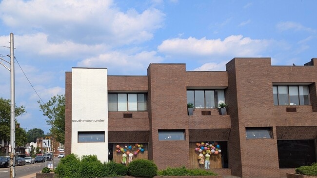
Property Record
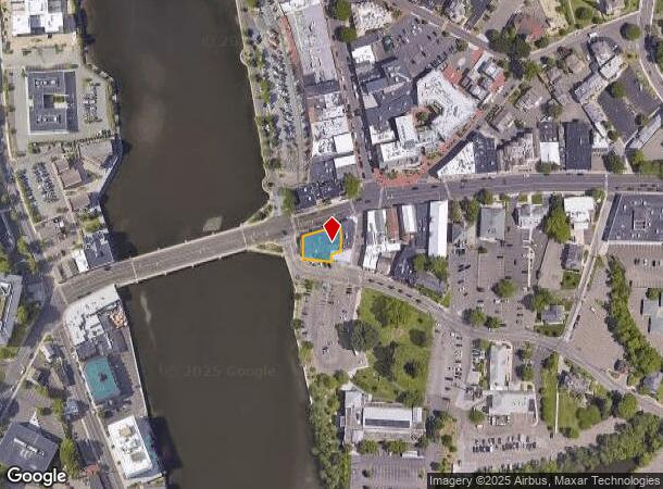
2 Post Rd E, Westport, CT 06880
NEARBY LISTINGS FOR SALE OR LEASE
Property Detail
2 Post Rd E
WPOR-000009C-000000-000131
Fairfield
Commercialbuilding
Connecticut
AE
131-0
09001C0413G
0.18 AC
2025
Westport
2025
Westchester/So Connecticut
050500
Bridgeport-Stamford-Norwalk, CT
13,034 SF
DEMOGRAPHICS near 2 Post Rd E
1 Mile
3 Mile
5 Mile
2024 Total Population
5,922
48,397
128,386
2029 Population
5,945
48,675
128,638
Pop Growth 2024-2029
+ 0.39%
+ 0.57%
+ 0.20%
Average Age
41
42
41
2024 Total Households
2,132
17,928
48,873
HH Growth 2024-2029
+ 0.33%
+ 0.53%
+ 0.19%
Median Household Inc
$209,123
$154,086
$116,806
Avg Household Size
2.70
2.60
2.60
2024 Avg HH Vehicles
2.00
2.00
2.00
Median Home Value
$1,060,275
$827,155
$693,512
Median Year Built
1962
1965
1966
Nearby Places
Map Layers
Map Styles
 Street
 Aerial
- Restaurants
- Banks
- Shops
- Fitness
- Groceries
PUBLIC TRANSPORTATION
COMMUTER RAIL
Westport Station (New Haven Line - Metro-North Commuter Railroad Company (Metro-North))
DRIVE
WALK
Distance
Westport Station (New Haven Line - Metro-North Commuter Railroad Company (Metro-North))
5 min
2.1 mi
Green's Farms Station (New Haven Line - Metro-North Commuter Railroad Company (Metro-North))
DRIVE
WALK
Distance
Green's Farms Station (New Haven Line - Metro-North Commuter Railroad Company (Metro-North))
8 min
3.5 mi
AIRPORT
Westchester County
DRIVE
WALK
Distance
Westchester County
39 min
25.4 mi
Tweed/New Haven
DRIVE
WALK
Distance
Tweed/New Haven
51 min
33.7 mi
Freight Ports
Port of New Haven
DRIVE
WALK
Distance
Port of New Haven
46 min
30.8 mi
SALE & LEASE HISTORY
LISTING DATE
SALE/LEASE

Aug 22, 2018
For Lease
Nearby Properties
Address
Land Use
TOTAL SIZE
Lot Size
Zoning
Address
Land Use
TOTAL SIZE
Lot Size
Zoning
50.42 AC
DDD4
Address
Land Use
TOTAL SIZE
Lot Size
Zoning
6.80 AC
B2
Address
Land Use
TOTAL SIZE
Lot Size
Zoning
226,920 SF
24.75 AC
B
Address
Land Use
TOTAL SIZE
Lot Size
Zoning
27.33 AC
AAA
Address
Land Use
TOTAL SIZE
Lot Size
Zoning
269,100 SF
38.37 AC
RI
Address
Land Use
TOTAL SIZE
Lot Size
Zoning
252,316 SF
Address
Land Use
TOTAL SIZE
Lot Size
Zoning
1.44 AC
BCD/H
Address
Land Use
TOTAL SIZE
Lot Size
Zoning
101,688 SF
5 AC
RI
Address
Land Use
TOTAL SIZE
Lot Size
Zoning
272.25 AC
AAA
Address
Land Use
TOTAL SIZE
Lot Size
Zoning
45.06 AC
AAA
Address
Land Use
TOTAL SIZE
Lot Size
Zoning
13.10 AC
RBD
Address
Land Use
TOTAL SIZE
Lot Size
Zoning
29.50 AC
DOSRD1
Address
Land Use
TOTAL SIZE
Lot Size
Zoning
23.15 AC
A
Address
Land Use
TOTAL SIZE
Lot Size
Zoning
12.30 AC
AA
Address
Land Use
TOTAL SIZE
Lot Size
Zoning
165,384 SF
18.78 AC
B
Address
Land Use
TOTAL SIZE
Lot Size
Zoning
168.95 AC
AAA_AA
Address
Land Use
TOTAL SIZE
Lot Size
Zoning
23.87 AC
A
Address
Land Use
TOTAL SIZE
Lot Size
Zoning
24.82 AC
AA_A
Address
Land Use
TOTAL SIZE
Lot Size
Zoning
90,056 SF
28.10 AC
AA_A
Address
Land Use
TOTAL SIZE
Lot Size
Zoning
20.91 AC
A1
Address
Land Use
TOTAL SIZE
Lot Size
Zoning
37.21 AC
RI
Address
Land Use
TOTAL SIZE
Lot Size
Zoning
10.55 AC
AA
Address
Land Use
TOTAL SIZE
Lot Size
Zoning
54,143 SF
2.75 AC
B
Address
Land Use
TOTAL SIZE
Lot Size
Zoning
7.13 AC
B
Address
Land Use
TOTAL SIZE
Lot Size
Zoning
94,449 SF
5.40 AC
BPD/A
Address
Land Use
TOTAL SIZE
Lot Size
Zoning
10.37 AC
B2
Address
Land Use
TOTAL SIZE
Lot Size
Zoning
118,795 SF
15.60 AC
B2
Address
Land Use
TOTAL SIZE
Lot Size
Zoning
21.93 AC
DDD4
Address
Land Use
TOTAL SIZE
Lot Size
Zoning
99,778 SF
Address
Land Use
TOTAL SIZE
Lot Size
Zoning
134.24 AC
A3
The World's #1 Commercial Real Estate Marketplace
Connect with us
© 2025 CoStar Group
The information above has been obtained from sources believed reliable. While we do not doubt its accuracy we have not verified it and make no guarantee, warranty or representation about it. It is your responsibility to independently confirm its accuracy and completeness. Any projections, opinions, assumptions, or estimates used are for example only and do not represent the current or future performance of the property. The value of this transaction to you depends on tax and other factors which should be evaluated by your tax, financial, and legal advisors. You and your advisors should conduct a careful, independent investigation of the property to determine to your satisfaction the suitability of the property for your needs.