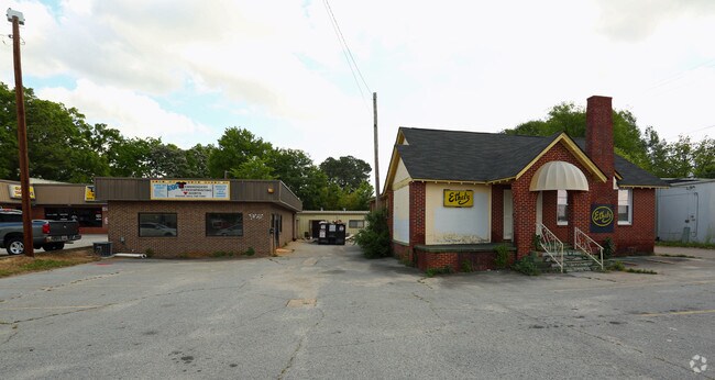
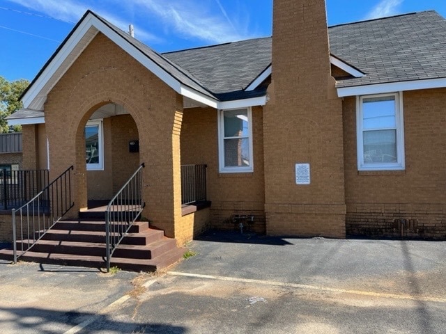
Property Record
1620 Broad River Rd, Columbia, SC 29210


Property Detail
1620 Broad River Rd
07308-02-14
LOTS 1 2 BLOCK A 108X185.5X98X186.5 #SU ELM-ABODE F-147 53-6517
Commercialnec
Richland
RAC
South Carolina
B and X Area of moderate flood hazard, usually the area between the limits of the 100-year and 500-year floods.
1-2
2025
0.46 AC
2024
St Andrews
010412
Columbia
2,062 SF
Columbia, SC
NEARBY LISTINGS FOR SALE OR LEASE
DEMOGRAPHICS near 1620 Broad River Rd
1 mile
3 mile
5 mile
2025 Total Population
8,470
59,642
153,911
2030 Population
8,750
61,972
160,242
Pop Growth 2025-2030
+ 3.31%
+ 3.91%
+ 4.11%
Average Age
35
38
37
2025 Total Households
4,439
27,730
65,591
HH Growth 2025-2030
+ 3.38%
+ 4.15%
+ 4.47%
Median Household Inc
$44,000
$51,134
$49,785
Avg Household Size
1.90
2.00
2.10
2025 Avg HH Vehicles
1.00
1.00
1.00
Median Home Value
$151,811
$200,638
$201,870
Median Year Built
1979
1976
1975
Nearby Places
Map Layers
Map Styles
 Street
 Aerial
Transit
 Traffic
 Biking
Places
Listings with unknown addresses are not visible on the map
- Restaurants
- Banks
- Shops
- Fitness
- Groceries
PUBLIC TRANSPORTATION
COMMUTER RAIL
Columbia Amtrak Station (Silver Star - Amtrak)
Drive
Walk
Distance
Columbia Amtrak Station (Silver Star - Amtrak)
9 min
4.6 mi
AIRPORT
Columbia Metro
Drive
Walk
Distance
Columbia Metro
23 min
11.2 mi
Freight Ports
North Charleston Terminal
Drive
Walk
Distance
North Charleston Terminal
122 min
107.5 mi
SALE & LEASE HISTORY
LISTING DATE
SALE/LEASE

Nov 02, 2022
For Lease
Aug 15, 2017
For Lease
Nearby Properties
Address
Land Use
TOTAL SIZE
Lot Size
Zoning
Address
Land Use
TOTAL SIZE
Lot Size
Zoning
119,738 SF
10.30 AC
EC
Address
Land Use
TOTAL SIZE
Lot Size
Zoning
128,160 SF
9.31 AC
RM-HD
Address
Land Use
TOTAL SIZE
Lot Size
Zoning
358,561 SF
42.10 AC
EC
Address
Land Use
TOTAL SIZE
Lot Size
Zoning
128,877 SF
24.71 AC
RM-HD
Address
Land Use
TOTAL SIZE
Lot Size
Zoning
9,620 SF
18.91 AC
GC
Address
Land Use
TOTAL SIZE
Lot Size
Zoning
183,392 SF
14.77 AC
RM-HD
Address
Land Use
TOTAL SIZE
Lot Size
Zoning
66,720 SF
19.20 AC
RM-2
Address
Land Use
TOTAL SIZE
Lot Size
Zoning
300,130 SF
7.56 AC
RAC
Address
Land Use
TOTAL SIZE
Lot Size
Zoning
290,324 SF
38.74 AC
RM-2
Address
Land Use
TOTAL SIZE
Lot Size
Zoning
278,912 SF
23.24 AC
RM-HD
Address
Land Use
TOTAL SIZE
Lot Size
Zoning
232,600 SF
17.65 AC
RM-2
Address
Land Use
TOTAL SIZE
Lot Size
Zoning
207,112 SF
16.86 AC
RM-HD
Address
Land Use
TOTAL SIZE
Lot Size
Zoning
245,506 SF
14.13 AC
GC
Address
Land Use
TOTAL SIZE
Lot Size
Zoning
220,568 SF
14.53 AC
RM-2
Address
Land Use
TOTAL SIZE
Lot Size
Zoning
231,468 SF
17.41 AC
RM-2
Address
Land Use
TOTAL SIZE
Lot Size
Zoning
237,885 SF
20.76 AC
RM-2
Address
Land Use
TOTAL SIZE
Lot Size
Zoning
161,636 SF
12.38 AC
RM-HD
Address
Land Use
TOTAL SIZE
Lot Size
Zoning
208,688 SF
13.02 AC
RM-HD
Address
Land Use
TOTAL SIZE
Lot Size
Zoning
247,360 SF
6.61 AC
EC
Address
Land Use
TOTAL SIZE
Lot Size
Zoning
2,268 SF
27.70 AC
RM-1
Address
Land Use
TOTAL SIZE
Lot Size
Zoning
171,284 SF
10.50 AC
RG-2
Address
Land Use
TOTAL SIZE
Lot Size
Zoning
129,108 SF
11.90 AC
RM-HD
Address
Land Use
TOTAL SIZE
Lot Size
Zoning
195,550 SF
17.19 AC
GC
Address
Land Use
TOTAL SIZE
Lot Size
Zoning
169,278 SF
12.21 AC
RM-HD
Address
Land Use
TOTAL SIZE
Lot Size
Zoning
153,272 SF
9.63 AC
RM-HD
Address
Land Use
TOTAL SIZE
Lot Size
Zoning
100 SF
465.41 AC
INS-GEN
Address
Land Use
TOTAL SIZE
Lot Size
Zoning
192,966 SF
13.23 AC
RM-HD
Address
Land Use
TOTAL SIZE
Lot Size
Zoning
127,063 SF
14.70 AC
RM-HD
Address
Land Use
TOTAL SIZE
Lot Size
Zoning
34,393 SF
2.96 AC
M-1
Address
Land Use
TOTAL SIZE
Lot Size
Zoning
204,968 SF
17.39 AC
RM-HD
The World's #1 Commercial Real Estate Marketplace
Connect with us
© 2026 CoStar Group
The information above has been obtained from sources believed reliable. While we do not doubt its accuracy we have not verified it and make no guarantee, warranty or representation about it. It is your responsibility to independently confirm its accuracy and completeness. Any projections, opinions, assumptions, or estimates used are for example only and do not represent the current or future performance of the property. The value of this transaction to you depends on tax and other factors which should be evaluated by your tax, financial, and legal advisors. You and your advisors should conduct a careful, independent investigation of the property to determine to your satisfaction the suitability of the property for your needs.