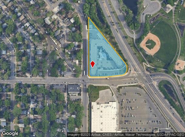
Property Record
3600 France Ave N, Minneapolis, MN 55422

NEARBY LISTINGS FOR SALE OR LEASE
Property Detail
3600 France Ave N
Minneapolis-St. Paul-Bloomington, MN-WI
Parker Station Flats
05-029-24-33-0027
LOT 001 BLOCK 001 B PARKER STATION FLATS IRREGULAR
Apartment
Hennepin
X
Minnesota
27053C0214F
1
2024
2.55 AC
2024
Crystal Lake
021300
Minneapolis/St Paul
DEMOGRAPHICS near 3600 France Ave N
1 Mile
3 Mile
5 Mile
2024 Total Population
17,178
122,084
366,916
2029 Population
16,832
119,408
362,207
Pop Growth 2024-2029
(2.01%)
(2.19%)
(1.28%)
Average Age
40
37
38
2024 Total Households
7,062
45,650
160,598
HH Growth 2024-2029
(2.04%)
(2.34%)
(1.22%)
Median Household Inc
$71,763
$65,637
$70,045
Avg Household Size
2.30
2.50
2.20
2024 Avg HH Vehicles
2.00
2.00
1.00
Median Home Value
$249,119
$246,777
$277,171
Median Year Built
1951
1956
1965
Nearby Places
Map Layers
Map Styles
 Street
 Aerial
- Restaurants
- Banks
- Shops
- Fitness
- Groceries
PUBLIC TRANSPORTATION
COMMUTER RAIL
Target Field Station (Northstar Corridor - Northstar Commuter Rail)
DRIVE
WALK
Distance
Target Field Station (Northstar Corridor - Northstar Commuter Rail)
12 min
4.3 mi
Fridley Station (Northstar Corridor - Northstar Commuter Rail)
DRIVE
WALK
Distance
Fridley Station (Northstar Corridor - Northstar Commuter Rail)
12 min
6.6 mi
AIRPORT
Minneapolis-St Paul International/Wold-Chamberlain
DRIVE
WALK
Distance
Minneapolis-St Paul International/Wold-Chamberlain
30 min
20.5 mi
Nearby Properties
Address
Land Use
TOTAL SIZE
Lot Size
Zoning
Address
Land Use
TOTAL SIZE
Lot Size
Zoning
1 SF
69.72 AC
I3
Address
Land Use
TOTAL SIZE
Lot Size
Zoning
Address
Land Use
TOTAL SIZE
Lot Size
Zoning
229,978 SF
2.43 AC
C3A
Address
Land Use
TOTAL SIZE
Lot Size
Zoning
Address
Land Use
TOTAL SIZE
Lot Size
Zoning
351,351 SF
17.98 AC
Address
Land Use
TOTAL SIZE
Lot Size
Zoning
19.10 AC
Address
Land Use
TOTAL SIZE
Lot Size
Zoning
Address
Land Use
TOTAL SIZE
Lot Size
Zoning
14.04 AC
Address
Land Use
TOTAL SIZE
Lot Size
Zoning
255,324 SF
15.22 AC
Address
Land Use
TOTAL SIZE
Lot Size
Zoning
276,211 SF
2.57 AC
I1
Address
Land Use
TOTAL SIZE
Lot Size
Zoning
Address
Land Use
TOTAL SIZE
Lot Size
Zoning
Address
Land Use
TOTAL SIZE
Lot Size
Zoning
4.34 AC
Address
Land Use
TOTAL SIZE
Lot Size
Zoning
Address
Land Use
TOTAL SIZE
Lot Size
Zoning
Address
Land Use
TOTAL SIZE
Lot Size
Zoning
161,560 SF
1.09 AC
C2
Address
Land Use
TOTAL SIZE
Lot Size
Zoning
9.89 AC
Address
Land Use
TOTAL SIZE
Lot Size
Zoning
51,421 SF
60.40 AC
I2
Address
Land Use
TOTAL SIZE
Lot Size
Zoning
138,649 SF
1.09 AC
C1
Address
Land Use
TOTAL SIZE
Lot Size
Zoning
10.31 AC
Address
Land Use
TOTAL SIZE
Lot Size
Zoning
72.58 AC
Address
Land Use
TOTAL SIZE
Lot Size
Zoning
10.31 AC
Address
Land Use
TOTAL SIZE
Lot Size
Zoning
133,908 SF
1.21 AC
R5
Address
Land Use
TOTAL SIZE
Lot Size
Zoning
15.54 AC
Address
Land Use
TOTAL SIZE
Lot Size
Zoning
10.21 AC
Address
Land Use
TOTAL SIZE
Lot Size
Zoning
3.18 AC
Address
Land Use
TOTAL SIZE
Lot Size
Zoning
202,752 SF
12.62 AC
Address
Land Use
TOTAL SIZE
Lot Size
Zoning
35,774 SF
5.56 AC
R4
Address
Land Use
TOTAL SIZE
Lot Size
Zoning
117,110 SF
12.86 AC
The World's #1 Commercial Real Estate Marketplace
Connect with us
© 2025 CoStar Group
The information above has been obtained from sources believed reliable. While we do not doubt its accuracy we have not verified it and make no guarantee, warranty or representation about it. It is your responsibility to independently confirm its accuracy and completeness. Any projections, opinions, assumptions, or estimates used are for example only and do not represent the current or future performance of the property. The value of this transaction to you depends on tax and other factors which should be evaluated by your tax, financial, and legal advisors. You and your advisors should conduct a careful, independent investigation of the property to determine to your satisfaction the suitability of the property for your needs.