Property Record
1348 S 13Th St, Decatur, IN 46733

Property Detail
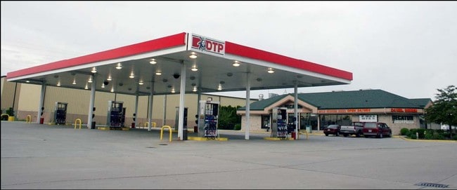
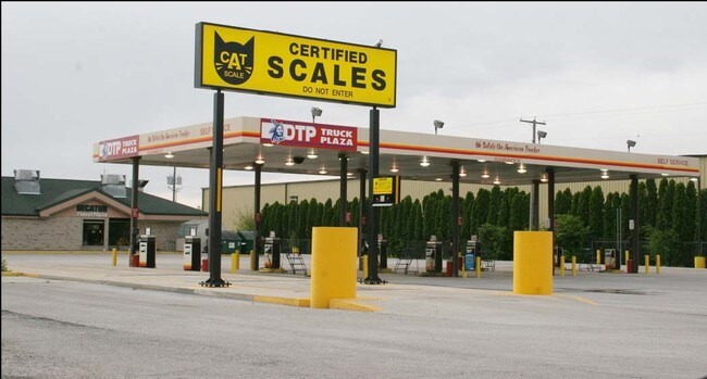
1348 S 13Th St
Conveniencestore
S 180' OF E 655' OF N/2 NE SEC 9 (2.704A)
C2
Adams
B and X Area of moderate flood hazard, usually the area between the limits of the 100-year and 500-year floods.
Indiana
2025
2.70 AC
2025
Other Market Areas
030200
Decatur, IN
4,739 SF
01-05-09-200-030.000-022
NEARBY LISTINGS FOR SALE OR LEASE
DEMOGRAPHICS near 1348 S 13Th St
1 mile
3 mile
5 mile
2025 Total Population
2,549
12,324
16,540
2030 Population
2,596
12,624
16,915
Pop Growth 2025-2030
+ 1.84%
+ 2.43%
+ 2.27%
Average Age
41
41
40
2025 Total Households
1,067
5,125
6,621
HH Growth 2025-2030
+ 1.78%
+ 2.30%
+ 2.17%
Median Household Inc
$42,962
$58,006
$61,151
Avg Household Size
2.30
2.30
2.40
2025 Avg HH Vehicles
2.00
2.00
2.00
Median Home Value
$149,608
$160,802
$173,148
Median Year Built
1966
1967
1968
Nearby Places
Map Layers
Map Styles
 Street
 Aerial
Layers
 Traffic
 Biking
Places
Listings with unknown addresses are not visible on the map
- Restaurants
- Banks
- Shops
- Fitness
- Groceries
PUBLIC TRANSPORTATION
AIRPORT
Fort Wayne International
Drive
Walk
Distance
Fort Wayne International
42 min
25.0 mi
Nearby Properties
Address
Land Use
TOTAL SIZE
Lot Size
Zoning
Address
Land Use
TOTAL SIZE
Lot Size
Zoning
562,416 SF
41.95 AC
I2
Address
Land Use
TOTAL SIZE
Lot Size
Zoning
184,013 SF
24.19 AC
R1
Address
Land Use
TOTAL SIZE
Lot Size
Zoning
329,238 SF
90.71 AC
R1
Address
Land Use
TOTAL SIZE
Lot Size
Zoning
1,792 SF
51.96 AC
Address
Land Use
TOTAL SIZE
Lot Size
Zoning
202,677 SF
39.93 AC
I1
Address
Land Use
TOTAL SIZE
Lot Size
Zoning
9,960 SF
11.01 AC
C2
Address
Land Use
TOTAL SIZE
Lot Size
Zoning
68,134 SF
20.05 AC
Address
Land Use
TOTAL SIZE
Lot Size
Zoning
107,341 SF
9.79 AC
Address
Land Use
TOTAL SIZE
Lot Size
Zoning
99,971 SF
24.32 AC
Address
Land Use
TOTAL SIZE
Lot Size
Zoning
11,526 SF
13.41 AC
Address
Land Use
TOTAL SIZE
Lot Size
Zoning
13,308 SF
19.84 AC
Address
Land Use
TOTAL SIZE
Lot Size
Zoning
27,444 SF
1.20 AC
Address
Land Use
TOTAL SIZE
Lot Size
Zoning
186,674 SF
17.53 AC
I2
Address
Land Use
TOTAL SIZE
Lot Size
Zoning
152,564 SF
21.25 AC
I2
Address
Land Use
TOTAL SIZE
Lot Size
Zoning
43,308 SF
0.19 AC
Address
Land Use
TOTAL SIZE
Lot Size
Zoning
128,675 SF
10.60 AC
I2
Address
Land Use
TOTAL SIZE
Lot Size
Zoning
1,032 SF
6.41 AC
R1
Address
Land Use
TOTAL SIZE
Lot Size
Zoning
6,528 SF
2.87 AC
Address
Land Use
TOTAL SIZE
Lot Size
Zoning
1,340 SF
226.05 AC
Address
Land Use
TOTAL SIZE
Lot Size
Zoning
56,997 SF
5 AC
Address
Land Use
TOTAL SIZE
Lot Size
Zoning
76,542 SF
25.26 AC
I1
Address
Land Use
TOTAL SIZE
Lot Size
Zoning
45,328 SF
10.03 AC
Address
Land Use
TOTAL SIZE
Lot Size
Zoning
20,394 SF
10 AC
R1
Address
Land Use
TOTAL SIZE
Lot Size
Zoning
43,169 SF
0.20 AC
Address
Land Use
TOTAL SIZE
Lot Size
Zoning
6,000 SF
7.70 AC
Address
Land Use
TOTAL SIZE
Lot Size
Zoning
34,992 SF
13.27 AC
Address
Land Use
TOTAL SIZE
Lot Size
Zoning
28,132 SF
2 AC
C2
Address
Land Use
TOTAL SIZE
Lot Size
Zoning
0.90 AC
Address
Land Use
TOTAL SIZE
Lot Size
Zoning
12,612 SF
0.24 AC
Address
Land Use
TOTAL SIZE
Lot Size
Zoning
100,595 SF
22.43 AC
The World's #1 Commercial Real Estate Marketplace
Connect with us
© 2026 CoStar Group
The information above has been obtained from sources believed reliable. While we do not doubt its accuracy we have not verified it and make no guarantee, warranty or representation about it. It is your responsibility to independently confirm its accuracy and completeness. Any projections, opinions, assumptions, or estimates used are for example only and do not represent the current or future performance of the property. The value of this transaction to you depends on tax and other factors which should be evaluated by your tax, financial, and legal advisors. You and your advisors should conduct a careful, independent investigation of the property to determine to your satisfaction the suitability of the property for your needs.