Property Record
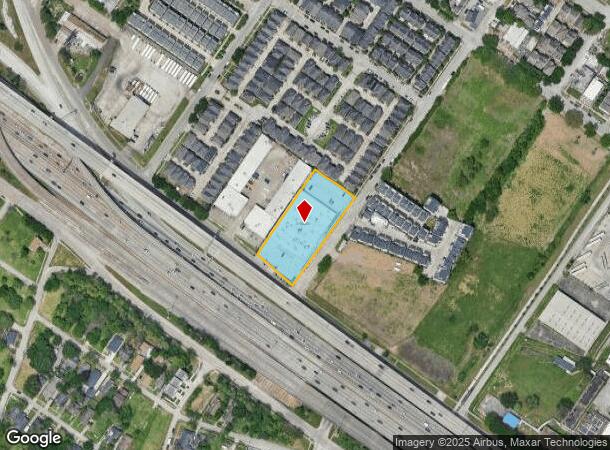
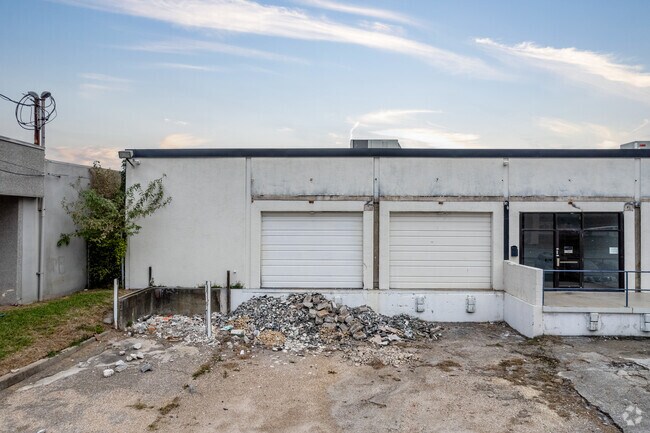
2955 Gulf Fwy, Houston, TX 77003


NEARBY LISTINGS FOR SALE OR LEASE
Property Detail
2955 Gulf Fwy
0410310040013
Abst 75 H Tierwester
Storebuilding
TR 8A ABST 75 H TIERWESTER
X
Harris
48201C0880M
Texas
2024
1.31 AC
2025
Inner Loop East End
310200
Houston
28,564 SF
Houston-Pasadena-The Woodlands, TX
DEMOGRAPHICS near 2955 Gulf Fwy
1 Mile
3 Mile
5 Mile
2024 Total Population
17,766
190,904
481,661
2029 Population
18,783
199,129
499,816
Pop Growth 2024-2029
+ 5.72%
+ 4.31%
+ 3.77%
Average Age
37
37
37
2024 Total Households
8,372
84,098
208,937
HH Growth 2024-2029
+ 5.64%
+ 4.75%
+ 4.06%
Median Household Inc
$59,824
$68,688
$67,242
Avg Household Size
2.00
1.90
2.10
2024 Avg HH Vehicles
1.00
1.00
2.00
Median Home Value
$346,471
$355,171
$354,246
Median Year Built
2005
1995
1987
Nearby Places
Map Layers
Map Styles
 Street
 Aerial
- Restaurants
- Banks
- Shops
- Fitness
- Groceries
PUBLIC TRANSPORTATION
COMMUTER RAIL
DRIVE
WALK
Distance
7 min
2.8 mi
AIRPORT
William P Hobby
DRIVE
WALK
Distance
William P Hobby
22 min
10.7 mi
George Bush Intcntl/Houston
DRIVE
WALK
Distance
George Bush Intcntl/Houston
29 min
20.0 mi
SALE & LEASE HISTORY
LISTING DATE
SALE/LEASE

Jun 13, 2018
For Lease
Feb 25, 2020
For Lease
Nearby Properties
Address
Land Use
TOTAL SIZE
Lot Size
Zoning
Address
Land Use
TOTAL SIZE
Lot Size
Zoning
1,383,720 SF
1.47 AC
Address
Land Use
TOTAL SIZE
Lot Size
Zoning
1,101,686 SF
1.45 AC
Address
Land Use
TOTAL SIZE
Lot Size
Zoning
973,861 SF
1.18 AC
Address
Land Use
TOTAL SIZE
Lot Size
Zoning
899,279 SF
1.18 AC
Address
Land Use
TOTAL SIZE
Lot Size
Zoning
797,208 SF
1.46 AC
Address
Land Use
TOTAL SIZE
Lot Size
Zoning
1,916,394 SF
1.46 AC
Address
Land Use
TOTAL SIZE
Lot Size
Zoning
1,871,418 SF
1.44 AC
Address
Land Use
TOTAL SIZE
Lot Size
Zoning
1,091,726 SF
2.60 AC
Address
Land Use
TOTAL SIZE
Lot Size
Zoning
1,232,364 SF
1.49 AC
Address
Land Use
TOTAL SIZE
Lot Size
Zoning
1,436,400 SF
1.44 AC
Address
Land Use
TOTAL SIZE
Lot Size
Zoning
1,321,033 SF
1.46 AC
Address
Land Use
TOTAL SIZE
Lot Size
Zoning
4,169,721 SF
31.23 AC
Address
Land Use
TOTAL SIZE
Lot Size
Zoning
2,005,097 SF
1.44 AC
Address
Land Use
TOTAL SIZE
Lot Size
Zoning
1,374,271 SF
1.44 AC
Address
Land Use
TOTAL SIZE
Lot Size
Zoning
1,150,681 SF
1.17 AC
Address
Land Use
TOTAL SIZE
Lot Size
Zoning
515,025 SF
1.50 AC
Address
Land Use
TOTAL SIZE
Lot Size
Zoning
1,657,484 SF
1.44 AC
Address
Land Use
TOTAL SIZE
Lot Size
Zoning
1,282,908 SF
2.74 AC
Address
Land Use
TOTAL SIZE
Lot Size
Zoning
1,311,133 SF
1.44 AC
Address
Land Use
TOTAL SIZE
Lot Size
Zoning
1,181,384 SF
1.47 AC
Address
Land Use
TOTAL SIZE
Lot Size
Zoning
1,162,204 SF
1.44 AC
Address
Land Use
TOTAL SIZE
Lot Size
Zoning
934,258 SF
1.45 AC
Address
Land Use
TOTAL SIZE
Lot Size
Zoning
1,103,424 SF
1.44 AC
Address
Land Use
TOTAL SIZE
Lot Size
Zoning
1,365,801 SF
1.44 AC
Address
Land Use
TOTAL SIZE
Lot Size
Zoning
1,017,783 SF
1.44 AC
Address
Land Use
TOTAL SIZE
Lot Size
Zoning
1,182,525 SF
1.11 AC
Address
Land Use
TOTAL SIZE
Lot Size
Zoning
608,233 SF
2.23 AC
Address
Land Use
TOTAL SIZE
Lot Size
Zoning
930,730 SF
1.89 AC
Address
Land Use
TOTAL SIZE
Lot Size
Zoning
612,078 SF
1.44 AC
Address
Land Use
TOTAL SIZE
Lot Size
Zoning
468,513 SF
0.86 AC
The World's #1 Commercial Real Estate Marketplace
Connect with us
© 2026 CoStar Group
The information above has been obtained from sources believed reliable. While we do not doubt its accuracy we have not verified it and make no guarantee, warranty or representation about it. It is your responsibility to independently confirm its accuracy and completeness. Any projections, opinions, assumptions, or estimates used are for example only and do not represent the current or future performance of the property. The value of this transaction to you depends on tax and other factors which should be evaluated by your tax, financial, and legal advisors. You and your advisors should conduct a careful, independent investigation of the property to determine to your satisfaction the suitability of the property for your needs.