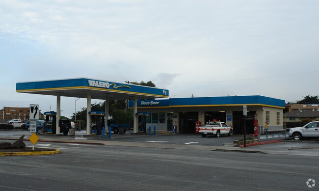
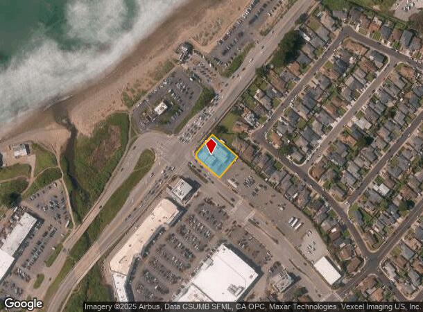
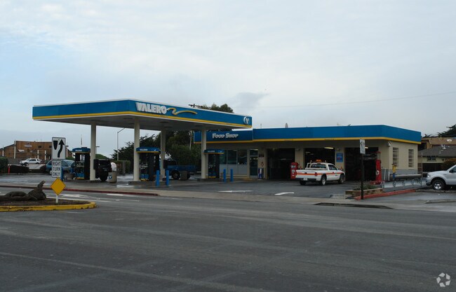
Property Record
505 Linda Mar Blvd, Pacifica, CA 94044
NEARBY LISTINGS FOR SALE OR LEASE
Property Detail
505 Linda Mar Blvd
San Francisco-Redwood City-South San Francisco, CA
Linda Mar No 7
022-192-190
LOT 12 BLOCK 25 LINDA MAR NO 7 RSM 38/5
Commercialnec
San Mateo
AH
California
06081C0107F
12
2024
0.42 AC
2025
Peninsula Coastline
603200
San Francisco
DEMOGRAPHICS near 505 Linda Mar Blvd
1 Mile
3 Mile
5 Mile
2024 Total Population
6,383
21,544
97,236
2029 Population
6,044
20,459
92,065
Pop Growth 2024-2029
(5.31%)
(5.04%)
(5.32%)
Average Age
44
45
44
2024 Total Households
2,338
8,163
34,166
HH Growth 2024-2029
(5.60%)
(5.24%)
(5.58%)
Median Household Inc
$134,344
$135,435
$132,233
Avg Household Size
2.70
2.60
2.70
2024 Avg HH Vehicles
2.00
2.00
2.00
Median Home Value
$1,092,879
$1,093,405
$1,082,336
Median Year Built
1958
1964
1967
Nearby Places
Map Layers
Map Styles
 Street
 Aerial
- Restaurants
- Banks
- Shops
- Fitness
- Groceries
PUBLIC TRANSPORTATION
COMMUTER RAIL
San Bruno Caltrain Station (Local - Caltrain (Caltrain), Local Weekday - Caltrain (Caltrain), Local Weekend - Caltrain (Caltrain), LTD 4 - Caltrain (Caltrain))
DRIVE
WALK
Distance
San Bruno Caltrain Station (Local - Caltrain (Caltrain), Local Weekday - Caltrain (Caltrain), Local Weekend - Caltrain (Caltrain), LTD 4 - Caltrain (Caltrain))
15 min
8.4 mi
AIRPORT
San Francisco International
DRIVE
WALK
Distance
San Francisco International
21 min
11.1 mi
Metro Oakland International
DRIVE
WALK
Distance
Metro Oakland International
50 min
35.8 mi
Freight Ports
Port of San Francisco
DRIVE
WALK
Distance
Port of San Francisco
26 min
18.5 mi
Nearby Properties
Address
Land Use
TOTAL SIZE
Lot Size
Zoning
Address
Land Use
TOTAL SIZE
Lot Size
Zoning
58,775 SF
3.04 AC
R30000
Address
Land Use
TOTAL SIZE
Lot Size
Zoning
144,294 SF
12.12 AC
CL00C1
Address
Land Use
TOTAL SIZE
Lot Size
Zoning
73,485 SF
3.94 AC
R30000
Address
Land Use
TOTAL SIZE
Lot Size
Zoning
83,760 SF
1.49 AC
R30000
Address
Land Use
TOTAL SIZE
Lot Size
Zoning
0.75 AC
Address
Land Use
TOTAL SIZE
Lot Size
Zoning
74,279 SF
2.28 AC
R30000
Address
Land Use
TOTAL SIZE
Lot Size
Zoning
74,815 SF
1.70 AC
Address
Land Use
TOTAL SIZE
Lot Size
Zoning
23,940 SF
0.55 AC
CL00C1
Address
Land Use
TOTAL SIZE
Lot Size
Zoning
51,861 SF
1.53 AC
R30000
Address
Land Use
TOTAL SIZE
Lot Size
Zoning
20,408 SF
1.57 AC
CL00C2
Address
Land Use
TOTAL SIZE
Lot Size
Zoning
9.10 AC
PF0000
Address
Land Use
TOTAL SIZE
Lot Size
Zoning
31,630 SF
0.99 AC
Address
Land Use
TOTAL SIZE
Lot Size
Zoning
31,630 SF
0.75 AC
Address
Land Use
TOTAL SIZE
Lot Size
Zoning
6.70 AC
Address
Land Use
TOTAL SIZE
Lot Size
Zoning
34,207 SF
1.72 AC
Address
Land Use
TOTAL SIZE
Lot Size
Zoning
2.63 AC
CL00C2
Address
Land Use
TOTAL SIZE
Lot Size
Zoning
8,239 SF
0.28 AC
Address
Land Use
TOTAL SIZE
Lot Size
Zoning
7.56 AC
00099X
Address
Land Use
TOTAL SIZE
Lot Size
Zoning
9,944 SF
0.34 AC
Address
Land Use
TOTAL SIZE
Lot Size
Zoning
8,312 SF
0.22 AC
Address
Land Use
TOTAL SIZE
Lot Size
Zoning
1,257 SF
171.30 AC
AB0005
Address
Land Use
TOTAL SIZE
Lot Size
Zoning
1.23 AC
Address
Land Use
TOTAL SIZE
Lot Size
Zoning
31,732 SF
0.68 AC
C10000
Address
Land Use
TOTAL SIZE
Lot Size
Zoning
9,987 SF
0.17 AC
Address
Land Use
TOTAL SIZE
Lot Size
Zoning
8,524 SF
0.21 AC
Address
Land Use
TOTAL SIZE
Lot Size
Zoning
16,230 SF
0.36 AC
C10000
Address
Land Use
TOTAL SIZE
Lot Size
Zoning
77,008 SF
6.04 AC
C1000P
Address
Land Use
TOTAL SIZE
Lot Size
Zoning
8,680 SF
0.18 AC
The World's #1 Commercial Real Estate Marketplace
Connect with us
© 2025 CoStar Group
The information above has been obtained from sources believed reliable. While we do not doubt its accuracy we have not verified it and make no guarantee, warranty or representation about it. It is your responsibility to independently confirm its accuracy and completeness. Any projections, opinions, assumptions, or estimates used are for example only and do not represent the current or future performance of the property. The value of this transaction to you depends on tax and other factors which should be evaluated by your tax, financial, and legal advisors. You and your advisors should conduct a careful, independent investigation of the property to determine to your satisfaction the suitability of the property for your needs.