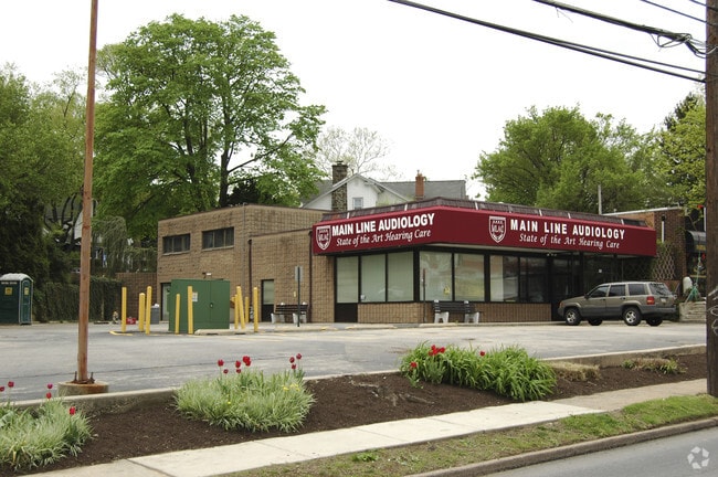
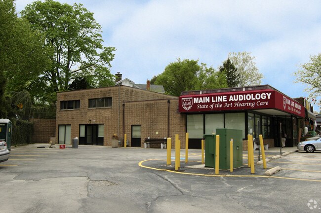
Property Record
916 Montgomery Ave, Penn Valley, PA 19072


Property Detail
916 Montgomery Ave
12-00-02620-005
INC 12 00 02614 00 2 & 12 00 02617 00 8
Officebuilding
Montgomery
C
Pennsylvania
B and X Area of moderate flood hazard, usually the area between the limits of the 100-year and 500-year floods.
34
2026
0.43 AC
2026
Bala Cynwyd/Narberth
205600
Philadelphia
5,505 SF
Philadelphia-Camden-Wilmington, PA-NJ-DE-MD
NEARBY LISTINGS FOR SALE OR LEASE
DEMOGRAPHICS near 916 Montgomery Ave
1 mile
3 mile
5 mile
2025 Total Population
15,267
165,865
539,727
2030 Population
15,598
167,506
544,587
Pop Growth 2025-2030
+ 2.17%
+ 0.99%
+ 0.90%
Average Age
41
40
39
2025 Total Households
5,602
67,966
221,793
HH Growth 2025-2030
+ 2.09%
+ 0.75%
+ 0.80%
Median Household Inc
$192,259
$92,926
$69,517
Avg Household Size
2.60
2.30
2.30
2025 Avg HH Vehicles
2.00
1.00
1.00
Median Home Value
$814,995
$409,013
$321,847
Median Year Built
1948
1950
1948
Nearby Places
Map Layers
Map Styles
 Street
 Aerial
Layers
 Traffic
 Biking
Places
Listings with unknown addresses are not visible on the map
- Restaurants
- Banks
- Shops
- Fitness
- Groceries
PUBLIC TRANSPORTATION
COMMUTER RAIL
Narberth (R5 - Southeastern Pennsylvania Transportation Authority Regional Rail (SEPTA Regional Rail))
Drive
Walk
Distance
Narberth (R5 - Southeastern Pennsylvania Transportation Authority Regional Rail (SEPTA Regional Rail))
2 min
12 min
0.6 mi
Wynnewood (R5 - Southeastern Pennsylvania Transportation Authority Regional Rail (SEPTA Regional Rail))
Drive
Walk
Distance
Wynnewood (R5 - Southeastern Pennsylvania Transportation Authority Regional Rail (SEPTA Regional Rail))
4 min
1.4 mi
AIRPORT
Philadelphia International
Drive
Walk
Distance
Philadelphia International
32 min
15.7 mi
Trenton Mercer
Drive
Walk
Distance
Trenton Mercer
62 min
36.0 mi
Freight Ports
South Jersey Port
Drive
Walk
Distance
South Jersey Port
23 min
11.1 mi
Nearby Properties
Address
Land Use
TOTAL SIZE
Lot Size
Zoning
Address
Land Use
TOTAL SIZE
Lot Size
Zoning
391,885 SF
7.15 AC
RM4
Address
Land Use
TOTAL SIZE
Lot Size
Zoning
2,178,860 SF
48.65 AC
R3
Address
Land Use
TOTAL SIZE
Lot Size
Zoning
291,026 SF
6.80 AC
RSD3
Address
Land Use
TOTAL SIZE
Lot Size
Zoning
451,857 SF
3.57 AC
CMX2
Address
Land Use
TOTAL SIZE
Lot Size
Zoning
1,600 SF
177.07 AC
SPPOA
Address
Land Use
TOTAL SIZE
Lot Size
Zoning
253,400 SF
10.90 AC
RM2
Address
Land Use
TOTAL SIZE
Lot Size
Zoning
368,612 SF
20.06 AC
CMX2
Address
Land Use
TOTAL SIZE
Lot Size
Zoning
511,806 SF
1.70 AC
RM4
Address
Land Use
TOTAL SIZE
Lot Size
Zoning
418,017 SF
19.10 AC
CO
Address
Land Use
TOTAL SIZE
Lot Size
Zoning
702,393 SF
61.81 AC
RA
Address
Land Use
TOTAL SIZE
Lot Size
Zoning
194,304 SF
9.33 AC
RM2
Address
Land Use
TOTAL SIZE
Lot Size
Zoning
409,386 SF
33.36 AC
R2
Address
Land Use
TOTAL SIZE
Lot Size
Zoning
479,520 SF
21.26 AC
R1
Address
Land Use
TOTAL SIZE
Lot Size
Zoning
210,738 SF
8.73 AC
RM4
Address
Land Use
TOTAL SIZE
Lot Size
Zoning
377,851 SF
19.18 AC
R4
Address
Land Use
TOTAL SIZE
Lot Size
Zoning
193,228 SF
18.06 AC
RMX1
Address
Land Use
TOTAL SIZE
Lot Size
Zoning
112,268 SF
28.27 AC
Address
Land Use
TOTAL SIZE
Lot Size
Zoning
281,508 SF
18.93 AC
SPINS
Address
Land Use
TOTAL SIZE
Lot Size
Zoning
299,678 SF
14.06 AC
R4
Address
Land Use
TOTAL SIZE
Lot Size
Zoning
568,410 SF
33.08 AC
RMX1
Address
Land Use
TOTAL SIZE
Lot Size
Zoning
530,525 SF
36.29 AC
R3
Address
Land Use
TOTAL SIZE
Lot Size
Zoning
258,000 SF
1.90 AC
CMX2
Address
Land Use
TOTAL SIZE
Lot Size
Zoning
197,925 SF
1.96 AC
RM4
Address
Land Use
TOTAL SIZE
Lot Size
Zoning
475,984 SF
5.74 AC
ICMX
Address
Land Use
TOTAL SIZE
Lot Size
Zoning
178,738 SF
6.11 AC
CMX3
Address
Land Use
TOTAL SIZE
Lot Size
Zoning
257,405 SF
4.26 AC
C2
Address
Land Use
TOTAL SIZE
Lot Size
Zoning
197,640 SF
3.01 AC
CMX2
Address
Land Use
TOTAL SIZE
Lot Size
Zoning
260,237 SF
3.25 AC
RM2
Address
Land Use
TOTAL SIZE
Lot Size
Zoning
193,740 SF
4.96 AC
SPCIV
Address
Land Use
TOTAL SIZE
Lot Size
Zoning
321,744 SF
14 AC
C1
The World's #1 Commercial Real Estate Marketplace
Connect with us
© 2026 CoStar Group
The information above has been obtained from sources believed reliable. While we do not doubt its accuracy we have not verified it and make no guarantee, warranty or representation about it. It is your responsibility to independently confirm its accuracy and completeness. Any projections, opinions, assumptions, or estimates used are for example only and do not represent the current or future performance of the property. The value of this transaction to you depends on tax and other factors which should be evaluated by your tax, financial, and legal advisors. You and your advisors should conduct a careful, independent investigation of the property to determine to your satisfaction the suitability of the property for your needs.