Property Record
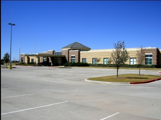
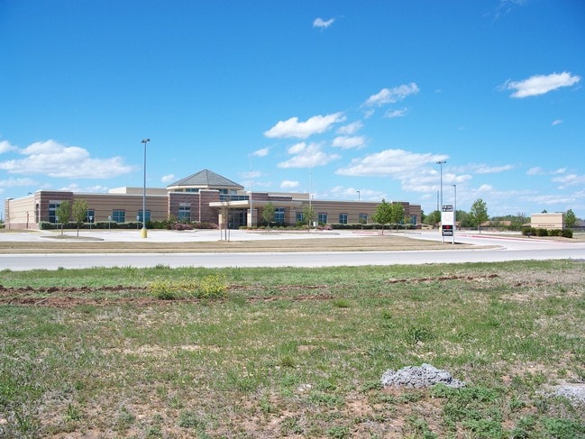
5602 Health Center Dr, Abilene, TX 79606

Property Detail
5602 Health Center Dr
Abilene, TX
MEDICAL PLAZA SUB, BLOCK B, LOT 2, ACRES 10.0
970050
Taylor
Multipleuses
Texas
B and X Area of moderate flood hazard, usually the area between the limits of the 100-year and 500-year floods.
2
2024
10 AC
2025
Abilene
013401
Other Market Areas
39,961 SF
NEARBY LISTINGS FOR SALE OR LEASE
DEMOGRAPHICS near 5602 Health Center Dr
1 mile
3 mile
5 mile
2025 Total Population
8,748
48,482
96,128
2030 Population
9,150
50,591
100,031
Pop Growth 2025-2030
+ 4.60%
+ 4.35%
+ 4.06%
Average Age
32
36
37
2025 Total Households
3,796
19,432
37,352
HH Growth 2025-2030
+ 4.53%
+ 4.38%
+ 4.21%
Median Household Inc
$55,568
$60,128
$59,842
Avg Household Size
2.30
2.40
2.40
2025 Avg HH Vehicles
2.00
2.00
2.00
Median Home Value
$189,543
$188,364
$179,072
Median Year Built
1984
1974
1971
Nearby Places
Map Layers
Map Styles
 Street
 Aerial
Layers
 Traffic
 Biking
Places
Listings with unknown addresses are not visible on the map
- Restaurants
- Banks
- Shops
- Fitness
- Groceries
PUBLIC TRANSPORTATION
AIRPORT
Abilene Regional
Drive
Walk
Distance
Abilene Regional
19 min
11.6 mi
SALE & LEASE HISTORY
LISTING DATE
SALE/LEASE

Sep 25, 2016
For Lease
Sep 24, 2016
For Sale
Mar 06, 2019
For Sale
Nearby Properties
Address
Land Use
TOTAL SIZE
Lot Size
Zoning
Address
Land Use
TOTAL SIZE
Lot Size
Zoning
227.42 AC
Address
Land Use
TOTAL SIZE
Lot Size
Zoning
600,001 SF
39.40 AC
Address
Land Use
TOTAL SIZE
Lot Size
Zoning
183,321 SF
11.67 AC
Address
Land Use
TOTAL SIZE
Lot Size
Zoning
256,877 SF
11.04 AC
Address
Land Use
TOTAL SIZE
Lot Size
Zoning
129,462 SF
69.58 AC
Address
Land Use
TOTAL SIZE
Lot Size
Zoning
421,730 SF
30.12 AC
Address
Land Use
TOTAL SIZE
Lot Size
Zoning
117,207 SF
17.41 AC
Address
Land Use
TOTAL SIZE
Lot Size
Zoning
162,480 SF
9.88 AC
Address
Land Use
TOTAL SIZE
Lot Size
Zoning
143,845 SF
11.47 AC
Address
Land Use
TOTAL SIZE
Lot Size
Zoning
166,901 SF
14.71 AC
Address
Land Use
TOTAL SIZE
Lot Size
Zoning
195,960 SF
11.07 AC
Address
Land Use
TOTAL SIZE
Lot Size
Zoning
182,328 SF
10.93 AC
Address
Land Use
TOTAL SIZE
Lot Size
Zoning
187,944 SF
8.69 AC
Address
Land Use
TOTAL SIZE
Lot Size
Zoning
200,648 SF
8.98 AC
Address
Land Use
TOTAL SIZE
Lot Size
Zoning
6.55 AC
Address
Land Use
TOTAL SIZE
Lot Size
Zoning
195,544 SF
11 AC
Address
Land Use
TOTAL SIZE
Lot Size
Zoning
73,947 SF
9.89 AC
Address
Land Use
TOTAL SIZE
Lot Size
Zoning
79,879 SF
2.86 AC
Address
Land Use
TOTAL SIZE
Lot Size
Zoning
161,050 SF
12.18 AC
Address
Land Use
TOTAL SIZE
Lot Size
Zoning
80,574 SF
4.20 AC
Address
Land Use
TOTAL SIZE
Lot Size
Zoning
121,816 SF
3.06 AC
Address
Land Use
TOTAL SIZE
Lot Size
Zoning
146,819 SF
9.75 AC
Address
Land Use
TOTAL SIZE
Lot Size
Zoning
9.55 AC
Address
Land Use
TOTAL SIZE
Lot Size
Zoning
150,552 SF
9.72 AC
Address
Land Use
TOTAL SIZE
Lot Size
Zoning
210,556 SF
24.67 AC
Address
Land Use
TOTAL SIZE
Lot Size
Zoning
138,432 SF
7.06 AC
Address
Land Use
TOTAL SIZE
Lot Size
Zoning
78,522 SF
41.23 AC
Address
Land Use
TOTAL SIZE
Lot Size
Zoning
140,297 SF
7.99 AC
Address
Land Use
TOTAL SIZE
Lot Size
Zoning
143,931 SF
13.21 AC
Address
Land Use
TOTAL SIZE
Lot Size
Zoning
104,728 SF
17.56 AC
The World's #1 Commercial Real Estate Marketplace
Connect with us
© 2026 CoStar Group
The information above has been obtained from sources believed reliable. While we do not doubt its accuracy we have not verified it and make no guarantee, warranty or representation about it. It is your responsibility to independently confirm its accuracy and completeness. Any projections, opinions, assumptions, or estimates used are for example only and do not represent the current or future performance of the property. The value of this transaction to you depends on tax and other factors which should be evaluated by your tax, financial, and legal advisors. You and your advisors should conduct a careful, independent investigation of the property to determine to your satisfaction the suitability of the property for your needs.