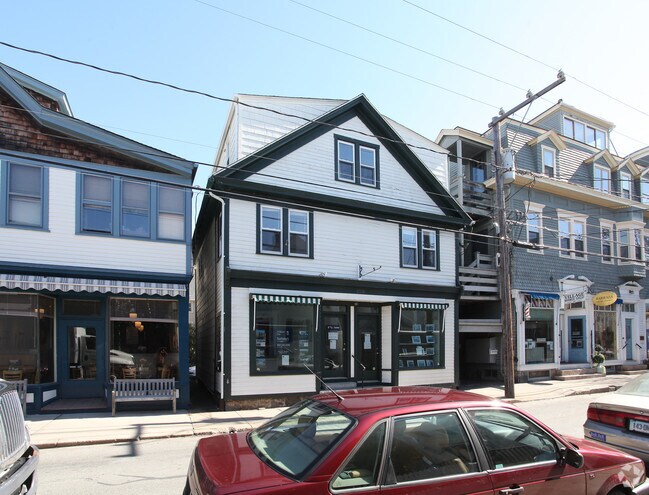
Property Record
109 Water St, Stonington, CT 06378

Property Detail
109 Water St
STON-000101-000019-000002
Southeastern Ct
Commercialbuilding
Connecticut
PC
2
AE The base floodplain where base flood elevations are provided. AE Zones are now used on new format FIRMs instead of A1-A30 Zones.
0.04 AC
2025
SE New London
2025
Hartford
705200
Norwich-New London-Willimantic, CT
2,604 SF
NEARBY LISTINGS FOR SALE OR LEASE
-
-
View all Stonington listings for sale on LoopNet.com
DEMOGRAPHICS near 109 Water St
1 mile
3 mile
5 mile
2025 Total Population
1,727
5,611
30,049
2030 Population
1,794
5,805
30,751
Pop Growth 2025-2030
+ 3.88%
+ 3.46%
+ 2.34%
Average Age
53
51
49
2025 Total Households
926
2,677
13,778
HH Growth 2025-2030
+ 3.78%
+ 3.44%
+ 2.40%
Median Household Inc
$104,629
$115,174
$108,567
Avg Household Size
1.90
2.00
2.10
2025 Avg HH Vehicles
2.00
2.00
2.00
Median Home Value
$736,334
$680,000
$524,981
Median Year Built
1946
1954
1965
Nearby Places
Map Layers
Map Styles
 Street
 Aerial
Layers
 Traffic
 Biking
Places
Listings with unknown addresses are not visible on the map
- Restaurants
- Banks
- Shops
- Fitness
- Groceries
PUBLIC TRANSPORTATION
COMMUTER RAIL
Drive
Walk
Distance
9 min
4.4 mi
Drive
Walk
Distance
12 min
6.1 mi
AIRPORT
Rhode Island Tf Green International
Drive
Walk
Distance
Rhode Island Tf Green International
62 min
43.0 mi
Freight Ports
Port of Davisville, RI
Drive
Walk
Distance
Port of Davisville, RI
63 min
43.3 mi
SALE & LEASE HISTORY
LISTING DATE
SALE/LEASE

Nov 12, 2021
For Sale
Nearby Properties
Address
Land Use
TOTAL SIZE
Lot Size
Zoning
Address
Land Use
TOTAL SIZE
Lot Size
Zoning
32.59 AC
RA-40
Address
Land Use
TOTAL SIZE
Lot Size
Zoning
74,328 SF
19.50 AC
RR-80
Address
Land Use
TOTAL SIZE
Lot Size
Zoning
120,243 SF
9.06 AC
TC-80
Address
Land Use
TOTAL SIZE
Lot Size
Zoning
85,073 SF
17.60 AC
RA-20
Address
Land Use
TOTAL SIZE
Lot Size
Zoning
7.40 AC
M-1
Address
Land Use
TOTAL SIZE
Lot Size
Zoning
1.30 AC
Address
Land Use
TOTAL SIZE
Lot Size
Zoning
68,206 SF
6.40 AC
M-1
Address
Land Use
TOTAL SIZE
Lot Size
Zoning
25.88 AC
RR-80
Address
Land Use
TOTAL SIZE
Lot Size
Zoning
48,697 SF
3.83 AC
TC-80
Address
Land Use
TOTAL SIZE
Lot Size
Zoning
46,652 SF
12.23 AC
RC-120
Address
Land Use
TOTAL SIZE
Lot Size
Zoning
48.70 AC
GB-130
Address
Land Use
TOTAL SIZE
Lot Size
Zoning
7,500 SF
2.87 AC
MC-80
Address
Land Use
TOTAL SIZE
Lot Size
Zoning
3.50 AC
RC-120
Address
Land Use
TOTAL SIZE
Lot Size
Zoning
40,534 SF
20.84 AC
RC-120
Address
Land Use
TOTAL SIZE
Lot Size
Zoning
4.80 AC
RL
Address
Land Use
TOTAL SIZE
Lot Size
Zoning
7.62 AC
RM-20
Address
Land Use
TOTAL SIZE
Lot Size
Zoning
2,616 SF
3.21 AC
RR-80
Address
Land Use
TOTAL SIZE
Lot Size
Zoning
4,004 SF
30.20 AC
GB-130
Address
Land Use
TOTAL SIZE
Lot Size
Zoning
3.80 AC
RM-15
Address
Land Use
TOTAL SIZE
Lot Size
Zoning
71,673 SF
4.30 AC
M-1
Address
Land Use
TOTAL SIZE
Lot Size
Zoning
1.15 AC
MC-80
Address
Land Use
TOTAL SIZE
Lot Size
Zoning
9.70 AC
RC-120
Address
Land Use
TOTAL SIZE
Lot Size
Zoning
12.40 AC
RM-20
Address
Land Use
TOTAL SIZE
Lot Size
Zoning
13,000 SF
11.08 AC
M-1
Address
Land Use
TOTAL SIZE
Lot Size
Zoning
2,204 SF
34.14 AC
RM-15
Address
Land Use
TOTAL SIZE
Lot Size
Zoning
3 AC
RR-80
Address
Land Use
TOTAL SIZE
Lot Size
Zoning
21.96 AC
TC-80
Address
Land Use
TOTAL SIZE
Lot Size
Zoning
25.04 AC
RM-20
Address
Land Use
TOTAL SIZE
Lot Size
Zoning
17,925 SF
5.38 AC
LS-5
Address
Land Use
TOTAL SIZE
Lot Size
Zoning
2.30 AC
RR-80
The World's #1 Commercial Real Estate Marketplace
Connect with us
© 2026 CoStar Group
The information above has been obtained from sources believed reliable. While we do not doubt its accuracy we have not verified it and make no guarantee, warranty or representation about it. It is your responsibility to independently confirm its accuracy and completeness. Any projections, opinions, assumptions, or estimates used are for example only and do not represent the current or future performance of the property. The value of this transaction to you depends on tax and other factors which should be evaluated by your tax, financial, and legal advisors. You and your advisors should conduct a careful, independent investigation of the property to determine to your satisfaction the suitability of the property for your needs.