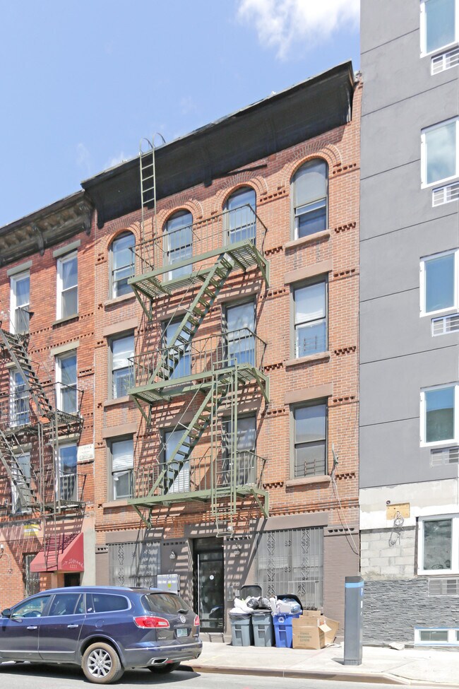
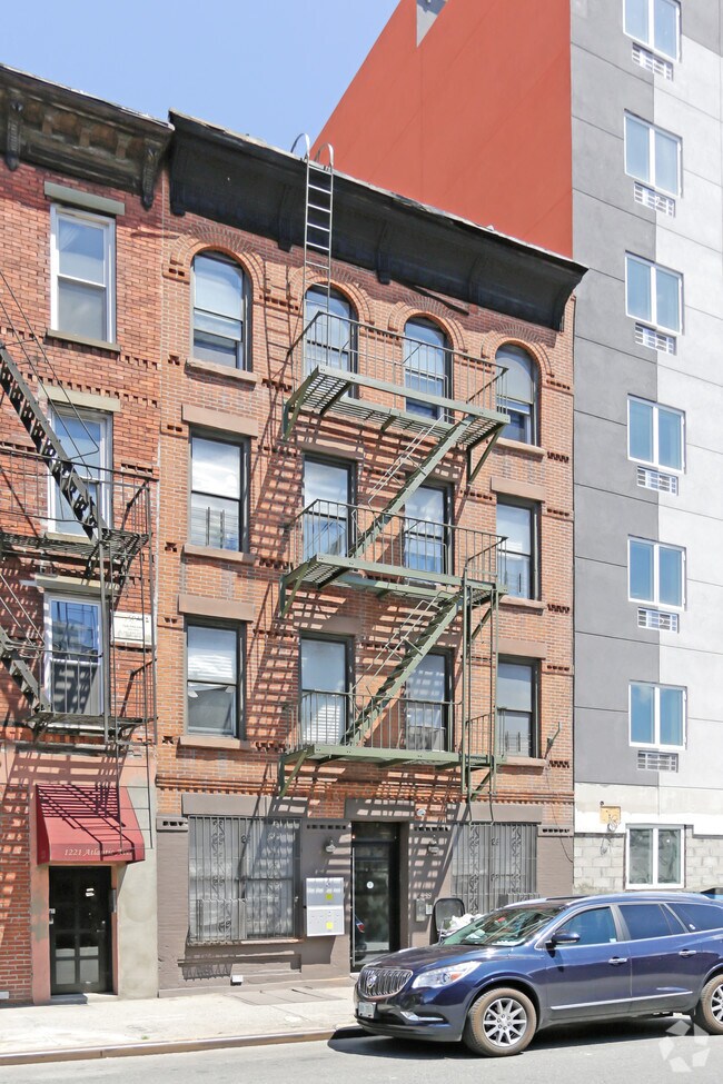
Property Record
54 Herkimer Pl, Brooklyn, NY 11216
NEARBY LISTINGS FOR SALE OR LEASE
Property Detail
54 Herkimer Pl
01866-0022
DOCID-2016052700724001
Multifamilydwelling
Kings
X
New York
3604970212F
22
2024
0.06 AC
2024
Bedford-Stuyvesant
024700
Long Island (New York)
4,500 SF
New York-Jersey City-White Plains, NY-NJ
DEMOGRAPHICS near 54 Herkimer Pl
1 Mile
3 Mile
5 Mile
2024 Total Population
189,613
1,342,158
2,788,281
2029 Population
179,684
1,271,532
2,606,461
Pop Growth 2024-2029
(5.24%)
(5.26%)
(6.52%)
Average Age
38
38
38
2024 Total Households
78,432
523,425
1,085,420
HH Growth 2024-2029
(5.76%)
(5.69%)
(6.77%)
Median Household Inc
$82,938
$75,763
$77,859
Avg Household Size
2.30
2.40
2.40
2024 Avg HH Vehicles
.00
.00
.00
Median Home Value
$1,039,257
$939,583
$858,375
Median Year Built
1947
1948
1948
Nearby Places
- Restaurants
- Banks
- Shops
- Fitness
- Groceries
PUBLIC TRANSPORTATION
TRANSIT/SUBWAY
Nostrand Av (7 Avenue Express - 2 - MTA New York City Transit, 7 Avenue Express - 3 - MTA New York City Transit, 8 Avenue Express - A - MTA New York City Transit, 8 Avenue Local - C - MTA New York City Transit, Lexington Avenue Express - 4 - MTA New York City Transit, Lexington Avenue Express - 5 - MTA New York City Transit)
DRIVE
WALK
Distance
Nostrand Av (7 Avenue Express - 2 - MTA New York City Transit, 7 Avenue Express - 3 - MTA New York City Transit, 8 Avenue Express - A - MTA New York City Transit, 8 Avenue Local - C - MTA New York City Transit, Lexington Avenue Express - 4 - MTA New York City Transit, Lexington Avenue Express - 5 - MTA New York City Transit)
1 min
1 min
0.1 mi
Franklin Av (Franklin Avenue Shuttle - S - MTA New York City Transit)
DRIVE
WALK
Distance
Franklin Av (Franklin Avenue Shuttle - S - MTA New York City Transit)
1 min
7 min
0.4 mi
Kingston-Throop Avs (8 Avenue Express - A - MTA New York City Transit, 8 Avenue Local - C - MTA New York City Transit)
DRIVE
WALK
Distance
Kingston-Throop Avs (8 Avenue Express - A - MTA New York City Transit, 8 Avenue Local - C - MTA New York City Transit)
1 min
9 min
0.5 mi
Nostrand Avenue (3,4 Line) (3 - New York MTA Subway (The Subway), 4 - New York MTA Subway (The Subway))
DRIVE
WALK
Distance
Nostrand Avenue (3,4 Line) (3 - New York MTA Subway (The Subway), 4 - New York MTA Subway (The Subway))
2 min
13 min
0.7 mi
Park Pl (Franklin Avenue Shuttle - S - MTA New York City Transit)
DRIVE
WALK
Distance
Park Pl (Franklin Avenue Shuttle - S - MTA New York City Transit)
4 min
15 min
0.8 mi
COMMUTER RAIL
Nostrand Avenue (Babylon Branch - - Long Island Rail Road, Far Rockaway Branch - - Long Island Rail Road, Long Beach Branch - - Long Island Rail Road, Port Jefferson Branch - - Long Island Rail Road, West Hempstead Branch - - Long Island Rail Road)
DRIVE
WALK
Distance
Nostrand Avenue (Babylon Branch - - Long Island Rail Road, Far Rockaway Branch - - Long Island Rail Road, Long Beach Branch - - Long Island Rail Road, Port Jefferson Branch - - Long Island Rail Road, West Hempstead Branch - - Long Island Rail Road)
0 min
3 min
0.2 mi
Atlantic Terminal (Babylon Branch - Long Island Rail Road, City Terminal Zone - Long Island Rail Road, Hempstead Branch - Long Island Rail Road, West Hempstead Branch - Long Island Rail Road)
DRIVE
WALK
Distance
Atlantic Terminal (Babylon Branch - Long Island Rail Road, City Terminal Zone - Long Island Rail Road, Hempstead Branch - Long Island Rail Road, West Hempstead Branch - Long Island Rail Road)
4 min
1.5 mi
AIRPORT
LaGuardia
DRIVE
WALK
Distance
LaGuardia
20 min
10.4 mi
John F Kennedy International
DRIVE
WALK
Distance
John F Kennedy International
23 min
10.9 mi
Newark Liberty International
DRIVE
WALK
Distance
Newark Liberty International
29 min
16.8 mi
Freight Ports
NY - Red Hook Container Terminal
DRIVE
WALK
Distance
NY - Red Hook Container Terminal
11 min
3.5 mi
Nearby Properties
Address
Land Use
TOTAL SIZE
Lot Size
Zoning
Address
Land Use
TOTAL SIZE
Lot Size
Zoning
2,812,739 SF
2.10 AC
C5-3
Address
Land Use
TOTAL SIZE
Lot Size
Zoning
7,064,736 SF
147.61 AC
M3-1
Address
Land Use
TOTAL SIZE
Lot Size
Zoning
92,440 SF
466.23 AC
R5
Address
Land Use
TOTAL SIZE
Lot Size
Zoning
1,503,150 SF
20.47 AC
R5
Address
Land Use
TOTAL SIZE
Lot Size
Zoning
393.54 AC
PARK
Address
Land Use
TOTAL SIZE
Lot Size
Zoning
577,381 SF
3.19 AC
R6
Address
Land Use
TOTAL SIZE
Lot Size
Zoning
942,992 SF
2.22 AC
R7-1
Address
Land Use
TOTAL SIZE
Lot Size
Zoning
2,948,300 SF
27.71 AC
R7-2
Address
Land Use
TOTAL SIZE
Lot Size
Zoning
1,330,743 SF
2.20 AC
C6-4
Address
Land Use
TOTAL SIZE
Lot Size
Zoning
296,915 SF
0.31 AC
C5-3
Address
Land Use
TOTAL SIZE
Lot Size
Zoning
830,879 SF
1 AC
C5-4
Address
Land Use
TOTAL SIZE
Lot Size
Zoning
383,249 SF
1.32 AC
R6
Address
Land Use
TOTAL SIZE
Lot Size
Zoning
835,231 SF
11.32 AC
R6
Address
Land Use
TOTAL SIZE
Lot Size
Zoning
449,695 SF
0.60 AC
C6-2
Address
Land Use
TOTAL SIZE
Lot Size
Zoning
869,038 SF
1.53 AC
M1-1
Address
Land Use
TOTAL SIZE
Lot Size
Zoning
1,061,228 SF
8.86 AC
R5
Address
Land Use
TOTAL SIZE
Lot Size
Zoning
579,404 SF
11.20 AC
R6
Address
Land Use
TOTAL SIZE
Lot Size
Zoning
790,392 SF
0.74 AC
M1-1
Address
Land Use
TOTAL SIZE
Lot Size
Zoning
561,945 SF
11.58 AC
R6
Address
Land Use
TOTAL SIZE
Lot Size
Zoning
589,750 SF
1.19 AC
R6
Address
Land Use
TOTAL SIZE
Lot Size
Zoning
662,532 SF
1.21 AC
C6-4
Address
Land Use
TOTAL SIZE
Lot Size
Zoning
978,544 SF
1.60 AC
C61A
Address
Land Use
TOTAL SIZE
Lot Size
Zoning
370,363 SF
0.34 AC
C6-4
Address
Land Use
TOTAL SIZE
Lot Size
Zoning
392,162 SF
1.86 AC
M3-1
Address
Land Use
TOTAL SIZE
Lot Size
Zoning
667,250 SF
1.06 AC
C64.5
Address
Land Use
TOTAL SIZE
Lot Size
Zoning
629,064 SF
0.99 AC
C6-4
Address
Land Use
TOTAL SIZE
Lot Size
Zoning
522,608 SF
1.64 AC
R8
Address
Land Use
TOTAL SIZE
Lot Size
Zoning
450,516 SF
2.32 AC
C6-4
Address
Land Use
TOTAL SIZE
Lot Size
Zoning
725,991 SF
1.05 AC
C6-4
Address
Land Use
TOTAL SIZE
Lot Size
Zoning
600,000 SF
2.51 AC
R6B
The World's #1 Commercial Real Estate Marketplace
Connect with us
© 2025 CoStar Group
The information above has been obtained from sources believed reliable. While we do not doubt its accuracy we have not verified it and make no guarantee, warranty or representation about it. It is your responsibility to independently confirm its accuracy and completeness. Any projections, opinions, assumptions, or estimates used are for example only and do not represent the current or future performance of the property. The value of this transaction to you depends on tax and other factors which should be evaluated by your tax, financial, and legal advisors. You and your advisors should conduct a careful, independent investigation of the property to determine to your satisfaction the suitability of the property for your needs.