Property Record
6100 Debra Rd, Chattanooga, TN 37411
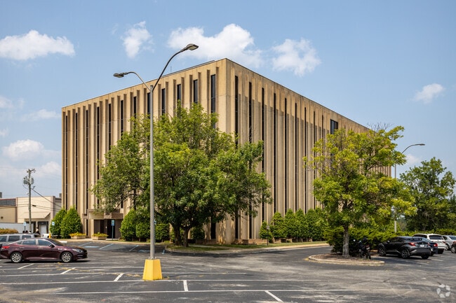

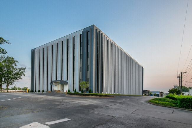
Property Detail
6100 Debra Rd
157M-A-008
LT 1 OSBORNE ENTERPRISES INC SUB PB101 PG132
Officebuilding
HAMILTON
C2
Tennessee
C and X Area of minimal flood hazard, usually depicted on FIRMs as above the 500-year flood level.
1
2025
3.06 AC
2025
Outlying Chattanooga
002900
Chattanooga
83,325 SF
Chattanooga, TN-GA
NEARBY LISTINGS FOR SALE OR LEASE
DEMOGRAPHICS near 6100 Debra Rd
1 mile
3 mile
5 mile
2024 Total Population
3,460
56,273
152,411
2029 Population
3,620
58,756
159,188
Pop Growth 2024-2029
+ 4.62%
+ 4.41%
+ 4.45%
Average Age
39
41
40
2024 Total Households
1,507
24,471
62,816
HH Growth 2024-2029
+ 4.71%
+ 4.56%
+ 4.54%
Median Household Inc
$48,032
$57,595
$59,887
Avg Household Size
2.20
2.20
2.30
2024 Avg HH Vehicles
2.00
2.00
2.00
Median Home Value
$227,215
$241,237
$250,471
Median Year Built
1961
1968
1973
Nearby Places
Map Layers
Map Styles
 Street
 Aerial
Transit
 Traffic
 Biking
Places
Listings with unknown addresses are not visible on the map
- Restaurants
- Banks
- Shops
- Fitness
- Groceries
PUBLIC TRANSPORTATION
AIRPORT
Lovell Field
Drive
Walk
Distance
Lovell Field
9 min
2.1 mi
SALE & LEASE HISTORY
LISTING DATE
SALE/LEASE

Sep 25, 2016
For Lease
Jun 23, 2017
For Lease
Aug 14, 2017
For Lease
Nearby Properties
Address
Land Use
TOTAL SIZE
Lot Size
Zoning
Address
Land Use
TOTAL SIZE
Lot Size
Zoning
831.19 AC
M1
Address
Land Use
TOTAL SIZE
Lot Size
Zoning
292,309 SF
45.28 AC
M1
Address
Land Use
TOTAL SIZE
Lot Size
Zoning
117,007 SF
23.87 AC
R4
Address
Land Use
TOTAL SIZE
Lot Size
Zoning
43,488 SF
27.72 AC
R3
Address
Land Use
TOTAL SIZE
Lot Size
Zoning
25,436 SF
21.34 AC
R3
Address
Land Use
TOTAL SIZE
Lot Size
Zoning
20,964 SF
17.72 AC
R1
Address
Land Use
TOTAL SIZE
Lot Size
Zoning
15,808 SF
19.50 AC
R2
Address
Land Use
TOTAL SIZE
Lot Size
Zoning
4,390 SF
36.30 AC
R3
Address
Land Use
TOTAL SIZE
Lot Size
Zoning
181,612 SF
14.10 AC
Address
Land Use
TOTAL SIZE
Lot Size
Zoning
790,207 SF
53.84 AC
C2
Address
Land Use
TOTAL SIZE
Lot Size
Zoning
176.54 AC
R1
Address
Land Use
TOTAL SIZE
Lot Size
Zoning
21,280 SF
7.67 AC
Address
Land Use
TOTAL SIZE
Lot Size
Zoning
18,360 SF
9.60 AC
R3
Address
Land Use
TOTAL SIZE
Lot Size
Zoning
85,068 SF
9.57 AC
Address
Land Use
TOTAL SIZE
Lot Size
Zoning
27,144 SF
5.62 AC
R3
Address
Land Use
TOTAL SIZE
Lot Size
Zoning
19,600 SF
14.10 AC
UR
Address
Land Use
TOTAL SIZE
Lot Size
Zoning
88,285 SF
7 AC
R3
Address
Land Use
TOTAL SIZE
Lot Size
Zoning
67,735 SF
17.32 AC
M1
Address
Land Use
TOTAL SIZE
Lot Size
Zoning
209,168 SF
23.28 AC
C2
Address
Land Use
TOTAL SIZE
Lot Size
Zoning
135,954 SF
11.83 AC
R3
Address
Land Use
TOTAL SIZE
Lot Size
Zoning
15,968 SF
9.50 AC
Address
Land Use
TOTAL SIZE
Lot Size
Zoning
66,027 SF
2.84 AC
C2
Address
Land Use
TOTAL SIZE
Lot Size
Zoning
151,314 SF
6.60 AC
Address
Land Use
TOTAL SIZE
Lot Size
Zoning
77,975 SF
11.93 AC
C2
Address
Land Use
TOTAL SIZE
Lot Size
Zoning
35,740 SF
5.20 AC
R2
Address
Land Use
TOTAL SIZE
Lot Size
Zoning
7,680 SF
11.06 AC
Address
Land Use
TOTAL SIZE
Lot Size
Zoning
7,352 SF
7.40 AC
R3
Address
Land Use
TOTAL SIZE
Lot Size
Zoning
68,060 SF
6.17 AC
R2
Address
Land Use
TOTAL SIZE
Lot Size
Zoning
81,827 SF
8.84 AC
Address
Land Use
TOTAL SIZE
Lot Size
Zoning
71,458 SF
19.22 AC
M2
The World's #1 Commercial Real Estate Marketplace
Connect with us
© 2026 CoStar Group
The information above has been obtained from sources believed reliable. While we do not doubt its accuracy we have not verified it and make no guarantee, warranty or representation about it. It is your responsibility to independently confirm its accuracy and completeness. Any projections, opinions, assumptions, or estimates used are for example only and do not represent the current or future performance of the property. The value of this transaction to you depends on tax and other factors which should be evaluated by your tax, financial, and legal advisors. You and your advisors should conduct a careful, independent investigation of the property to determine to your satisfaction the suitability of the property for your needs.