Property Record
1016 Sw 6Th Ave, Topeka, KS 66606
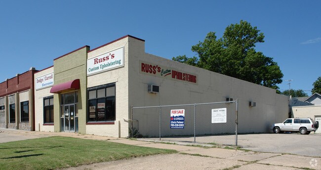


Property Detail
1016 Sw 6Th Ave
109-31-0-20-15-013-000
ORIGINAL TOWN, S31, T11, R16, LOT 134 +, ACRES 0.33, SIXTH AVE WEST 1/2 VACATED ALLEY & ALL LOTS 134-136-138-140
Officebuilding
Shawnee
X1
Kansas
B and X Area of moderate flood hazard, usually the area between the limits of the 100-year and 500-year floods.
134
2024
0.33 AC
2025
Topeka
000600
Kansas City
8,392 SF
Topeka, KS
NEARBY LISTINGS FOR SALE OR LEASE
DEMOGRAPHICS near 1016 Sw 6Th Ave
1 mile
3 mile
5 mile
2025 Total Population
12,380
62,051
122,328
2030 Population
12,694
62,695
122,566
Pop Growth 2025-2030
+ 2.54%
+ 1.04%
+ 0.19%
Average Age
39
40
40
2025 Total Households
5,497
26,431
51,940
HH Growth 2025-2030
+ 2.82%
+ 1.08%
+ 0.17%
Median Household Inc
$42,456
$48,371
$54,786
Avg Household Size
2.10
2.20
2.20
2025 Avg HH Vehicles
1.00
2.00
2.00
Median Home Value
$87,878
$106,823
$141,309
Median Year Built
1948
1953
1965
Nearby Places
Map Layers
Map Styles
 Street
 Aerial
Transit
 Traffic
 Biking
Places
Listings with unknown addresses are not visible on the map
- Restaurants
- Banks
- Shops
- Fitness
- Groceries
PUBLIC TRANSPORTATION
COMMUTER RAIL
Drive
Walk
Distance
3 min
1.3 mi
Nearby Properties
Address
Land Use
TOTAL SIZE
Lot Size
Zoning
Address
Land Use
TOTAL SIZE
Lot Size
Zoning
249,598 SF
150.21 AC
U1
Address
Land Use
TOTAL SIZE
Lot Size
Zoning
513,835 SF
13.39 AC
M1
Address
Land Use
TOTAL SIZE
Lot Size
Zoning
52,453 SF
17.12 AC
C5,OI2
Address
Land Use
TOTAL SIZE
Lot Size
Zoning
309,298 SF
7.34 AC
M1
Address
Land Use
TOTAL SIZE
Lot Size
Zoning
117,839 SF
121.95 AC
R1
Address
Land Use
TOTAL SIZE
Lot Size
Zoning
64,058 SF
3.31 AC
C4,OI2
Address
Land Use
TOTAL SIZE
Lot Size
Zoning
336,669 SF
58.82 AC
PUD,C4
Address
Land Use
TOTAL SIZE
Lot Size
Zoning
3.31 AC
OI2
Address
Land Use
TOTAL SIZE
Lot Size
Zoning
77,776 SF
10.64 AC
PUD,M2,R1,
Address
Land Use
TOTAL SIZE
Lot Size
Zoning
80,630 SF
107.16 AC
R1
Address
Land Use
TOTAL SIZE
Lot Size
Zoning
285,005 SF
3.10 AC
C4,C5,I1
Address
Land Use
TOTAL SIZE
Lot Size
Zoning
19,120 SF
2.08 AC
R1
Address
Land Use
TOTAL SIZE
Lot Size
Zoning
65,687 SF
7.47 AC
C2,I1,M2
Address
Land Use
TOTAL SIZE
Lot Size
Zoning
137,637 SF
10.43 AC
M2
Address
Land Use
TOTAL SIZE
Lot Size
Zoning
90,929 SF
8.68 AC
PUD,OI3,I1
Address
Land Use
TOTAL SIZE
Lot Size
Zoning
114,523 SF
6.92 AC
OI3
Address
Land Use
TOTAL SIZE
Lot Size
Zoning
98,898 SF
1.91 AC
C5
Address
Land Use
TOTAL SIZE
Lot Size
Zoning
107,592 SF
14.98 AC
C4,I1,OI2
Address
Land Use
TOTAL SIZE
Lot Size
Zoning
94,830 SF
17.09 AC
PUD,M4
Address
Land Use
TOTAL SIZE
Lot Size
Zoning
127,947 SF
7.12 AC
C5
Address
Land Use
TOTAL SIZE
Lot Size
Zoning
123,795 SF
16.45 AC
PUD,R1,I1,
Address
Land Use
TOTAL SIZE
Lot Size
Zoning
54,654 SF
0.56 AC
C5
Address
Land Use
TOTAL SIZE
Lot Size
Zoning
112,413 SF
0.73 AC
C5
Address
Land Use
TOTAL SIZE
Lot Size
Zoning
129,425 SF
96.26 AC
R1
Address
Land Use
TOTAL SIZE
Lot Size
Zoning
101,766 SF
2.39 AC
C5,I1
Address
Land Use
TOTAL SIZE
Lot Size
Zoning
101,166 SF
3.31 AC
C5
Address
Land Use
TOTAL SIZE
Lot Size
Zoning
22,484 SF
75.33 AC
R1
Address
Land Use
TOTAL SIZE
Lot Size
Zoning
52,261 SF
4.59 AC
OI3
Address
Land Use
TOTAL SIZE
Lot Size
Zoning
161,335 SF
37.32 AC
R1
Address
Land Use
TOTAL SIZE
Lot Size
Zoning
32,838 SF
3.25 AC
MS1
The World's #1 Commercial Real Estate Marketplace
Connect with us
© 2026 CoStar Group
The information above has been obtained from sources believed reliable. While we do not doubt its accuracy we have not verified it and make no guarantee, warranty or representation about it. It is your responsibility to independently confirm its accuracy and completeness. Any projections, opinions, assumptions, or estimates used are for example only and do not represent the current or future performance of the property. The value of this transaction to you depends on tax and other factors which should be evaluated by your tax, financial, and legal advisors. You and your advisors should conduct a careful, independent investigation of the property to determine to your satisfaction the suitability of the property for your needs.