Property Record
1285 Joseph E Boone Blvd Nw, Atlanta, GA 30314

NEARBY LISTINGS FOR SALE OR LEASE
Property Detail
1285 Joseph E Boone Blvd Nw
14-0143-0010-025-4
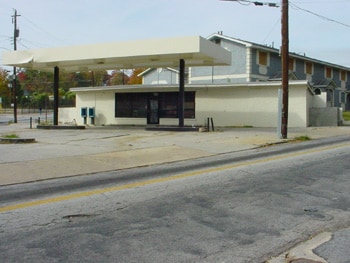
KA FINA SERVICE STATION SO 1993 AN VACANT SERVICE STATION, PUMPS REMOVED
Storebuilding
Fulton
X
Georgia
13121C0243F
143
2024
0.14 AC
2025
Chattahoochee
008400
Atlanta
755 SF
Atlanta-Sandy Springs-Roswell, GA
DEMOGRAPHICS near 1285 Joseph E Boone Blvd Nw
1 Mile
3 Mile
5 Mile
2024 Total Population
15,400
149,354
353,448
2029 Population
16,614
156,488
368,632
Pop Growth 2024-2029
+ 7.88%
+ 4.78%
+ 4.30%
Average Age
39
35
36
2024 Total Households
6,383
65,201
162,598
HH Growth 2024-2029
+ 8.08%
+ 5.23%
+ 4.52%
Median Household Inc
$31,658
$58,817
$71,501
Avg Household Size
2.20
1.90
2.00
2024 Avg HH Vehicles
1.00
1.00
1.00
Median Home Value
$215,866
$317,146
$394,321
Median Year Built
1965
1999
1988
Nearby Places
Map Layers
Map Styles
 Street
 Aerial
- Restaurants
- Banks
- Shops
- Fitness
- Groceries
PUBLIC TRANSPORTATION
TRANSIT/SUBWAY
Bankhead (Green Line - Metropolitan Atlanta Rapid Transit Authority (MARTA))
DRIVE
WALK
Distance
Bankhead (Green Line - Metropolitan Atlanta Rapid Transit Authority (MARTA))
2 min
17 min
0.9 mi
Ashby (Blue Line - Metropolitan Atlanta Rapid Transit Authority (MARTA), Green Line - Metropolitan Atlanta Rapid Transit Authority (MARTA))
DRIVE
WALK
Distance
Ashby (Blue Line - Metropolitan Atlanta Rapid Transit Authority (MARTA), Green Line - Metropolitan Atlanta Rapid Transit Authority (MARTA))
2 min
20 min
1.0 mi
COMMUTER RAIL
DRIVE
WALK
Distance
10 min
5.1 mi
AIRPORT
Hartsfield - Jackson Atlanta International
DRIVE
WALK
Distance
Hartsfield - Jackson Atlanta International
21 min
12.3 mi
Nearby Properties
Address
Land Use
TOTAL SIZE
Lot Size
Zoning
Address
Land Use
TOTAL SIZE
Lot Size
Zoning
19.94 AC
SPI1
Address
Land Use
TOTAL SIZE
Lot Size
Zoning
1,585,451 SF
1.97 AC
SPI2
Address
Land Use
TOTAL SIZE
Lot Size
Zoning
9.80 AC
C5
Address
Land Use
TOTAL SIZE
Lot Size
Zoning
3.16 AC
SPI1
Address
Land Use
TOTAL SIZE
Lot Size
Zoning
9 AC
C5
Address
Land Use
TOTAL SIZE
Lot Size
Zoning
10.27 AC
C5
Address
Land Use
TOTAL SIZE
Lot Size
Zoning
1,039,831 SF
0.31 AC
C4
Address
Land Use
TOTAL SIZE
Lot Size
Zoning
1,227,912 SF
2.15 AC
SPI4
Address
Land Use
TOTAL SIZE
Lot Size
Zoning
1,736,017 SF
3.63 AC
SPI2
Address
Land Use
TOTAL SIZE
Lot Size
Zoning
1,300,309 SF
4.81 AC
SPI1
Address
Land Use
TOTAL SIZE
Lot Size
Zoning
1,434,872 SF
1.89 AC
SPI1
Address
Land Use
TOTAL SIZE
Lot Size
Zoning
61.57 AC
C5
Address
Land Use
TOTAL SIZE
Lot Size
Zoning
1,467,469 SF
0.07 AC
C4
Address
Land Use
TOTAL SIZE
Lot Size
Zoning
10,954,869 SF
28.88 AC
C3
Address
Land Use
TOTAL SIZE
Lot Size
Zoning
1.55 AC
SPI1
Address
Land Use
TOTAL SIZE
Lot Size
Zoning
342,275 SF
0.70 AC
SPI3
Address
Land Use
TOTAL SIZE
Lot Size
Zoning
1,314,183 SF
2.61 AC
SPI1
Address
Land Use
TOTAL SIZE
Lot Size
Zoning
2,577,342 SF
2.04 AC
SPI1
Address
Land Use
TOTAL SIZE
Lot Size
Zoning
13,340,229 SF
3.68 AC
SPI1
Address
Land Use
TOTAL SIZE
Lot Size
Zoning
415,551 SF
1.13 AC
C4
Address
Land Use
TOTAL SIZE
Lot Size
Zoning
883,867 SF
2.71 AC
C1
Address
Land Use
TOTAL SIZE
Lot Size
Zoning
899,982 SF
2.91 AC
C4
Address
Land Use
TOTAL SIZE
Lot Size
Zoning
787,339 SF
1.16 AC
SPI4
Address
Land Use
TOTAL SIZE
Lot Size
Zoning
519,160 SF
3.92 AC
I2
Address
Land Use
TOTAL SIZE
Lot Size
Zoning
935,056 SF
2.35 AC
SPI3
Address
Land Use
TOTAL SIZE
Lot Size
Zoning
1,589,465 SF
3.41 AC
SPI1
Address
Land Use
TOTAL SIZE
Lot Size
Zoning
2,971,832 SF
5.95 AC
SPI2
Address
Land Use
TOTAL SIZE
Lot Size
Zoning
742,537 SF
1.56 AC
C4
Address
Land Use
TOTAL SIZE
Lot Size
Zoning
3.62 AC
SPI1
Address
Land Use
TOTAL SIZE
Lot Size
Zoning
638,721 SF
3.31 AC
I1
The World's #1 Commercial Real Estate Marketplace
Connect with us
© 2025 CoStar Group
The information above has been obtained from sources believed reliable. While we do not doubt its accuracy we have not verified it and make no guarantee, warranty or representation about it. It is your responsibility to independently confirm its accuracy and completeness. Any projections, opinions, assumptions, or estimates used are for example only and do not represent the current or future performance of the property. The value of this transaction to you depends on tax and other factors which should be evaluated by your tax, financial, and legal advisors. You and your advisors should conduct a careful, independent investigation of the property to determine to your satisfaction the suitability of the property for your needs.