Property Record
2210 Silvernail Rd, Pewaukee, WI 53072


NEARBY LISTINGS FOR SALE OR LEASE
Property Detail
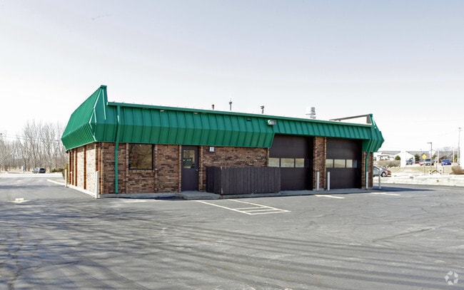
2210 Silvernail Rd
WAKC-0974-002
Certified Survey Map
Commercialnec
CERTIFIED SURVEY MAP NO 3879 V30 CERTIFIED SURVEY MAPS P70 PT NW1/4 SEC 28 T7N R19E 1.01 AC DOC NO 4718691
X
Waukesha
55133C0192H
Wisconsin
2024
1 AC
2024
Central Waukesha
202800
Milwaukee/Madison
1,848 SF
Milwaukee-Waukesha-West Allis, WI
DEMOGRAPHICS near 2210 Silvernail Rd
1 Mile
3 Mile
5 Mile
2024 Total Population
7,022
48,287
109,128
2029 Population
7,225
49,816
112,538
Pop Growth 2024-2029
+ 2.89%
+ 3.17%
+ 3.12%
Average Age
42
42
41
2024 Total Households
3,036
21,296
46,394
HH Growth 2024-2029
+ 2.54%
+ 3.23%
+ 3.22%
Median Household Inc
$85,817
$76,468
$79,197
Avg Household Size
2.20
2.20
2.30
2024 Avg HH Vehicles
2.00
2.00
2.00
Median Home Value
$293,047
$278,018
$285,945
Median Year Built
1991
1983
1980
Nearby Places
Map Layers
Map Styles
 Street
 Aerial
- Restaurants
- Banks
- Shops
- Fitness
- Groceries
PUBLIC TRANSPORTATION
AIRPORT
General Mitchell International
DRIVE
WALK
Distance
General Mitchell International
37 min
24.5 mi
Freight Ports
Port Milwaukee
DRIVE
WALK
Distance
Port Milwaukee
30 min
21.0 mi
Nearby Properties
Address
Land Use
TOTAL SIZE
Lot Size
Zoning
Address
Land Use
TOTAL SIZE
Lot Size
Zoning
25.92 AC
Address
Land Use
TOTAL SIZE
Lot Size
Zoning
172.13 AC
M-2
Address
Land Use
TOTAL SIZE
Lot Size
Zoning
Address
Land Use
TOTAL SIZE
Lot Size
Zoning
56.81 AC
Address
Land Use
TOTAL SIZE
Lot Size
Zoning
Address
Land Use
TOTAL SIZE
Lot Size
Zoning
68,591 SF
2.97 AC
RM-3(PUD)
Address
Land Use
TOTAL SIZE
Lot Size
Zoning
Address
Land Use
TOTAL SIZE
Lot Size
Zoning
63,482 SF
39.53 AC
I-1
Address
Land Use
TOTAL SIZE
Lot Size
Zoning
51,676 SF
7.41 AC
RM-3(PUD)
Address
Land Use
TOTAL SIZE
Lot Size
Zoning
51,676 SF
6.96 AC
RM-3(PUD)
Address
Land Use
TOTAL SIZE
Lot Size
Zoning
129,059 SF
19.19 AC
RM-2(PUD)
Address
Land Use
TOTAL SIZE
Lot Size
Zoning
Address
Land Use
TOTAL SIZE
Lot Size
Zoning
91,322 SF
8.48 AC
B-4
Address
Land Use
TOTAL SIZE
Lot Size
Zoning
110,992 SF
12.15 AC
RM-1(PUD)
Address
Land Use
TOTAL SIZE
Lot Size
Zoning
20.65 AC
Address
Land Use
TOTAL SIZE
Lot Size
Zoning
61,299 SF
6.59 AC
RM-2(PUD)
Address
Land Use
TOTAL SIZE
Lot Size
Zoning
79,529 SF
23.85 AC
I-1
Address
Land Use
TOTAL SIZE
Lot Size
Zoning
13.99 AC
Address
Land Use
TOTAL SIZE
Lot Size
Zoning
203,208 SF
41.18 AC
B-5,C-1
Address
Land Use
TOTAL SIZE
Lot Size
Zoning
11.54 AC
M-1
Address
Land Use
TOTAL SIZE
Lot Size
Zoning
65,803 SF
15.22 AC
RM-2(PUD),
Address
Land Use
TOTAL SIZE
Lot Size
Zoning
136.33 AC
M-2
Address
Land Use
TOTAL SIZE
Lot Size
Zoning
0.81 AC
B-2
Address
Land Use
TOTAL SIZE
Lot Size
Zoning
47,353 SF
5.41 AC
RM-2(PUD)
Address
Land Use
TOTAL SIZE
Lot Size
Zoning
5.23 AC
Address
Land Use
TOTAL SIZE
Lot Size
Zoning
180,616 SF
10.46 AC
B-5(PUD)
Address
Land Use
TOTAL SIZE
Lot Size
Zoning
11.02 AC
Address
Land Use
TOTAL SIZE
Lot Size
Zoning
36,054 SF
10.62 AC
I-1
Address
Land Use
TOTAL SIZE
Lot Size
Zoning
5.01 AC
Address
Land Use
TOTAL SIZE
Lot Size
Zoning
1.74 AC
RM-3(PUD)
The World's #1 Commercial Real Estate Marketplace
Connect with us
© 2025 CoStar Group
The information above has been obtained from sources believed reliable. While we do not doubt its accuracy we have not verified it and make no guarantee, warranty or representation about it. It is your responsibility to independently confirm its accuracy and completeness. Any projections, opinions, assumptions, or estimates used are for example only and do not represent the current or future performance of the property. The value of this transaction to you depends on tax and other factors which should be evaluated by your tax, financial, and legal advisors. You and your advisors should conduct a careful, independent investigation of the property to determine to your satisfaction the suitability of the property for your needs.