Property Record
18203 Mason Dixon Rd, Hagerstown, MD 21740
NEARBY LISTINGS FOR SALE OR LEASE
Property Detail
18203 Mason Dixon Rd
Hagerstown-Martinsburg, MD-WV
James Golden
13-006458
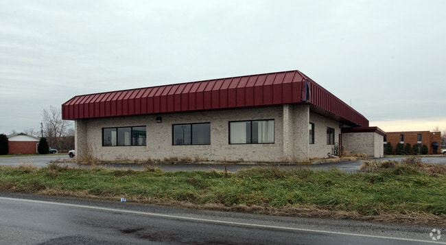
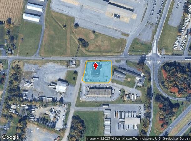
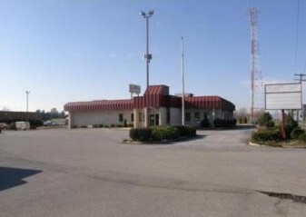
LOT 1 1.243 ACRES 18203 MASON DIXON RD
Restaurantbuilding
Washington
X
Maryland
24043C0130D
1
2024
1.24 AC
2025
Washington County
010402
Washington, DC
7,173 SF
DEMOGRAPHICS near 18203 Mason Dixon Rd
1 Mile
3 Mile
5 Mile
2024 Total Population
1,011
13,846
45,992
2029 Population
1,016
13,865
46,453
Pop Growth 2024-2029
+ 0.49%
+ 0.14%
+ 1.00%
Average Age
39
40
41
2024 Total Households
370
5,191
17,798
HH Growth 2024-2029
+ 0.54%
+ 0.15%
+ 1.06%
Median Household Inc
$70,743
$70,887
$70,864
Avg Household Size
2.70
2.60
2.50
2024 Avg HH Vehicles
2.00
2.00
2.00
Median Home Value
$251,818
$262,104
$249,506
Median Year Built
1977
1982
1976
Nearby Places
Map Layers
Map Styles
 Street
 Aerial
- Restaurants
- Banks
- Shops
- Fitness
- Groceries
PUBLIC TRANSPORTATION
AIRPORT
Hagerstown Regional/Richard A Henson Field
DRIVE
WALK
Distance
Hagerstown Regional/Richard A Henson Field
6 min
2.8 mi
Freight Ports
Port of Baltimore
DRIVE
WALK
Distance
Port of Baltimore
102 min
85.6 mi
Nearby Properties
Address
Land Use
TOTAL SIZE
Lot Size
Zoning
Address
Land Use
TOTAL SIZE
Lot Size
Zoning
1,190,700 SF
83.26 AC
HI
Address
Land Use
TOTAL SIZE
Lot Size
Zoning
23,941 SF
401.89 AC
U
Address
Land Use
TOTAL SIZE
Lot Size
Zoning
801,000 SF
86.86 AC
HI
Address
Land Use
TOTAL SIZE
Lot Size
Zoning
36,685 SF
281.72 AC
IG
Address
Land Use
TOTAL SIZE
Lot Size
Zoning
91,586 SF
28.49 AC
U
Address
Land Use
TOTAL SIZE
Lot Size
Zoning
150,000 SF
22.73 AC
HI
Address
Land Use
TOTAL SIZE
Lot Size
Zoning
764,619 SF
31.10 AC
IG
Address
Land Use
TOTAL SIZE
Lot Size
Zoning
84,796 SF
8.81 AC
PB
Address
Land Use
TOTAL SIZE
Lot Size
Zoning
51,773 SF
11.96 AC
HI
Address
Land Use
TOTAL SIZE
Lot Size
Zoning
36,000 SF
12.07 AC
RM
Address
Land Use
TOTAL SIZE
Lot Size
Zoning
188,784 SF
79.06 AC
AP
Address
Land Use
TOTAL SIZE
Lot Size
Zoning
351,104 SF
55.68 AC
AP
Address
Land Use
TOTAL SIZE
Lot Size
Zoning
6,300 SF
35.92 AC
RT
Address
Land Use
TOTAL SIZE
Lot Size
Zoning
3,024 SF
140 AC
Address
Land Use
TOTAL SIZE
Lot Size
Zoning
12,908 SF
12.94 AC
HI
Address
Land Use
TOTAL SIZE
Lot Size
Zoning
21,483 SF
3.51 AC
HI
Address
Land Use
TOTAL SIZE
Lot Size
Zoning
34,110 SF
8.03 AC
HI
Address
Land Use
TOTAL SIZE
Lot Size
Zoning
135,184 SF
61.18 AC
HI
Address
Land Use
TOTAL SIZE
Lot Size
Zoning
43,600 SF
3.71 AC
HI
Address
Land Use
TOTAL SIZE
Lot Size
Zoning
6,077 SF
8.82 AC
U
Address
Land Use
TOTAL SIZE
Lot Size
Zoning
7.11 AC
PB
Address
Land Use
TOTAL SIZE
Lot Size
Zoning
34,527 SF
2.20 AC
U
Address
Land Use
TOTAL SIZE
Lot Size
Zoning
15.37 AC
U
Address
Land Use
TOTAL SIZE
Lot Size
Zoning
71,306 SF
4.69 AC
HI
Address
Land Use
TOTAL SIZE
Lot Size
Zoning
Address
Land Use
TOTAL SIZE
Lot Size
Zoning
Address
Land Use
TOTAL SIZE
Lot Size
Zoning
15,724 SF
4.48 AC
RM
Address
Land Use
TOTAL SIZE
Lot Size
Zoning
47,020 SF
2.27 AC
BG
Address
Land Use
TOTAL SIZE
Lot Size
Zoning
107,891 SF
8.93 AC
HI
Address
Land Use
TOTAL SIZE
Lot Size
Zoning
42,500 SF
0.25 AC
U
The World's #1 Commercial Real Estate Marketplace
Connect with us
© 2026 CoStar Group
The information above has been obtained from sources believed reliable. While we do not doubt its accuracy we have not verified it and make no guarantee, warranty or representation about it. It is your responsibility to independently confirm its accuracy and completeness. Any projections, opinions, assumptions, or estimates used are for example only and do not represent the current or future performance of the property. The value of this transaction to you depends on tax and other factors which should be evaluated by your tax, financial, and legal advisors. You and your advisors should conduct a careful, independent investigation of the property to determine to your satisfaction the suitability of the property for your needs.