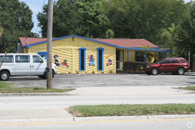
Property Record
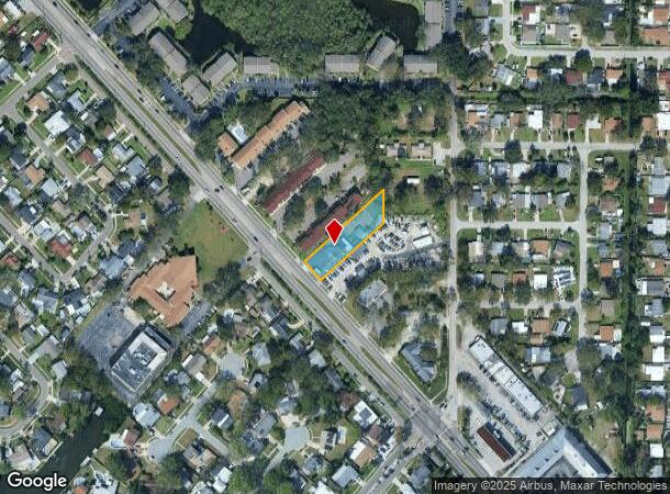
6033 Memorial Hwy, Tampa, FL 33615
NEARBY LISTINGS FOR SALE OR LEASE
Property Detail
6033 Memorial Hwy
Tampa-St. Petersburg-Clearwater, FL
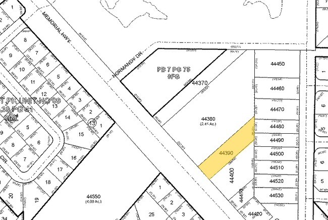
Unplatted
U-02-29-17-ZZZ-000000-44390.0
TRACT BEG 269 FT W & 283.46 FT S OF NE COR OF NW 1/4 OF SE 1/4 S 95.94 FT S 47 DEG 7 MIN 30 SEC W 263.63 FT TO HWY N 42 DEG 52 MIN 30 SEC W 70 FT N 47 DEG 7 MIN 30 SEC E 329.17 FT TO BEG LESS R/W
Daycare
Hillsborough
AE
Florida
12057C0327J
44390
2024
0.53 AC
2024
Westshore
011712
Tampa/St Petersburg
3,152 SF
DEMOGRAPHICS near 6033 Memorial Hwy
1 Mile
3 Mile
5 Mile
2024 Total Population
14,224
68,489
166,673
2029 Population
15,507
74,349
180,954
Pop Growth 2024-2029
+ 9.02%
+ 8.56%
+ 8.57%
Average Age
39
40
40
2024 Total Households
6,013
27,246
67,238
HH Growth 2024-2029
+ 9.31%
+ 8.86%
+ 8.91%
Median Household Inc
$58,592
$59,711
$62,498
Avg Household Size
2.30
2.40
2.40
2024 Avg HH Vehicles
2.00
2.00
2.00
Median Home Value
$354,092
$271,651
$286,675
Median Year Built
1980
1982
1986
Nearby Places
Map Layers
Map Styles
 Street
 Aerial
- Restaurants
- Banks
- Shops
- Fitness
- Groceries
PUBLIC TRANSPORTATION
AIRPORT
Tampa International
DRIVE
WALK
Distance
Tampa International
12 min
5.3 mi
St Pete-Clearwater International
DRIVE
WALK
Distance
St Pete-Clearwater International
32 min
16.8 mi
Freight Ports
Port of Tampa Bay
DRIVE
WALK
Distance
Port of Tampa Bay
25 min
13.7 mi
Nearby Properties
Address
Land Use
TOTAL SIZE
Lot Size
Zoning
Address
Land Use
TOTAL SIZE
Lot Size
Zoning
2,308,592 SF
1,915.65 AC
M-AP-1
Address
Land Use
TOTAL SIZE
Lot Size
Zoning
142,972 SF
21.79 AC
M-AP-1
Address
Land Use
TOTAL SIZE
Lot Size
Zoning
439,758 SF
22.14 AC
PD
Address
Land Use
TOTAL SIZE
Lot Size
Zoning
356,025 SF
4.57 AC
PD
Address
Land Use
TOTAL SIZE
Lot Size
Zoning
352,071 SF
21.42 AC
M-AP-2
Address
Land Use
TOTAL SIZE
Lot Size
Zoning
324,316 SF
84.32 AC
PD
Address
Land Use
TOTAL SIZE
Lot Size
Zoning
382,217 SF
29.74 AC
PD
Address
Land Use
TOTAL SIZE
Lot Size
Zoning
2,226 SF
438.48 AC
SPI-AP-1
Address
Land Use
TOTAL SIZE
Lot Size
Zoning
400,781 SF
43.59 AC
PD
Address
Land Use
TOTAL SIZE
Lot Size
Zoning
369,417 SF
13.42 AC
PD
Address
Land Use
TOTAL SIZE
Lot Size
Zoning
373,594 SF
19.75 AC
PD
Address
Land Use
TOTAL SIZE
Lot Size
Zoning
521,097 SF
30.92 AC
RMC-20
Address
Land Use
TOTAL SIZE
Lot Size
Zoning
365,470 SF
13.29 AC
M-AP-1
Address
Land Use
TOTAL SIZE
Lot Size
Zoning
346,527 SF
18.54 AC
PD
Address
Land Use
TOTAL SIZE
Lot Size
Zoning
245,701 SF
3.15 AC
PD
Address
Land Use
TOTAL SIZE
Lot Size
Zoning
438,367 SF
24.83 AC
PD
Address
Land Use
TOTAL SIZE
Lot Size
Zoning
280,274 SF
5.32 AC
PD
Address
Land Use
TOTAL SIZE
Lot Size
Zoning
356,818 SF
27.12 AC
RMC-16
Address
Land Use
TOTAL SIZE
Lot Size
Zoning
254,169 SF
3.12 AC
PD
Address
Land Use
TOTAL SIZE
Lot Size
Zoning
265,351 SF
14.68 AC
PD
Address
Land Use
TOTAL SIZE
Lot Size
Zoning
247,794 SF
11.19 AC
PD
Address
Land Use
TOTAL SIZE
Lot Size
Zoning
145,665 SF
3.99 AC
PD
Address
Land Use
TOTAL SIZE
Lot Size
Zoning
384,891 SF
18.49 AC
PD
Address
Land Use
TOTAL SIZE
Lot Size
Zoning
210,966 SF
6.49 AC
PD
Address
Land Use
TOTAL SIZE
Lot Size
Zoning
335,251 SF
20.34 AC
PD
Address
Land Use
TOTAL SIZE
Lot Size
Zoning
251,753 SF
15.96 AC
RMC-20
Address
Land Use
TOTAL SIZE
Lot Size
Zoning
279,943 SF
2.76 AC
PD
Address
Land Use
TOTAL SIZE
Lot Size
Zoning
294,690 SF
25.28 AC
PD
Address
Land Use
TOTAL SIZE
Lot Size
Zoning
357,507 SF
4.51 AC
M-AP-1
Address
Land Use
TOTAL SIZE
Lot Size
Zoning
257,358 SF
19.09 AC
SPI-AP-5
The World's #1 Commercial Real Estate Marketplace
Connect with us
© 2025 CoStar Group
The information above has been obtained from sources believed reliable. While we do not doubt its accuracy we have not verified it and make no guarantee, warranty or representation about it. It is your responsibility to independently confirm its accuracy and completeness. Any projections, opinions, assumptions, or estimates used are for example only and do not represent the current or future performance of the property. The value of this transaction to you depends on tax and other factors which should be evaluated by your tax, financial, and legal advisors. You and your advisors should conduct a careful, independent investigation of the property to determine to your satisfaction the suitability of the property for your needs.