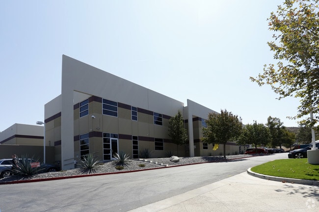
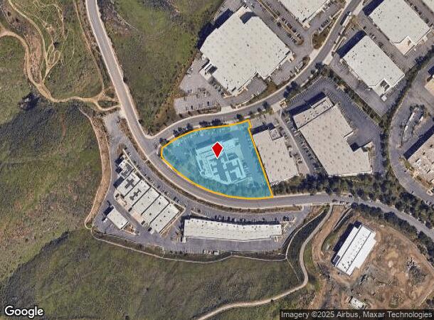
Property Record
2630 Conejo Spectrum St, Newbury Park, CA 91320

NEARBY LISTINGS FOR SALE OR LEASE
Property Detail
2630 Conejo Spectrum St
667-0-350-185
LOT: 11A REF: 141MR 81
Lightindustrial
Ventura
X
California
06111C0958E
11a
2024
2.67 AC
2025
Thousand Oaks
006102
Los Angeles
51,859 SF
Oxnard-Thousand Oaks-Ventura, CA
DEMOGRAPHICS near 2630 Conejo Spectrum St
1 Mile
3 Mile
5 Mile
2024 Total Population
3,285
48,878
120,098
2029 Population
3,261
48,040
118,262
Pop Growth 2024-2029
(0.73%)
(1.71%)
(1.53%)
Average Age
41
43
44
2024 Total Households
1,149
17,492
43,374
HH Growth 2024-2029
(0.87%)
(1.85%)
(1.61%)
Median Household Inc
$120,499
$118,807
$117,497
Avg Household Size
2.80
2.70
2.70
2024 Avg HH Vehicles
2.00
2.00
2.00
Median Home Value
$797,983
$786,101
$788,883
Median Year Built
1995
1976
1977
Nearby Places
Map Layers
Map Styles
 Street
 Aerial
- Restaurants
- Banks
- Shops
- Fitness
- Groceries
PUBLIC TRANSPORTATION
COMMUTER RAIL
Camarillo (Ventura County Line - Southern California Regional Rail Authority (Metrolink))
DRIVE
WALK
Distance
Camarillo (Ventura County Line - Southern California Regional Rail Authority (Metrolink))
14 min
7.9 mi
AIRPORT
Bob Hope
DRIVE
WALK
Distance
Bob Hope
56 min
39.7 mi
Los Angeles International
DRIVE
WALK
Distance
Los Angeles International
64 min
47.4 mi
Freight Ports
The Port of Hueneme
DRIVE
WALK
Distance
The Port of Hueneme
33 min
19.8 mi
Nearby Properties
Address
Land Use
TOTAL SIZE
Lot Size
Zoning
Address
Land Use
TOTAL SIZE
Lot Size
Zoning
2.08 AC
Address
Land Use
TOTAL SIZE
Lot Size
Zoning
13.12 AC
PL
Address
Land Use
TOTAL SIZE
Lot Size
Zoning
Address
Land Use
TOTAL SIZE
Lot Size
Zoning
Address
Land Use
TOTAL SIZE
Lot Size
Zoning
3.87 AC
Address
Land Use
TOTAL SIZE
Lot Size
Zoning
5.25 AC
Address
Land Use
TOTAL SIZE
Lot Size
Zoning
Address
Land Use
TOTAL SIZE
Lot Size
Zoning
Address
Land Use
TOTAL SIZE
Lot Size
Zoning
199,586 SF
8.95 AC
RPD25
Address
Land Use
TOTAL SIZE
Lot Size
Zoning
98,667 SF
17.87 AC
Address
Land Use
TOTAL SIZE
Lot Size
Zoning
Address
Land Use
TOTAL SIZE
Lot Size
Zoning
49,559 SF
2.87 AC
M1
Address
Land Use
TOTAL SIZE
Lot Size
Zoning
1.94 AC
Address
Land Use
TOTAL SIZE
Lot Size
Zoning
2.07 AC
Address
Land Use
TOTAL SIZE
Lot Size
Zoning
164,951 SF
10.20 AC
RPD.
Address
Land Use
TOTAL SIZE
Lot Size
Zoning
3.15 AC
Address
Land Use
TOTAL SIZE
Lot Size
Zoning
74,757 SF
9.01 AC
Address
Land Use
TOTAL SIZE
Lot Size
Zoning
Address
Land Use
TOTAL SIZE
Lot Size
Zoning
Address
Land Use
TOTAL SIZE
Lot Size
Zoning
68,015 SF
1.22 AC
Address
Land Use
TOTAL SIZE
Lot Size
Zoning
Address
Land Use
TOTAL SIZE
Lot Size
Zoning
73,565 SF
5.27 AC
MULT
Address
Land Use
TOTAL SIZE
Lot Size
Zoning
Address
Land Use
TOTAL SIZE
Lot Size
Zoning
21,878 SF
8.22 AC
C4
Address
Land Use
TOTAL SIZE
Lot Size
Zoning
1.50 AC
Address
Land Use
TOTAL SIZE
Lot Size
Zoning
200,980 SF
12.20 AC
Address
Land Use
TOTAL SIZE
Lot Size
Zoning
12,244 SF
77.34 AC
M1
Address
Land Use
TOTAL SIZE
Lot Size
Zoning
129,823 SF
8.30 AC
Address
Land Use
TOTAL SIZE
Lot Size
Zoning
11.60 AC
Address
Land Use
TOTAL SIZE
Lot Size
Zoning
241,406 SF
14.10 AC
RPD.
The World's #1 Commercial Real Estate Marketplace
Connect with us
© 2025 CoStar Group
The information above has been obtained from sources believed reliable. While we do not doubt its accuracy we have not verified it and make no guarantee, warranty or representation about it. It is your responsibility to independently confirm its accuracy and completeness. Any projections, opinions, assumptions, or estimates used are for example only and do not represent the current or future performance of the property. The value of this transaction to you depends on tax and other factors which should be evaluated by your tax, financial, and legal advisors. You and your advisors should conduct a careful, independent investigation of the property to determine to your satisfaction the suitability of the property for your needs.