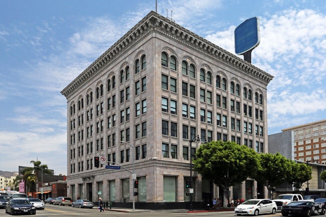
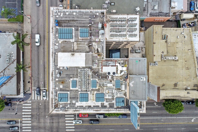
Property Record
6381 Hollywood Blvd, Los Angeles, CA 90028

Current Lease Availabilities
Property Detail
6381 Hollywood Blvd
5546-005-029
HOLLYWOOD SEE ASSESSORS MAPS POR LOTS 9,10,11,12, 14 AND 15 BLK 20
Officebuilding
LOS ANGELES
LAC4
California
B and X Area of moderate flood hazard, usually the area between the limits of the 100-year and 500-year floods.
9
2024
0.70 AC
2025
Hollywood
190201
Los Angeles
72,167 SF
Los Angeles-Long Beach-Glendale, CA
NEARBY LISTINGS FOR SALE OR LEASE
DEMOGRAPHICS near 6381 Hollywood Blvd
1 mile
3 mile
5 mile
2025 Total Population
58,870
342,383
931,826
2030 Population
60,229
343,350
931,552
Pop Growth 2025-2030
+ 2.31%
+ 0.28%
(0.03%)
Average Age
40
41
40
2025 Total Households
32,100
167,529
412,867
HH Growth 2025-2030
+ 2.22%
+ 0.10%
(0.18%)
Median Household Inc
$66,856
$77,485
$76,232
Avg Household Size
1.70
2.00
2.20
2025 Avg HH Vehicles
1.00
1.00
1.00
Median Home Value
$1,083,855
$1,093,819
$1,084,469
Median Year Built
1969
1962
1961
Nearby Places
Map Layers
Map Styles
 Street
 Aerial
Transit
 Traffic
 Biking
Places
Listings with unknown addresses are not visible on the map
- Restaurants
- Banks
- Shops
- Fitness
- Groceries
PUBLIC TRANSPORTATION
TRANSIT/SUBWAY
Hollywood/Vine Station (Red Line - Los Angeles County Metropolitan Transportation Authority (Metro))
Drive
Walk
Distance
Hollywood/Vine Station (Red Line - Los Angeles County Metropolitan Transportation Authority (Metro))
1 min
4 min
0.2 mi
Hollywood/Highland Station (Red Line - Los Angeles County Metropolitan Transportation Authority (Metro))
Drive
Walk
Distance
Hollywood/Highland Station (Red Line - Los Angeles County Metropolitan Transportation Authority (Metro))
2 min
11 min
0.6 mi
COMMUTER RAIL
Glendale (Antelope Valley Line - Southern California Regional Rail Authority (Metrolink), Ventura County Line - Southern California Regional Rail Authority (Metrolink))
Drive
Walk
Distance
Glendale (Antelope Valley Line - Southern California Regional Rail Authority (Metrolink), Ventura County Line - Southern California Regional Rail Authority (Metrolink))
12 min
5.4 mi
Downtown Burbank (Antelope Valley Line - Southern California Regional Rail Authority (Metrolink), Ventura County Line - Southern California Regional Rail Authority (Metrolink))
Drive
Walk
Distance
Downtown Burbank (Antelope Valley Line - Southern California Regional Rail Authority (Metrolink), Ventura County Line - Southern California Regional Rail Authority (Metrolink))
14 min
6.4 mi
AIRPORT
Bob Hope
Drive
Walk
Distance
Bob Hope
17 min
8.5 mi
Los Angeles International
Drive
Walk
Distance
Los Angeles International
31 min
14.2 mi
Long Beach (Daugherty Field)
Drive
Walk
Distance
Long Beach (Daugherty Field)
41 min
29.4 mi
Freight Ports
Port of Long Beach
Drive
Walk
Distance
Port of Long Beach
44 min
31.0 mi
Nearby Properties
Address
Land Use
TOTAL SIZE
Lot Size
Zoning
Address
Land Use
TOTAL SIZE
Lot Size
Zoning
930,249 SF
7.39 AC
LAC2
Address
Land Use
TOTAL SIZE
Lot Size
Zoning
21,585 SF
61.40 AC
LAM11/2*
Address
Land Use
TOTAL SIZE
Lot Size
Zoning
1,314,760 SF
33.64 AC
LAM11/2*
Address
Land Use
TOTAL SIZE
Lot Size
Zoning
709,584 SF
1.80 AC
LAPB
Address
Land Use
TOTAL SIZE
Lot Size
Zoning
161,046 SF
6.88 AC
LAM1
Address
Land Use
TOTAL SIZE
Lot Size
Zoning
12,827 SF
130.37 AC
LAM11/2*
Address
Land Use
TOTAL SIZE
Lot Size
Zoning
67,126 SF
48.09 AC
LAM1
Address
Land Use
TOTAL SIZE
Lot Size
Zoning
472,363 SF
3.24 AC
LAC4
Address
Land Use
TOTAL SIZE
Lot Size
Zoning
515,531 SF
14.65 AC
LAC2
Address
Land Use
TOTAL SIZE
Lot Size
Zoning
497,377 SF
3.29 AC
LAC4
Address
Land Use
TOTAL SIZE
Lot Size
Zoning
986,983 SF
105.50 AC
LARE40
Address
Land Use
TOTAL SIZE
Lot Size
Zoning
793,274 SF
7.80 AC
LAR4
Address
Land Use
TOTAL SIZE
Lot Size
Zoning
125,170 SF
Address
Land Use
TOTAL SIZE
Lot Size
Zoning
724,958 SF
5.88 AC
LAC2
Address
Land Use
TOTAL SIZE
Lot Size
Zoning
289,633 SF
1.55 AC
LAP
Address
Land Use
TOTAL SIZE
Lot Size
Zoning
255,868 SF
9.58 AC
WDC2C*
Address
Land Use
TOTAL SIZE
Lot Size
Zoning
8.93 AC
LAC2
Address
Land Use
TOTAL SIZE
Lot Size
Zoning
679,557 SF
6.41 AC
LAC2
Address
Land Use
TOTAL SIZE
Lot Size
Zoning
556,235 SF
4.22 AC
LAC4
Address
Land Use
TOTAL SIZE
Lot Size
Zoning
406,948 SF
8.04 AC
LAC2
Address
Land Use
TOTAL SIZE
Lot Size
Zoning
490,689 SF
3.60 AC
LAM1
Address
Land Use
TOTAL SIZE
Lot Size
Zoning
256,032 SF
4.69 AC
LAC4
Address
Land Use
TOTAL SIZE
Lot Size
Zoning
366,349 SF
2.98 AC
WDC2C*
Address
Land Use
TOTAL SIZE
Lot Size
Zoning
320,944 SF
1.97 AC
LAC4
Address
Land Use
TOTAL SIZE
Lot Size
Zoning
264,720 SF
4.69 AC
LAC4
Address
Land Use
TOTAL SIZE
Lot Size
Zoning
347,880 SF
0.41 AC
LAC4
Address
Land Use
TOTAL SIZE
Lot Size
Zoning
481,534 SF
2.11 AC
WDC2
Address
Land Use
TOTAL SIZE
Lot Size
Zoning
184,029 SF
0.80 AC
WDC2A*
Address
Land Use
TOTAL SIZE
Lot Size
Zoning
292,714 SF
1.90 AC
LAR5
Address
Land Use
TOTAL SIZE
Lot Size
Zoning
347,123 SF
1.66 AC
The World's #1 Commercial Real Estate Marketplace
Connect with us
© 2026 CoStar Group
The information above has been obtained from sources believed reliable. While we do not doubt its accuracy we have not verified it and make no guarantee, warranty or representation about it. It is your responsibility to independently confirm its accuracy and completeness. Any projections, opinions, assumptions, or estimates used are for example only and do not represent the current or future performance of the property. The value of this transaction to you depends on tax and other factors which should be evaluated by your tax, financial, and legal advisors. You and your advisors should conduct a careful, independent investigation of the property to determine to your satisfaction the suitability of the property for your needs.