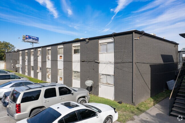
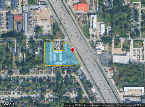
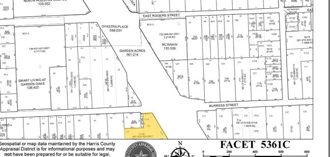
Property Record
5135 North Fwy, Houston, TX 77022
NEARBY LISTINGS FOR SALE OR LEASE
Property Detail
5135 North Fwy
Houston-The Woodlands-Sugar Land, TX
Garden Acres
0970590000001
LT 71 & TRS 123 124 & 125 & LT 70 GARDEN ACRES NORTHLINE MANOR APTS
Commercialnec
Harris
AE
Texas
48201C0660M
71,70
2024
2.30 AC
2025
Independence Heights
530501
Houston
64,912 SF
DEMOGRAPHICS near 5135 North Fwy
1 Mile
3 Mile
5 Mile
2024 Total Population
16,340
139,314
365,542
2029 Population
16,782
143,371
376,710
Pop Growth 2024-2029
+ 2.71%
+ 2.91%
+ 3.06%
Average Age
38
37
36
2024 Total Households
5,869
49,778
135,904
HH Growth 2024-2029
+ 2.68%
+ 3.10%
+ 3.32%
Median Household Inc
$31,695
$52,166
$57,332
Avg Household Size
2.70
2.70
2.60
2024 Avg HH Vehicles
2.00
2.00
2.00
Median Home Value
$168,166
$289,022
$292,849
Median Year Built
1966
1967
1973
Nearby Places
Map Layers
Map Styles
 Street
 Aerial
- Restaurants
- Banks
- Shops
- Fitness
- Groceries
PUBLIC TRANSPORTATION
COMMUTER RAIL
Houston (Sunset Limited - Amtrak)
DRIVE
WALK
Distance
Houston (Sunset Limited - Amtrak)
9 min
5.7 mi
AIRPORT
George Bush Intcntl/Houston
DRIVE
WALK
Distance
George Bush Intcntl/Houston
22 min
17.0 mi
William P Hobby
DRIVE
WALK
Distance
William P Hobby
30 min
18.5 mi
Freight Ports
Port of Houston
DRIVE
WALK
Distance
Port of Houston
22 min
14.1 mi
Nearby Properties
Address
Land Use
TOTAL SIZE
Lot Size
Zoning
Address
Land Use
TOTAL SIZE
Lot Size
Zoning
453,456 SF
3.11 AC
Address
Land Use
TOTAL SIZE
Lot Size
Zoning
519,374 SF
6.18 AC
Address
Land Use
TOTAL SIZE
Lot Size
Zoning
563,626 SF
4.71 AC
Address
Land Use
TOTAL SIZE
Lot Size
Zoning
474,326 SF
43.16 AC
Address
Land Use
TOTAL SIZE
Lot Size
Zoning
432,691 SF
3.26 AC
Address
Land Use
TOTAL SIZE
Lot Size
Zoning
261,312 SF
1.81 AC
Address
Land Use
TOTAL SIZE
Lot Size
Zoning
593,265 SF
3.73 AC
Address
Land Use
TOTAL SIZE
Lot Size
Zoning
594,105 SF
43.68 AC
Address
Land Use
TOTAL SIZE
Lot Size
Zoning
379,725 SF
2.84 AC
Address
Land Use
TOTAL SIZE
Lot Size
Zoning
587,156 SF
4.40 AC
Address
Land Use
TOTAL SIZE
Lot Size
Zoning
440,577 SF
4.13 AC
Address
Land Use
TOTAL SIZE
Lot Size
Zoning
87,179 SF
4.13 AC
Address
Land Use
TOTAL SIZE
Lot Size
Zoning
322,880 SF
2.61 AC
Address
Land Use
TOTAL SIZE
Lot Size
Zoning
402,433 SF
2.77 AC
Address
Land Use
TOTAL SIZE
Lot Size
Zoning
263,475 SF
7.90 AC
Address
Land Use
TOTAL SIZE
Lot Size
Zoning
279,452 SF
5.69 AC
Address
Land Use
TOTAL SIZE
Lot Size
Zoning
198,770 SF
2.10 AC
Address
Land Use
TOTAL SIZE
Lot Size
Zoning
235,535 SF
1.71 AC
Address
Land Use
TOTAL SIZE
Lot Size
Zoning
276,332 SF
6.05 AC
Address
Land Use
TOTAL SIZE
Lot Size
Zoning
545,628 SF
19.41 AC
Address
Land Use
TOTAL SIZE
Lot Size
Zoning
531,786 SF
17.60 AC
Address
Land Use
TOTAL SIZE
Lot Size
Zoning
197,696 SF
3.06 AC
Address
Land Use
TOTAL SIZE
Lot Size
Zoning
194,990 SF
16.36 AC
Address
Land Use
TOTAL SIZE
Lot Size
Zoning
213,548 SF
16.98 AC
Address
Land Use
TOTAL SIZE
Lot Size
Zoning
160,849 SF
2.14 AC
Address
Land Use
TOTAL SIZE
Lot Size
Zoning
105,268 SF
7.26 AC
Address
Land Use
TOTAL SIZE
Lot Size
Zoning
211,564 SF
1.20 AC
Address
Land Use
TOTAL SIZE
Lot Size
Zoning
200,511 SF
9.48 AC
Address
Land Use
TOTAL SIZE
Lot Size
Zoning
188,582 SF
17.94 AC
Address
Land Use
TOTAL SIZE
Lot Size
Zoning
64,521 SF
3.91 AC
The World's #1 Commercial Real Estate Marketplace
Connect with us
© 2025 CoStar Group
The information above has been obtained from sources believed reliable. While we do not doubt its accuracy we have not verified it and make no guarantee, warranty or representation about it. It is your responsibility to independently confirm its accuracy and completeness. Any projections, opinions, assumptions, or estimates used are for example only and do not represent the current or future performance of the property. The value of this transaction to you depends on tax and other factors which should be evaluated by your tax, financial, and legal advisors. You and your advisors should conduct a careful, independent investigation of the property to determine to your satisfaction the suitability of the property for your needs.