Property Record
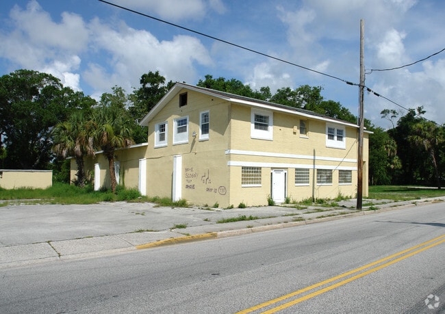
844 S Dr Martin Luther King Jr Blvd, Daytona Beach, FL 32114


Property Detail
844 S Dr Martin Luther King Jr Blvd
Deltona-Daytona Beach-Ormond Beach, FL
39-15-33 LOTS 3 TO 6 INC BLK E HARRIET L HIGBEES RESUB MB 2 PG 199 MB 22 PG 17 OF HIGBEES ADD TO DAYTONA DB L PG 704 MB 12 PG 98 PER OR 4461 PG 4280 PER OR 6279 PG 2786 PER OR 6431 PG 0475
5339-90-05-0030
VOLUSIA
Officebuilding
Florida
AE The base floodplain where base flood elevations are provided. AE Zones are now used on new format FIRMs instead of A1-A30 Zones.
3-6
0
0.62 AC
2026
Downtown Daytona Beach
082100
Deltona/Daytona Beach
6,191 SF
NEARBY LISTINGS FOR SALE OR LEASE
DEMOGRAPHICS near 844 S Dr Martin Luther King Jr Blvd
1 mile
3 mile
5 mile
2025 Total Population
12,178
74,115
141,870
2030 Population
13,130
80,000
153,394
Pop Growth 2025-2030
+ 7.82%
+ 7.94%
+ 8.12%
Average Age
40
43
44
2025 Total Households
5,251
32,357
63,904
HH Growth 2025-2030
+ 7.58%
+ 8.10%
+ 8.31%
Median Household Inc
$38,566
$48,580
$53,566
Avg Household Size
2.10
2.00
2.00
2025 Avg HH Vehicles
1.00
1.00
1.00
Median Home Value
$223,883
$249,255
$267,772
Median Year Built
1975
1976
1979
Nearby Places
Map Layers
Map Styles
 Street
 Aerial
Layers
 Traffic
 Biking
Places
Listings with unknown addresses are not visible on the map
- Restaurants
- Banks
- Shops
- Fitness
- Groceries
PUBLIC TRANSPORTATION
AIRPORT
Daytona Beach International
Drive
Walk
Distance
Daytona Beach International
9 min
3.7 mi
Orlando Sanford International
Drive
Walk
Distance
Orlando Sanford International
57 min
42.4 mi
Nearby Properties
Address
Land Use
TOTAL SIZE
Lot Size
Zoning
Address
Land Use
TOTAL SIZE
Lot Size
Zoning
2,673,647 SF
110.95 AC
I12
Address
Land Use
TOTAL SIZE
Lot Size
Zoning
1,365,998 SF
13 AC
Address
Land Use
TOTAL SIZE
Lot Size
Zoning
1,842,969 SF
25.56 AC
Address
Land Use
TOTAL SIZE
Lot Size
Zoning
664,082 SF
38.16 AC
02BA
Address
Land Use
TOTAL SIZE
Lot Size
Zoning
1,058,116 SF
54.22 AC
Address
Land Use
TOTAL SIZE
Lot Size
Zoning
880,289 SF
4.98 AC
02T3
Address
Land Use
TOTAL SIZE
Lot Size
Zoning
Address
Land Use
TOTAL SIZE
Lot Size
Zoning
542,849 SF
1.56 AC
02T1
Address
Land Use
TOTAL SIZE
Lot Size
Zoning
472,750 SF
16.76 AC
Address
Land Use
TOTAL SIZE
Lot Size
Zoning
223,127 SF
14.47 AC
Address
Land Use
TOTAL SIZE
Lot Size
Zoning
353,548 SF
50.65 AC
Address
Land Use
TOTAL SIZE
Lot Size
Zoning
13,965 SF
0.70 AC
MH1
Address
Land Use
TOTAL SIZE
Lot Size
Zoning
275,814 SF
13 AC
Address
Land Use
TOTAL SIZE
Lot Size
Zoning
Address
Land Use
TOTAL SIZE
Lot Size
Zoning
286,461 SF
945.48 AC
B62
Address
Land Use
TOTAL SIZE
Lot Size
Zoning
197,581 SF
14.58 AC
Address
Land Use
TOTAL SIZE
Lot Size
Zoning
291,590 SF
11.68 AC
Address
Land Use
TOTAL SIZE
Lot Size
Zoning
300,038 SF
0.22 AC
Address
Land Use
TOTAL SIZE
Lot Size
Zoning
226,459 SF
0.57 AC
Address
Land Use
TOTAL SIZE
Lot Size
Zoning
303,151 SF
13.58 AC
Address
Land Use
TOTAL SIZE
Lot Size
Zoning
330,883 SF
19.59 AC
Address
Land Use
TOTAL SIZE
Lot Size
Zoning
269,133 SF
6.33 AC
Address
Land Use
TOTAL SIZE
Lot Size
Zoning
379,591 SF
21.62 AC
MH1
Address
Land Use
TOTAL SIZE
Lot Size
Zoning
306,467 SF
20.76 AC
Address
Land Use
TOTAL SIZE
Lot Size
Zoning
5,774 SF
0.94 AC
B4
Address
Land Use
TOTAL SIZE
Lot Size
Zoning
560,165 SF
37.79 AC
02BR2
Address
Land Use
TOTAL SIZE
Lot Size
Zoning
318,230 SF
21.28 AC
Address
Land Use
TOTAL SIZE
Lot Size
Zoning
12,871 SF
0.20 AC
R4
Address
Land Use
TOTAL SIZE
Lot Size
Zoning
153,293 SF
10.95 AC
Address
Land Use
TOTAL SIZE
Lot Size
Zoning
105,866 SF
5.14 AC
The World's #1 Commercial Real Estate Marketplace
Connect with us
© 2026 CoStar Group
The information above has been obtained from sources believed reliable. While we do not doubt its accuracy we have not verified it and make no guarantee, warranty or representation about it. It is your responsibility to independently confirm its accuracy and completeness. Any projections, opinions, assumptions, or estimates used are for example only and do not represent the current or future performance of the property. The value of this transaction to you depends on tax and other factors which should be evaluated by your tax, financial, and legal advisors. You and your advisors should conduct a careful, independent investigation of the property to determine to your satisfaction the suitability of the property for your needs.