Property Record
333 N Mineral Springs Rd, Chesterton, IN 46304
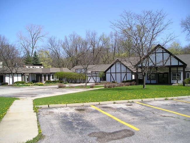
Property Detail
333 N Mineral Springs Rd
64-03-35-102-001.000-026
PAR IN NW 35-37-6 DESC DR399 P328 .26A ABATEMENT
Restaurantbuilding
PORTER
AE The base floodplain where base flood elevations are provided. AE Zones are now used on new format FIRMs instead of A1-A30 Zones.
Indiana
2024
3.01 AC
2025
Porter County
050302
Chicago
8,054 SF
Chicago-Naperville-Elgin, IL-IN
NEARBY LISTINGS FOR SALE OR LEASE
-
-
View all Chesterton listings for sale on LoopNet.com
DEMOGRAPHICS near 333 N Mineral Springs Rd
1 mile
3 mile
5 mile
2024 Total Population
3,257
20,629
39,632
2029 Population
3,287
20,875
40,212
Pop Growth 2024-2029
+ 0.92%
+ 1.19%
+ 1.46%
Average Age
40
41
42
2024 Total Households
1,306
8,233
15,235
HH Growth 2024-2029
+ 0.77%
+ 1.07%
+ 1.36%
Median Household Inc
$68,529
$74,942
$79,732
Avg Household Size
2.50
2.50
2.50
2024 Avg HH Vehicles
2.00
2.00
2.00
Median Home Value
$244,306
$278,296
$291,597
Median Year Built
1974
1979
1987
Nearby Places
Map Layers
Map Styles
 Street
 Aerial
Transit
 Traffic
 Biking
Places
Listings with unknown addresses are not visible on the map
- Restaurants
- Banks
- Shops
- Fitness
- Groceries
PUBLIC TRANSPORTATION
COMMUTER RAIL
Dune Park (Chesterton) Station (South Shore Line - Northern Indiana Commuter Transportation District (South Shore Line))
Drive
Walk
Distance
Dune Park (Chesterton) Station (South Shore Line - Northern Indiana Commuter Transportation District (South Shore Line))
5 min
2.7 mi
Ogden Dunes (Portage) Station (South Shore Line - Northern Indiana Commuter Transportation District (South Shore Line))
Drive
Walk
Distance
Ogden Dunes (Portage) Station (South Shore Line - Northern Indiana Commuter Transportation District (South Shore Line))
11 min
6.8 mi
Freight Ports
Port Milwaukee
Drive
Walk
Distance
Port Milwaukee
163 min
130.0 mi
SALE & LEASE HISTORY
LISTING DATE
SALE/LEASE

Feb 16, 2019
For Sale
Nearby Properties
Address
Land Use
TOTAL SIZE
Lot Size
Zoning
Address
Land Use
TOTAL SIZE
Lot Size
Zoning
5,092,064 SF
629.78 AC
Address
Land Use
TOTAL SIZE
Lot Size
Zoning
3,431,129 SF
424.65 AC
Address
Land Use
TOTAL SIZE
Lot Size
Zoning
174,766 SF
17.47 AC
Address
Land Use
TOTAL SIZE
Lot Size
Zoning
789,622 SF
200.71 AC
Address
Land Use
TOTAL SIZE
Lot Size
Zoning
108,528 SF
10.28 AC
Address
Land Use
TOTAL SIZE
Lot Size
Zoning
164,280 SF
46.39 AC
Address
Land Use
TOTAL SIZE
Lot Size
Zoning
233,491 SF
37.81 AC
Address
Land Use
TOTAL SIZE
Lot Size
Zoning
27,375 SF
35.78 AC
Address
Land Use
TOTAL SIZE
Lot Size
Zoning
34,360 SF
30.57 AC
Address
Land Use
TOTAL SIZE
Lot Size
Zoning
52,765 SF
5.92 AC
Address
Land Use
TOTAL SIZE
Lot Size
Zoning
61,873 SF
8 AC
Address
Land Use
TOTAL SIZE
Lot Size
Zoning
478,084 SF
45.58 AC
Address
Land Use
TOTAL SIZE
Lot Size
Zoning
114,061 SF
6.26 AC
Address
Land Use
TOTAL SIZE
Lot Size
Zoning
73,376 SF
5.18 AC
Address
Land Use
TOTAL SIZE
Lot Size
Zoning
164,640 SF
9.38 AC
Address
Land Use
TOTAL SIZE
Lot Size
Zoning
38,337 SF
10 AC
Address
Land Use
TOTAL SIZE
Lot Size
Zoning
62,401 SF
9.83 AC
Address
Land Use
TOTAL SIZE
Lot Size
Zoning
91,750 SF
9.45 AC
Address
Land Use
TOTAL SIZE
Lot Size
Zoning
61,561 SF
3.71 AC
Address
Land Use
TOTAL SIZE
Lot Size
Zoning
90,396 SF
6.82 AC
Address
Land Use
TOTAL SIZE
Lot Size
Zoning
13,013 SF
17.26 AC
Address
Land Use
TOTAL SIZE
Lot Size
Zoning
62,261 SF
5.69 AC
Address
Land Use
TOTAL SIZE
Lot Size
Zoning
419,212 SF
76.91 AC
Address
Land Use
TOTAL SIZE
Lot Size
Zoning
26,090 SF
5.68 AC
Address
Land Use
TOTAL SIZE
Lot Size
Zoning
60,861 SF
5.94 AC
Address
Land Use
TOTAL SIZE
Lot Size
Zoning
20,400 SF
7.39 AC
Address
Land Use
TOTAL SIZE
Lot Size
Zoning
70,760 SF
7.68 AC
Address
Land Use
TOTAL SIZE
Lot Size
Zoning
63,357 SF
7.10 AC
Address
Land Use
TOTAL SIZE
Lot Size
Zoning
233,538 SF
6.81 AC
Address
Land Use
TOTAL SIZE
Lot Size
Zoning
72,400 SF
2.82 AC
The World's #1 Commercial Real Estate Marketplace
Connect with us
© 2026 CoStar Group
The information above has been obtained from sources believed reliable. While we do not doubt its accuracy we have not verified it and make no guarantee, warranty or representation about it. It is your responsibility to independently confirm its accuracy and completeness. Any projections, opinions, assumptions, or estimates used are for example only and do not represent the current or future performance of the property. The value of this transaction to you depends on tax and other factors which should be evaluated by your tax, financial, and legal advisors. You and your advisors should conduct a careful, independent investigation of the property to determine to your satisfaction the suitability of the property for your needs.