Property Record
281 Sumneytown Pike, Harleysville, PA 19438
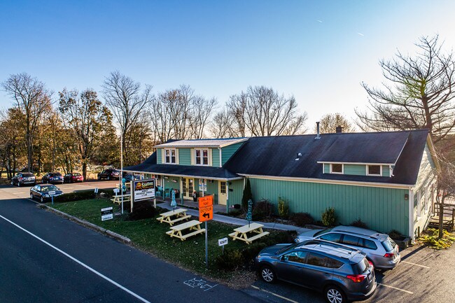

Property Detail
281 Sumneytown Pike
62-00-02209-006
ASSESSOR BLOCK-UNIT NUMBER 10-14
Storebuilding
MONTGOMERY
CB
Pennsylvania
B and X Area of moderate flood hazard, usually the area between the limits of the 100-year and 500-year floods.
14
2024
1.45 AC
2025
West Montgomery County
207500
Philadelphia
7,350 SF
Philadelphia-Camden-Wilmington, PA-NJ-DE-MD
NEARBY LISTINGS FOR SALE OR LEASE
DEMOGRAPHICS near 281 Sumneytown Pike
1 mile
3 mile
5 mile
2024 Total Population
1,441
20,421
63,680
2029 Population
1,504
20,712
64,316
Pop Growth 2024-2029
+ 4.37%
+ 1.43%
+ 1.00%
Average Age
46
43
43
2024 Total Households
462
7,392
23,674
HH Growth 2024-2029
+ 4.55%
+ 1.39%
+ 1.00%
Median Household Inc
$154,060
$122,369
$107,501
Avg Household Size
2.80
2.60
2.60
2024 Avg HH Vehicles
2.00
2.00
2.00
Median Home Value
$543,689
$421,502
$374,944
Median Year Built
1988
1984
1983
Nearby Places
Map Layers
Map Styles
 Street
 Aerial
Transit
 Traffic
 Biking
Places
Listings with unknown addresses are not visible on the map
- Restaurants
- Banks
- Shops
- Fitness
- Groceries
PUBLIC TRANSPORTATION
COMMUTER RAIL
Lansdale (R5 - Southeastern Pennsylvania Transportation Authority Regional Rail (SEPTA Regional Rail))
Drive
Walk
Distance
Lansdale (R5 - Southeastern Pennsylvania Transportation Authority Regional Rail (SEPTA Regional Rail))
19 min
9.3 mi
AIRPORT
Lehigh Valley International
Drive
Walk
Distance
Lehigh Valley International
53 min
36.8 mi
Philadelphia International
Drive
Walk
Distance
Philadelphia International
58 min
41.5 mi
Trenton Mercer
Drive
Walk
Distance
Trenton Mercer
65 min
49.9 mi
SALE & LEASE HISTORY
LISTING DATE
SALE/LEASE

Oct 19, 2020
For Sale
Nov 27, 2019
For Sale
Nearby Properties
Address
Land Use
TOTAL SIZE
Lot Size
Zoning
Address
Land Use
TOTAL SIZE
Lot Size
Zoning
437,908 SF
104.29 AC
INST
Address
Land Use
TOTAL SIZE
Lot Size
Zoning
677,546 SF
92.50 AC
INST
Address
Land Use
TOTAL SIZE
Lot Size
Zoning
149,259 SF
4.30 AC
R3
Address
Land Use
TOTAL SIZE
Lot Size
Zoning
156,694 SF
18.82 AC
C
Address
Land Use
TOTAL SIZE
Lot Size
Zoning
147,113 SF
31.41 AC
R1
Address
Land Use
TOTAL SIZE
Lot Size
Zoning
136,281 SF
4.05 AC
R3
Address
Land Use
TOTAL SIZE
Lot Size
Zoning
52,348 SF
21.30 AC
R5
Address
Land Use
TOTAL SIZE
Lot Size
Zoning
84,887 SF
38.07 AC
INST
Address
Land Use
TOTAL SIZE
Lot Size
Zoning
246,631 SF
48.78 AC
AO
Address
Land Use
TOTAL SIZE
Lot Size
Zoning
112,282 SF
11.23 AC
R5
Address
Land Use
TOTAL SIZE
Lot Size
Zoning
93,049 SF
20.88 AC
CB
Address
Land Use
TOTAL SIZE
Lot Size
Zoning
60,519 SF
20.68 AC
R1
Address
Land Use
TOTAL SIZE
Lot Size
Zoning
96,305 SF
3.02 AC
Address
Land Use
TOTAL SIZE
Lot Size
Zoning
95,494 SF
13.67 AC
C
Address
Land Use
TOTAL SIZE
Lot Size
Zoning
61,855 SF
13.26 AC
IN
Address
Land Use
TOTAL SIZE
Lot Size
Zoning
54,212 SF
18.38 AC
RR
Address
Land Use
TOTAL SIZE
Lot Size
Zoning
41,578 SF
16.89 AC
R3
Address
Land Use
TOTAL SIZE
Lot Size
Zoning
140,008 SF
10.25 AC
C
Address
Land Use
TOTAL SIZE
Lot Size
Zoning
122,551 SF
7.57 AC
LI
Address
Land Use
TOTAL SIZE
Lot Size
Zoning
22,944 SF
6.57 AC
R2
Address
Land Use
TOTAL SIZE
Lot Size
Zoning
39,066 SF
24.21 AC
REC
Address
Land Use
TOTAL SIZE
Lot Size
Zoning
62,666 SF
2.46 AC
R3
Address
Land Use
TOTAL SIZE
Lot Size
Zoning
23,022 SF
2.64 AC
MU
Address
Land Use
TOTAL SIZE
Lot Size
Zoning
37,060 SF
8.38 AC
C
Address
Land Use
TOTAL SIZE
Lot Size
Zoning
40,300 SF
1.05 AC
Address
Land Use
TOTAL SIZE
Lot Size
Zoning
57,397 SF
25.55 AC
R1A
Address
Land Use
TOTAL SIZE
Lot Size
Zoning
71,214 SF
11.30 AC
LI
Address
Land Use
TOTAL SIZE
Lot Size
Zoning
88,050 SF
8.68 AC
R4
Address
Land Use
TOTAL SIZE
Lot Size
Zoning
25,354 SF
13.62 AC
INST
Address
Land Use
TOTAL SIZE
Lot Size
Zoning
20,781 SF
4.80 AC
R2
The World's #1 Commercial Real Estate Marketplace
Connect with us
© 2026 CoStar Group
The information above has been obtained from sources believed reliable. While we do not doubt its accuracy we have not verified it and make no guarantee, warranty or representation about it. It is your responsibility to independently confirm its accuracy and completeness. Any projections, opinions, assumptions, or estimates used are for example only and do not represent the current or future performance of the property. The value of this transaction to you depends on tax and other factors which should be evaluated by your tax, financial, and legal advisors. You and your advisors should conduct a careful, independent investigation of the property to determine to your satisfaction the suitability of the property for your needs.