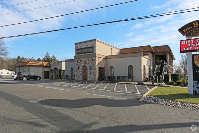
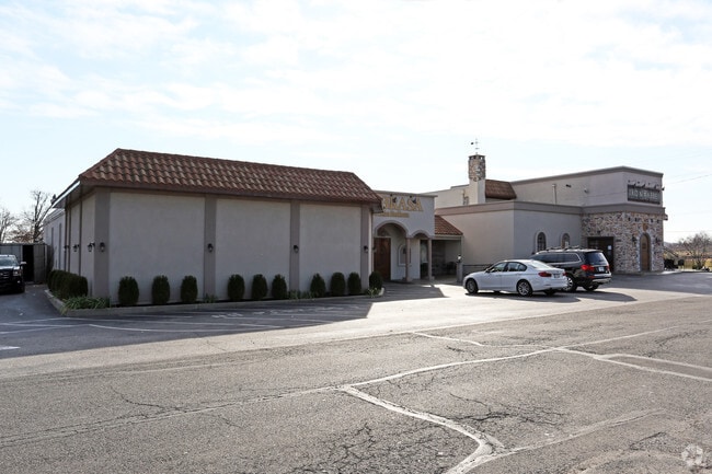
Property Record
680 Easton Rd, Horsham, PA 19044


Property Detail
680 Easton Rd
36-00-03850-002
U 20-21
Restaurantbuilding
MONTGOMERY
GC2
Pennsylvania
B and X Area of moderate flood hazard, usually the area between the limits of the 100-year and 500-year floods.
3
2024
1.64 AC
2025
Horsham/Willow Grove
200502
Philadelphia
30,984 SF
Philadelphia-Camden-Wilmington, PA-NJ-DE-MD
NEARBY LISTINGS FOR SALE OR LEASE
DEMOGRAPHICS near 680 Easton Rd
1 mile
3 mile
5 mile
2024 Total Population
10,571
83,123
199,244
2029 Population
10,766
85,099
203,096
Pop Growth 2024-2029
+ 1.84%
+ 2.38%
+ 1.93%
Average Age
41
42
43
2024 Total Households
4,279
33,153
76,587
HH Growth 2024-2029
+ 1.82%
+ 2.56%
+ 2.05%
Median Household Inc
$80,729
$103,763
$107,848
Avg Household Size
2.40
2.40
2.50
2024 Avg HH Vehicles
2.00
2.00
2.00
Median Home Value
$382,908
$417,380
$450,849
Median Year Built
1970
1969
1971
Nearby Places
Map Layers
Map Styles
 Street
 Aerial
Transit
 Traffic
 Biking
Places
Listings with unknown addresses are not visible on the map
- Restaurants
- Banks
- Shops
- Fitness
- Groceries
PUBLIC TRANSPORTATION
COMMUTER RAIL
Hatboro (R2 - Southeastern Pennsylvania Transportation Authority Regional Rail (SEPTA Regional Rail))
Drive
Walk
Distance
Hatboro (R2 - Southeastern Pennsylvania Transportation Authority Regional Rail (SEPTA Regional Rail))
7 min
2.6 mi
Willow Grove (R2 - Southeastern Pennsylvania Transportation Authority Regional Rail (SEPTA Regional Rail))
Drive
Walk
Distance
Willow Grove (R2 - Southeastern Pennsylvania Transportation Authority Regional Rail (SEPTA Regional Rail))
7 min
3.4 mi
AIRPORT
Trenton Mercer
Drive
Walk
Distance
Trenton Mercer
40 min
26.8 mi
Philadelphia International
Drive
Walk
Distance
Philadelphia International
54 min
37.7 mi
Lehigh Valley International
Drive
Walk
Distance
Lehigh Valley International
68 min
40.4 mi
Freight Ports
Port of Philadelphia
Drive
Walk
Distance
Port of Philadelphia
36 min
16.9 mi
SALE & LEASE HISTORY
LISTING DATE
SALE/LEASE

Jul 16, 2018
For Lease
Nearby Properties
Address
Land Use
TOTAL SIZE
Lot Size
Zoning
Address
Land Use
TOTAL SIZE
Lot Size
Zoning
1,006.32 AC
I1
Address
Land Use
TOTAL SIZE
Lot Size
Zoning
368,495 SF
68.37 AC
PI
Address
Land Use
TOTAL SIZE
Lot Size
Zoning
368,492 SF
58.98 AC
I1
Address
Land Use
TOTAL SIZE
Lot Size
Zoning
335,203 SF
31.20 AC
C1
Address
Land Use
TOTAL SIZE
Lot Size
Zoning
377,044 SF
58.73 AC
INST
Address
Land Use
TOTAL SIZE
Lot Size
Zoning
752,716 SF
0.29 AC
OC
Address
Land Use
TOTAL SIZE
Lot Size
Zoning
571,213 SF
67.31 AC
M
Address
Land Use
TOTAL SIZE
Lot Size
Zoning
272,344 SF
9.76 AC
I2
Address
Land Use
TOTAL SIZE
Lot Size
Zoning
343,852 SF
8.42 AC
I
Address
Land Use
TOTAL SIZE
Lot Size
Zoning
242,560 SF
1.40 AC
OC
Address
Land Use
TOTAL SIZE
Lot Size
Zoning
248,795 SF
16.64 AC
PI
Address
Land Use
TOTAL SIZE
Lot Size
Zoning
257,010 SF
34.12 AC
INST
Address
Land Use
TOTAL SIZE
Lot Size
Zoning
84,400 SF
4.70 AC
I
Address
Land Use
TOTAL SIZE
Lot Size
Zoning
388,525 SF
25.28 AC
OC
Address
Land Use
TOTAL SIZE
Lot Size
Zoning
309,264 SF
9.93 AC
I
Address
Land Use
TOTAL SIZE
Lot Size
Zoning
902,127 SF
89.67 AC
OC
Address
Land Use
TOTAL SIZE
Lot Size
Zoning
170,183 SF
46.63 AC
I1
Address
Land Use
TOTAL SIZE
Lot Size
Zoning
140,582 SF
52.93 AC
R2
Address
Land Use
TOTAL SIZE
Lot Size
Zoning
256,679 SF
14 AC
MI
Address
Land Use
TOTAL SIZE
Lot Size
Zoning
115,961 SF
12.70 AC
OC
Address
Land Use
TOTAL SIZE
Lot Size
Zoning
209,417 SF
20.72 AC
C1
Address
Land Use
TOTAL SIZE
Lot Size
Zoning
420,736 SF
29.47 AC
LI
Address
Land Use
TOTAL SIZE
Lot Size
Zoning
344,636 SF
25.02 AC
R7
Address
Land Use
TOTAL SIZE
Lot Size
Zoning
110,198 SF
12.18 AC
R2
Address
Land Use
TOTAL SIZE
Lot Size
Zoning
125,875 SF
16.09 AC
I2
Address
Land Use
TOTAL SIZE
Lot Size
Zoning
171,179 SF
6.12 AC
C2
Address
Land Use
TOTAL SIZE
Lot Size
Zoning
94,059 SF
19.22 AC
R4
Address
Land Use
TOTAL SIZE
Lot Size
Zoning
321,959 SF
12.66 AC
I2
Address
Land Use
TOTAL SIZE
Lot Size
Zoning
195,534 SF
14.23 AC
I1
Address
Land Use
TOTAL SIZE
Lot Size
Zoning
205,254 SF
4.71 AC
HR
The World's #1 Commercial Real Estate Marketplace
Connect with us
© 2026 CoStar Group
The information above has been obtained from sources believed reliable. While we do not doubt its accuracy we have not verified it and make no guarantee, warranty or representation about it. It is your responsibility to independently confirm its accuracy and completeness. Any projections, opinions, assumptions, or estimates used are for example only and do not represent the current or future performance of the property. The value of this transaction to you depends on tax and other factors which should be evaluated by your tax, financial, and legal advisors. You and your advisors should conduct a careful, independent investigation of the property to determine to your satisfaction the suitability of the property for your needs.