Property Record
131 N Rolling Meadows Dr, Fond Du Lac, WI 54937
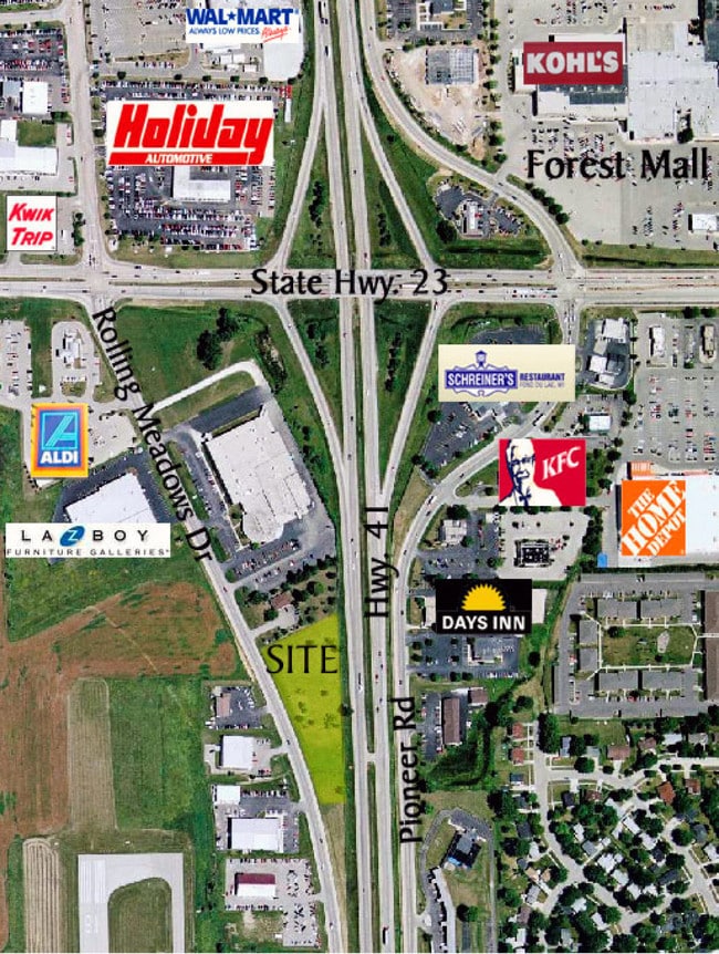


Property Detail
131 N Rolling Meadows Dr
FDL-15-17-08-44-757-00
S8 T15N R17E LOT 2 CSM #7558-55-64 LOC IN SE 1/4 SE 1/4 (F/K/A PART OF LOT 4 CSM #2655-14-75)
Storebuilding
Fond du Lac
B-5
Wisconsin
B and X Area of moderate flood hazard, usually the area between the limits of the 100-year and 500-year floods.
2,4
2025
0.78 AC
2025
Fond du Lac
040700
Milwaukee/Madison
2,800 SF
Fond du Lac, WI
NEARBY LISTINGS FOR SALE OR LEASE
DEMOGRAPHICS near 131 N Rolling Meadows Dr
1 mile
3 mile
5 mile
2025 Total Population
6,494
40,109
56,136
2030 Population
6,524
40,053
56,175
Pop Growth 2025-2030
+ 0.46%
(0.14%)
+ 0.07%
Average Age
40
40
41
2025 Total Households
3,209
17,526
24,010
HH Growth 2025-2030
+ 0.56%
(0.13%)
+ 0.08%
Median Household Inc
$53,520
$57,969
$62,773
Avg Household Size
2.00
2.20
2.20
2025 Avg HH Vehicles
1.00
2.00
2.00
Median Home Value
$157,157
$160,363
$192,346
Median Year Built
1978
1963
1971
Nearby Places
Map Layers
Map Styles
 Street
 Aerial
Transit
 Traffic
 Biking
Places
Listings with unknown addresses are not visible on the map
- Restaurants
- Banks
- Shops
- Fitness
- Groceries
PUBLIC TRANSPORTATION
AIRPORT
Appleton International
Drive
Walk
Distance
Appleton International
52 min
43.0 mi
Nearby Properties
Address
Land Use
TOTAL SIZE
Lot Size
Zoning
Address
Land Use
TOTAL SIZE
Lot Size
Zoning
33.87 AC
Address
Land Use
TOTAL SIZE
Lot Size
Zoning
12.78 AC
Address
Land Use
TOTAL SIZE
Lot Size
Zoning
80.82 AC
Address
Land Use
TOTAL SIZE
Lot Size
Zoning
28.53 AC
Address
Land Use
TOTAL SIZE
Lot Size
Zoning
19,542 SF
12.89 AC
O
Address
Land Use
TOTAL SIZE
Lot Size
Zoning
17,798 SF
17.69 AC
M-2
Address
Land Use
TOTAL SIZE
Lot Size
Zoning
3,952 SF
15.05 AC
R-5
Address
Land Use
TOTAL SIZE
Lot Size
Zoning
2,520 SF
16.04 AC
R-4
Address
Land Use
TOTAL SIZE
Lot Size
Zoning
Address
Land Use
TOTAL SIZE
Lot Size
Zoning
Address
Land Use
TOTAL SIZE
Lot Size
Zoning
121,500 SF
19.42 AC
M-2
Address
Land Use
TOTAL SIZE
Lot Size
Zoning
21,135 SF
12.01 AC
B-5
Address
Land Use
TOTAL SIZE
Lot Size
Zoning
2,986 SF
0.60 AC
B-3
Address
Land Use
TOTAL SIZE
Lot Size
Zoning
141,900 SF
16.24 AC
B-5
Address
Land Use
TOTAL SIZE
Lot Size
Zoning
28.09 AC
M-1
Address
Land Use
TOTAL SIZE
Lot Size
Zoning
17,202 SF
8.86 AC
M-2
Address
Land Use
TOTAL SIZE
Lot Size
Zoning
1,448 SF
10.26 AC
R-5
Address
Land Use
TOTAL SIZE
Lot Size
Zoning
13.38 AC
Address
Land Use
TOTAL SIZE
Lot Size
Zoning
64,570 SF
9.58 AC
B-4
Address
Land Use
TOTAL SIZE
Lot Size
Zoning
10,433 SF
6.77 AC
B-5
Address
Land Use
TOTAL SIZE
Lot Size
Zoning
7,000 SF
7.88 AC
R-4
Address
Land Use
TOTAL SIZE
Lot Size
Zoning
112,900 SF
10 AC
B-5
Address
Land Use
TOTAL SIZE
Lot Size
Zoning
75,000 SF
16.12 AC
M-2
Address
Land Use
TOTAL SIZE
Lot Size
Zoning
Address
Land Use
TOTAL SIZE
Lot Size
Zoning
20.93 AC
M-2
Address
Land Use
TOTAL SIZE
Lot Size
Zoning
9,428 SF
8.71 AC
R-5
Address
Land Use
TOTAL SIZE
Lot Size
Zoning
215,000 SF
8.25 AC
M-2
Address
Land Use
TOTAL SIZE
Lot Size
Zoning
11.78 AC
M-2
Address
Land Use
TOTAL SIZE
Lot Size
Zoning
The World's #1 Commercial Real Estate Marketplace
Connect with us
© 2026 CoStar Group
The information above has been obtained from sources believed reliable. While we do not doubt its accuracy we have not verified it and make no guarantee, warranty or representation about it. It is your responsibility to independently confirm its accuracy and completeness. Any projections, opinions, assumptions, or estimates used are for example only and do not represent the current or future performance of the property. The value of this transaction to you depends on tax and other factors which should be evaluated by your tax, financial, and legal advisors. You and your advisors should conduct a careful, independent investigation of the property to determine to your satisfaction the suitability of the property for your needs.