Property Record
11301 State Hwy, Crown Point, IN 46307
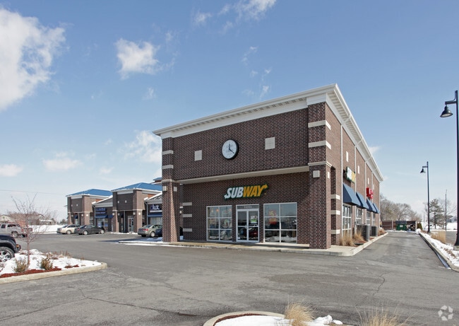

Property Detail
11301 State Hwy
Chicago-Naperville-Elgin, IL-IN
COES CORNER UNIT 1( RESUB. OF LOT 1) LOT 1 EX. PT. OF W.11.13FT. IN R/W
45-16-10-302-003.000-042
LAKE
Regionalshoppingcenterormallwithanchorstore
Indiana
AE The base floodplain where base flood elevations are provided. AE Zones are now used on new format FIRMs instead of A1-A30 Zones.
1
2024
1.87 AC
2025
Indiana
043003
Chicago
16,858 SF
NEARBY LISTINGS FOR SALE OR LEASE
DEMOGRAPHICS near 11301 State Hwy
1 mile
3 mile
5 mile
2025 Total Population
5,680
35,328
64,454
2030 Population
5,720
35,508
64,851
Pop Growth 2025-2030
+ 0.70%
+ 0.51%
+ 0.62%
Average Age
41
42
42
2025 Total Households
2,288
13,535
24,870
HH Growth 2025-2030
+ 0.57%
+ 0.48%
+ 0.58%
Median Household Inc
$102,606
$102,540
$97,028
Avg Household Size
2.50
2.50
2.50
2025 Avg HH Vehicles
2.00
2.00
2.00
Median Home Value
$279,502
$289,818
$286,684
Median Year Built
2002
1990
1993
Nearby Places
Map Layers
Map Styles
 Street
 Aerial
Layers
 Traffic
 Biking
Places
Listings with unknown addresses are not visible on the map
- Restaurants
- Banks
- Shops
- Fitness
- Groceries
PUBLIC TRANSPORTATION
AIRPORT
Chicago Midway International
Drive
Walk
Distance
Chicago Midway International
67 min
45.7 mi
SALE & LEASE HISTORY
LISTING DATE
SALE/LEASE

Mar 13, 2025
For Lease
Feb 11, 2026
For Lease
Feb 01, 2018
For Lease
Dec 02, 2021
For Lease
Apr 30, 2024
For Lease
Nearby Properties
Address
Land Use
TOTAL SIZE
Lot Size
Zoning
Address
Land Use
TOTAL SIZE
Lot Size
Zoning
565,253 SF
59.49 AC
Address
Land Use
TOTAL SIZE
Lot Size
Zoning
1,002,000 SF
60.96 AC
Address
Land Use
TOTAL SIZE
Lot Size
Zoning
639,951 SF
37.52 AC
Address
Land Use
TOTAL SIZE
Lot Size
Zoning
427,836 SF
54.72 AC
Address
Land Use
TOTAL SIZE
Lot Size
Zoning
129,204 SF
16.57 AC
Address
Land Use
TOTAL SIZE
Lot Size
Zoning
184,544 SF
16.76 AC
Address
Land Use
TOTAL SIZE
Lot Size
Zoning
276,540 SF
21.16 AC
Address
Land Use
TOTAL SIZE
Lot Size
Zoning
263,968 SF
27.86 AC
Address
Land Use
TOTAL SIZE
Lot Size
Zoning
111,453 SF
15.21 AC
Address
Land Use
TOTAL SIZE
Lot Size
Zoning
258,560 SF
17.30 AC
Address
Land Use
TOTAL SIZE
Lot Size
Zoning
304,425 SF
18.45 AC
Address
Land Use
TOTAL SIZE
Lot Size
Zoning
133,291 SF
R33
Address
Land Use
TOTAL SIZE
Lot Size
Zoning
143,060 SF
33.82 AC
Address
Land Use
TOTAL SIZE
Lot Size
Zoning
63,992 SF
8.07 AC
Address
Land Use
TOTAL SIZE
Lot Size
Zoning
40,890 SF
11.27 AC
Address
Land Use
TOTAL SIZE
Lot Size
Zoning
89,578 SF
2.59 AC
Address
Land Use
TOTAL SIZE
Lot Size
Zoning
113,353 SF
12.89 AC
Address
Land Use
TOTAL SIZE
Lot Size
Zoning
84,143 SF
14.88 AC
R33
Address
Land Use
TOTAL SIZE
Lot Size
Zoning
92,823 SF
8.56 AC
Address
Land Use
TOTAL SIZE
Lot Size
Zoning
94,527 SF
6.10 AC
R33
Address
Land Use
TOTAL SIZE
Lot Size
Zoning
61,318 SF
15.79 AC
R33
Address
Land Use
TOTAL SIZE
Lot Size
Zoning
122,908 SF
9.58 AC
Address
Land Use
TOTAL SIZE
Lot Size
Zoning
55,149 SF
2.76 AC
Address
Land Use
TOTAL SIZE
Lot Size
Zoning
59,824 SF
5.29 AC
R33
Address
Land Use
TOTAL SIZE
Lot Size
Zoning
57,664 SF
17.81 AC
R33
Address
Land Use
TOTAL SIZE
Lot Size
Zoning
71,786 SF
9.20 AC
R33
Address
Land Use
TOTAL SIZE
Lot Size
Zoning
63,336 SF
4.55 AC
R33
Address
Land Use
TOTAL SIZE
Lot Size
Zoning
48,658 SF
6.64 AC
R33
Address
Land Use
TOTAL SIZE
Lot Size
Zoning
83,090 SF
18.29 AC
R33
Address
Land Use
TOTAL SIZE
Lot Size
Zoning
51,804 SF
4.76 AC
The World's #1 Commercial Real Estate Marketplace
Connect with us
© 2026 CoStar Group
The information above has been obtained from sources believed reliable. While we do not doubt its accuracy we have not verified it and make no guarantee, warranty or representation about it. It is your responsibility to independently confirm its accuracy and completeness. Any projections, opinions, assumptions, or estimates used are for example only and do not represent the current or future performance of the property. The value of this transaction to you depends on tax and other factors which should be evaluated by your tax, financial, and legal advisors. You and your advisors should conduct a careful, independent investigation of the property to determine to your satisfaction the suitability of the property for your needs.