Property Record
298 Garlington Rd, Greenville, SC 29615
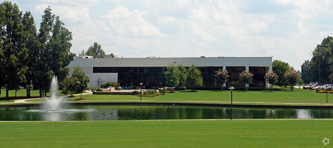


Property Detail
298 Garlington Rd
Greenville-Anderson-Greer, SC
MAP 0547.03
0547.03-01-001.01
GREENVILLE
Lightindustrial
South Carolina
I1
001.01
AE The base floodplain where base flood elevations are provided. AE Zones are now used on new format FIRMs instead of A1-A30 Zones.
223.09 AC
2025
Woodruff/I-385 Corridor
2025
Greenville/Spartanburg
002804
NEARBY LISTINGS FOR SALE OR LEASE
DEMOGRAPHICS near 298 Garlington Rd
1 mile
3 mile
5 mile
2024 Total Population
5,620
54,339
155,566
2029 Population
6,013
58,485
167,215
Pop Growth 2024-2029
+ 6.99%
+ 7.63%
+ 7.49%
Average Age
40
41
40
2024 Total Households
2,716
23,229
64,895
HH Growth 2024-2029
+ 7.22%
+ 7.99%
+ 7.78%
Median Household Inc
$74,615
$96,202
$93,551
Avg Household Size
2.10
2.30
2.40
2024 Avg HH Vehicles
2.00
2.00
2.00
Median Home Value
$430,779
$426,246
$385,521
Median Year Built
1993
1996
1994
Nearby Places
Map Layers
Map Styles
 Street
 Aerial
Transit
 Traffic
 Biking
Places
Listings with unknown addresses are not visible on the map
- Restaurants
- Banks
- Shops
- Fitness
- Groceries
PUBLIC TRANSPORTATION
COMMUTER RAIL
Greenville Amtrak Station (Crescent - Amtrak)
Drive
Walk
Distance
Greenville Amtrak Station (Crescent - Amtrak)
16 min
9.9 mi
AIRPORT
Greenville Spartanburg International
Drive
Walk
Distance
Greenville Spartanburg International
16 min
7.1 mi
Freight Ports
North Charleston Terminal
Drive
Walk
Distance
North Charleston Terminal
223 min
198.4 mi
Nearby Properties
Address
Land Use
TOTAL SIZE
Lot Size
Zoning
Address
Land Use
TOTAL SIZE
Lot Size
Zoning
17.56 AC
C3
Address
Land Use
TOTAL SIZE
Lot Size
Zoning
0.73 AC
C3
Address
Land Use
TOTAL SIZE
Lot Size
Zoning
1.43 AC
OD
Address
Land Use
TOTAL SIZE
Lot Size
Zoning
39.84 AC
OD
Address
Land Use
TOTAL SIZE
Lot Size
Zoning
17.07 AC
S1
Address
Land Use
TOTAL SIZE
Lot Size
Zoning
1 AC
OD
Address
Land Use
TOTAL SIZE
Lot Size
Zoning
181.61 AC
C-2,I1
Address
Land Use
TOTAL SIZE
Lot Size
Zoning
18.55 AC
RS
Address
Land Use
TOTAL SIZE
Lot Size
Zoning
22.50 AC
S1
Address
Land Use
TOTAL SIZE
Lot Size
Zoning
0.47 AC
OD
Address
Land Use
TOTAL SIZE
Lot Size
Zoning
6.86 AC
S1
Address
Land Use
TOTAL SIZE
Lot Size
Zoning
2,355 SF
10.21 AC
RS
Address
Land Use
TOTAL SIZE
Lot Size
Zoning
10.07 AC
S1
Address
Land Use
TOTAL SIZE
Lot Size
Zoning
Address
Land Use
TOTAL SIZE
Lot Size
Zoning
10.29 AC
S1
Address
Land Use
TOTAL SIZE
Lot Size
Zoning
3.38 AC
S1
Address
Land Use
TOTAL SIZE
Lot Size
Zoning
9.10 AC
RM,C2
Address
Land Use
TOTAL SIZE
Lot Size
Zoning
5.83 AC
S1
Address
Land Use
TOTAL SIZE
Lot Size
Zoning
20.40 AC
RS
Address
Land Use
TOTAL SIZE
Lot Size
Zoning
11.05 AC
S1
Address
Land Use
TOTAL SIZE
Lot Size
Zoning
18.50 AC
PD
Address
Land Use
TOTAL SIZE
Lot Size
Zoning
17.53 AC
I1
Address
Land Use
TOTAL SIZE
Lot Size
Zoning
6.27 AC
UVD
Address
Land Use
TOTAL SIZE
Lot Size
Zoning
10.36 AC
R12
Address
Land Use
TOTAL SIZE
Lot Size
Zoning
3.24 AC
S1
Address
Land Use
TOTAL SIZE
Lot Size
Zoning
37.35 AC
S1
Address
Land Use
TOTAL SIZE
Lot Size
Zoning
39.85 AC
C3
Address
Land Use
TOTAL SIZE
Lot Size
Zoning
26.75 AC
S1
Address
Land Use
TOTAL SIZE
Lot Size
Zoning
The World's #1 Commercial Real Estate Marketplace
Connect with us
© 2026 CoStar Group
The information above has been obtained from sources believed reliable. While we do not doubt its accuracy we have not verified it and make no guarantee, warranty or representation about it. It is your responsibility to independently confirm its accuracy and completeness. Any projections, opinions, assumptions, or estimates used are for example only and do not represent the current or future performance of the property. The value of this transaction to you depends on tax and other factors which should be evaluated by your tax, financial, and legal advisors. You and your advisors should conduct a careful, independent investigation of the property to determine to your satisfaction the suitability of the property for your needs.