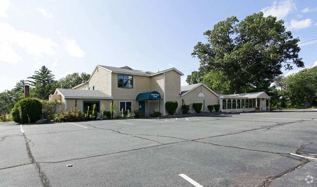
Property Record
92 Route 125, Kingston, NH 03848

Property Detail
92 Route 125
Commercialbuilding
Rockingham
C3AQC3
New Hampshire
A Areas with a 1% annual chance of flooding and a 26% chance of flooding over the life of a 30-year mortgage.
1.86 AC
2025
Rockingham
2025
Boston
105100
Boston-Cambridge-Newton, MA-NH
10,710 SF
KNGS-000008-000040-000000-R000000
NEARBY LISTINGS FOR SALE OR LEASE
-
-
View all Kingston listings for sale on LoopNet.com
DEMOGRAPHICS near 92 Route 125
1 mile
3 mile
5 mile
2025 Total Population
1,006
11,356
34,469
2030 Population
1,020
11,340
34,650
Pop Growth 2025-2030
+ 1.39%
(0.14%)
+ 0.53%
Average Age
44
44
44
2025 Total Households
370
4,501
13,426
HH Growth 2025-2030
+ 1.08%
(0.31%)
+ 0.37%
Median Household Inc
$111,718
$115,730
$118,754
Avg Household Size
2.60
2.50
2.50
2025 Avg HH Vehicles
2.00
2.00
2.00
Median Home Value
$471,211
$463,708
$490,974
Median Year Built
1983
1984
1983
Nearby Places
Map Layers
Map Styles
 Street
 Aerial
Layers
 Traffic
 Biking
Places
Listings with unknown addresses are not visible on the map
- Restaurants
- Banks
- Shops
- Fitness
- Groceries
PUBLIC TRANSPORTATION
COMMUTER RAIL
Haverhill (Haverhill Line - Massachusetts Bay Transportation Authority Commuter Rail (Purple Line))
Drive
Walk
Distance
Haverhill (Haverhill Line - Massachusetts Bay Transportation Authority Commuter Rail (Purple Line))
17 min
9.4 mi
Bradford (Haverhill Line - Massachusetts Bay Transportation Authority Commuter Rail (Purple Line))
Drive
Walk
Distance
Bradford (Haverhill Line - Massachusetts Bay Transportation Authority Commuter Rail (Purple Line))
18 min
9.8 mi
AIRPORT
Portsmouth International at Pease
Drive
Walk
Distance
Portsmouth International at Pease
48 min
27.9 mi
Manchester Boston Regional
Drive
Walk
Distance
Manchester Boston Regional
54 min
31.7 mi
Freight Ports
Port of Boston
Drive
Walk
Distance
Port of Boston
64 min
44.8 mi
SALE & LEASE HISTORY
LISTING DATE
SALE/LEASE

Sep 23, 2016
For Sale
Nearby Properties
Address
Land Use
TOTAL SIZE
Lot Size
Zoning
Address
Land Use
TOTAL SIZE
Lot Size
Zoning
279,958 SF
86 AC
SFRAQ
Address
Land Use
TOTAL SIZE
Lot Size
Zoning
8.79 AC
RRAQ R
Address
Land Use
TOTAL SIZE
Lot Size
Zoning
5,553 SF
44.71 AC
A-RES
Address
Land Use
TOTAL SIZE
Lot Size
Zoning
36.41 AC
RRAQ R
Address
Land Use
TOTAL SIZE
Lot Size
Zoning
39,670 SF
26.55 AC
RES-A
Address
Land Use
TOTAL SIZE
Lot Size
Zoning
25,614 SF
15.39 AC
C1 C
Address
Land Use
TOTAL SIZE
Lot Size
Zoning
79,184 SF
9.96 AC
C-3
Address
Land Use
TOTAL SIZE
Lot Size
Zoning
4,025 SF
45.06 AC
RES-A
Address
Land Use
TOTAL SIZE
Lot Size
Zoning
8,272 SF
10 AC
COMM
Address
Land Use
TOTAL SIZE
Lot Size
Zoning
1,577 SF
122.25 AC
RRAQ R
Address
Land Use
TOTAL SIZE
Lot Size
Zoning
6,300 SF
6.70 AC
C3AQC3
Address
Land Use
TOTAL SIZE
Lot Size
Zoning
66,288 SF
50.31 AC
LIGHT
Address
Land Use
TOTAL SIZE
Lot Size
Zoning
27,362 SF
2.51 AC
C-3
Address
Land Use
TOTAL SIZE
Lot Size
Zoning
9,276 SF
5.50 AC
COMM
Address
Land Use
TOTAL SIZE
Lot Size
Zoning
33,600 SF
10.51 AC
I
Address
Land Use
TOTAL SIZE
Lot Size
Zoning
8,322 SF
4 AC
SFRAQ
Address
Land Use
TOTAL SIZE
Lot Size
Zoning
15,155 SF
12.70 AC
C-3
Address
Land Use
TOTAL SIZE
Lot Size
Zoning
21,645 SF
3.65 AC
I
Address
Land Use
TOTAL SIZE
Lot Size
Zoning
810 SF
20.11 AC
HCLILI
Address
Land Use
TOTAL SIZE
Lot Size
Zoning
35,965 SF
C3AQC3
Address
Land Use
TOTAL SIZE
Lot Size
Zoning
5,836 SF
4.25 AC
MDR
Address
Land Use
TOTAL SIZE
Lot Size
Zoning
7,027 SF
182.50 AC
INDAQI
Address
Land Use
TOTAL SIZE
Lot Size
Zoning
3,476 SF
21 AC
RES-A
Address
Land Use
TOTAL SIZE
Lot Size
Zoning
21.16 AC
RURAL
Address
Land Use
TOTAL SIZE
Lot Size
Zoning
3,810 SF
2.90 AC
C-3
Address
Land Use
TOTAL SIZE
Lot Size
Zoning
3,750 SF
3.63 AC
C-3
Address
Land Use
TOTAL SIZE
Lot Size
Zoning
16,872 SF
1.47 AC
C-3
Address
Land Use
TOTAL SIZE
Lot Size
Zoning
4,336 SF
3.18 AC
A-RES
Address
Land Use
TOTAL SIZE
Lot Size
Zoning
1,761 SF
17.81 AC
RURAL
Address
Land Use
TOTAL SIZE
Lot Size
Zoning
6,689 SF
19.55 AC
C3C3
The World's #1 Commercial Real Estate Marketplace
Connect with us
© 2026 CoStar Group
The information above has been obtained from sources believed reliable. While we do not doubt its accuracy we have not verified it and make no guarantee, warranty or representation about it. It is your responsibility to independently confirm its accuracy and completeness. Any projections, opinions, assumptions, or estimates used are for example only and do not represent the current or future performance of the property. The value of this transaction to you depends on tax and other factors which should be evaluated by your tax, financial, and legal advisors. You and your advisors should conduct a careful, independent investigation of the property to determine to your satisfaction the suitability of the property for your needs.