Property Record
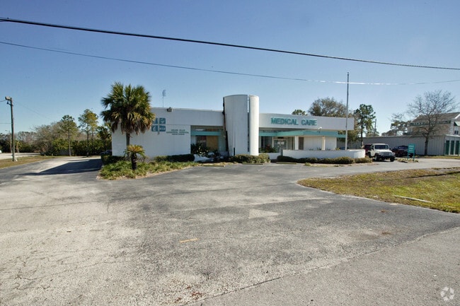
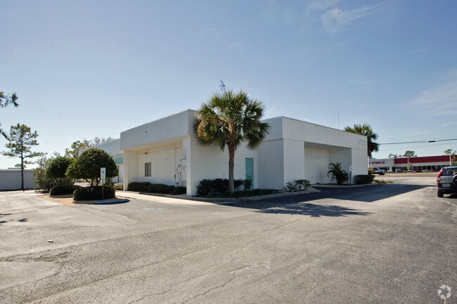
2280 Us Highway 19, Holiday, FL 34691


NEARBY LISTINGS FOR SALE OR LEASE
Property Detail
2280 Us Highway 19
Tampa-St. Petersburg-Clearwater, FL
Tampa And Tarpon Springs Land Co.
30-26-16-0010-04000-0011
TAMPA & TARPON SPRINGS LAND COMPANY PB 1 PGS 68-70 INCL POR OF TRACT 40 DESC AS COM AT INTERSECTION OF PRESENTLY EXISTING R/W LINE OF US HWY 19 & NORTH LINE OF TRACT 40 TH N89DEG07 14E ALG NORTH LINE OF TRACT 40 211.00 FT TH PARALLEL TO EAST R/W LINE
Residentialacreage
Pasco
X
Florida
12101C0353G
11
2024
0.87 AC
2026
Pasco County
030602
Tampa/St Petersburg
5,363 SF
DEMOGRAPHICS near 2280 Us Highway 19
1 Mile
3 Mile
5 Mile
2024 Total Population
17,440
81,473
155,222
2029 Population
21,562
97,107
180,736
Pop Growth 2024-2029
+ 23.64%
+ 19.19%
+ 16.44%
Average Age
45
44
45
2024 Total Households
8,068
34,900
67,043
HH Growth 2024-2029
+ 23.81%
+ 19.30%
+ 16.49%
Median Household Inc
$34,097
$45,630
$49,436
Avg Household Size
2.10
2.30
2.30
2024 Avg HH Vehicles
1.00
2.00
2.00
Median Home Value
$78,396
$154,187
$202,932
Median Year Built
1975
1976
1979
Nearby Places
Map Layers
Map Styles
 Street
 Aerial
- Restaurants
- Banks
- Shops
- Fitness
- Groceries
PUBLIC TRANSPORTATION
AIRPORT
Tampa International
DRIVE
WALK
Distance
Tampa International
44 min
25.8 mi
St Pete-Clearwater International
DRIVE
WALK
Distance
St Pete-Clearwater International
44 min
25.9 mi
Nearby Properties
Address
Land Use
TOTAL SIZE
Lot Size
Zoning
Address
Land Use
TOTAL SIZE
Lot Size
Zoning
384,700 SF
18.90 AC
MF3
Address
Land Use
TOTAL SIZE
Lot Size
Zoning
314,948 SF
55.04 AC
MPUD
Address
Land Use
TOTAL SIZE
Lot Size
Zoning
202,954 SF
49.22 AC
AR
Address
Land Use
TOTAL SIZE
Lot Size
Zoning
333,044 SF
25.64 AC
R4
Address
Land Use
TOTAL SIZE
Lot Size
Zoning
157,476 SF
27.47 AC
MPUD
Address
Land Use
TOTAL SIZE
Lot Size
Zoning
264.64 AC
AC
Address
Land Use
TOTAL SIZE
Lot Size
Zoning
193,971 SF
4.50 AC
C1
Address
Land Use
TOTAL SIZE
Lot Size
Zoning
163,106 SF
13.97 AC
C
Address
Land Use
TOTAL SIZE
Lot Size
Zoning
145,216 SF
7.58 AC
MF3
Address
Land Use
TOTAL SIZE
Lot Size
Zoning
121,869 SF
4.72 AC
C2
Address
Land Use
TOTAL SIZE
Lot Size
Zoning
43,469 SF
11.48 AC
MPUD
Address
Land Use
TOTAL SIZE
Lot Size
Zoning
141,763 SF
12.96 AC
Address
Land Use
TOTAL SIZE
Lot Size
Zoning
81,045 SF
16.34 AC
PUD
Address
Land Use
TOTAL SIZE
Lot Size
Zoning
16,510 SF
41.69 AC
R1
Address
Land Use
TOTAL SIZE
Lot Size
Zoning
77,900 SF
10.52 AC
C2
Address
Land Use
TOTAL SIZE
Lot Size
Zoning
82,047 SF
21.48 AC
MF2
Address
Land Use
TOTAL SIZE
Lot Size
Zoning
80,212 SF
6.64 AC
Address
Land Use
TOTAL SIZE
Lot Size
Zoning
203,135 SF
41.04 AC
C2
Address
Land Use
TOTAL SIZE
Lot Size
Zoning
74,641 SF
9.20 AC
C2
Address
Land Use
TOTAL SIZE
Lot Size
Zoning
77,384 SF
6.32 AC
Address
Land Use
TOTAL SIZE
Lot Size
Zoning
22,216 SF
7.20 AC
C2
Address
Land Use
TOTAL SIZE
Lot Size
Zoning
72,796 SF
2.62 AC
MF3
Address
Land Use
TOTAL SIZE
Lot Size
Zoning
65,939 SF
7.23 AC
C2
Address
Land Use
TOTAL SIZE
Lot Size
Zoning
90,892 SF
8.80 AC
Address
Land Use
TOTAL SIZE
Lot Size
Zoning
73.65 AC
AE
Address
Land Use
TOTAL SIZE
Lot Size
Zoning
91,835 SF
6.82 AC
C2
Address
Land Use
TOTAL SIZE
Lot Size
Zoning
86,060 SF
7.84 AC
M1
Address
Land Use
TOTAL SIZE
Lot Size
Zoning
46,897 SF
5.44 AC
C2
Address
Land Use
TOTAL SIZE
Lot Size
Zoning
125,834 SF
11.21 AC
C2
Address
Land Use
TOTAL SIZE
Lot Size
Zoning
41,083 SF
1.99 AC
The World's #1 Commercial Real Estate Marketplace
Connect with us
© 2026 CoStar Group
The information above has been obtained from sources believed reliable. While we do not doubt its accuracy we have not verified it and make no guarantee, warranty or representation about it. It is your responsibility to independently confirm its accuracy and completeness. Any projections, opinions, assumptions, or estimates used are for example only and do not represent the current or future performance of the property. The value of this transaction to you depends on tax and other factors which should be evaluated by your tax, financial, and legal advisors. You and your advisors should conduct a careful, independent investigation of the property to determine to your satisfaction the suitability of the property for your needs.