Property Record
20 Fairway Xing, Shelbyville, KY 40065
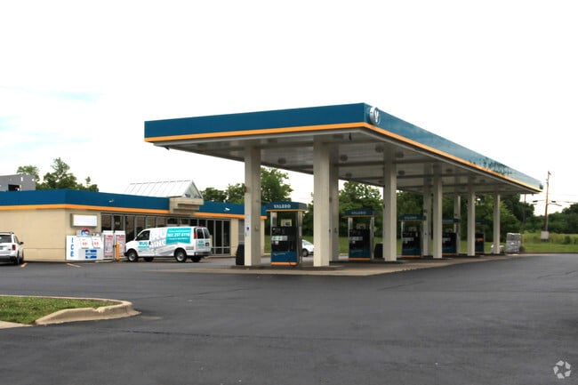

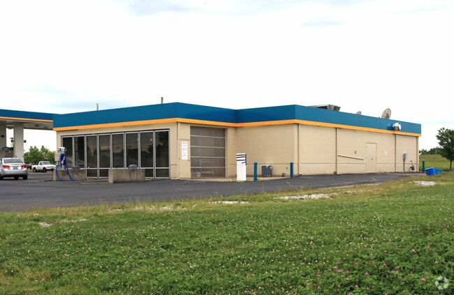

Property Detail
20 Fairway Xing
Louisville/Jefferson County, KY-IN
AMD FAIRWAY CROSSING REMAINDER OF TR 2
052-00-001D
Shelby
Commercialnec
Kentucky
RESIDENTIA
1-2
B and X Area of moderate flood hazard, usually the area between the limits of the 100-year and 500-year floods.
1.45 AC
2025
Shelby County
2025
Louisville
040402
NEARBY LISTINGS FOR SALE OR LEASE
DEMOGRAPHICS near 20 Fairway Xing
1 mile
3 mile
5 mile
2025 Total Population
5,372
18,918
30,165
2030 Population
5,588
19,709
31,428
Pop Growth 2025-2030
+ 4.02%
+ 4.18%
+ 4.19%
Average Age
37
38
38
2025 Total Households
1,922
7,239
11,388
HH Growth 2025-2030
+ 4.16%
+ 4.23%
+ 4.29%
Median Household Inc
$100,320
$75,127
$74,162
Avg Household Size
2.80
2.50
2.60
2025 Avg HH Vehicles
2.00
2.00
2.00
Median Home Value
$272,009
$250,288
$269,818
Median Year Built
2002
1990
1992
Nearby Places
Map Layers
Map Styles
 Street
 Aerial
Transit
 Traffic
 Biking
Places
Listings with unknown addresses are not visible on the map
- Restaurants
- Banks
- Shops
- Fitness
- Groceries
PUBLIC TRANSPORTATION
AIRPORT
Louisville Muhammad Ali International
Drive
Walk
Distance
Louisville Muhammad Ali International
46 min
34.4 mi
Blue Grass
Drive
Walk
Distance
Blue Grass
49 min
39.6 mi
Nearby Properties
Address
Land Use
TOTAL SIZE
Lot Size
Zoning
Address
Land Use
TOTAL SIZE
Lot Size
Zoning
21.63 AC
RESIDENTIA
Address
Land Use
TOTAL SIZE
Lot Size
Zoning
0.49 AC
Address
Land Use
TOTAL SIZE
Lot Size
Zoning
7.94 AC
Address
Land Use
TOTAL SIZE
Lot Size
Zoning
Address
Land Use
TOTAL SIZE
Lot Size
Zoning
Address
Land Use
TOTAL SIZE
Lot Size
Zoning
18.79 AC
RESIDENTIA
Address
Land Use
TOTAL SIZE
Lot Size
Zoning
53,107 SF
60 AC
COMMERCIAL
Address
Land Use
TOTAL SIZE
Lot Size
Zoning
Address
Land Use
TOTAL SIZE
Lot Size
Zoning
11.80 AC
COMMERCIAL
Address
Land Use
TOTAL SIZE
Lot Size
Zoning
9.89 AC
Address
Land Use
TOTAL SIZE
Lot Size
Zoning
Address
Land Use
TOTAL SIZE
Lot Size
Zoning
2.80 AC
Address
Land Use
TOTAL SIZE
Lot Size
Zoning
43,161 SF
2.18 AC
RESIDENTIA
Address
Land Use
TOTAL SIZE
Lot Size
Zoning
Address
Land Use
TOTAL SIZE
Lot Size
Zoning
Address
Land Use
TOTAL SIZE
Lot Size
Zoning
10,092 SF
4 AC
COM
Address
Land Use
TOTAL SIZE
Lot Size
Zoning
2.41 AC
COMMERCIAL
Address
Land Use
TOTAL SIZE
Lot Size
Zoning
5.93 AC
COMMERCIAL
Address
Land Use
TOTAL SIZE
Lot Size
Zoning
Address
Land Use
TOTAL SIZE
Lot Size
Zoning
Address
Land Use
TOTAL SIZE
Lot Size
Zoning
Address
Land Use
TOTAL SIZE
Lot Size
Zoning
Address
Land Use
TOTAL SIZE
Lot Size
Zoning
Address
Land Use
TOTAL SIZE
Lot Size
Zoning
5.61 AC
Address
Land Use
TOTAL SIZE
Lot Size
Zoning
Address
Land Use
TOTAL SIZE
Lot Size
Zoning
Address
Land Use
TOTAL SIZE
Lot Size
Zoning
45.12 AC
OTHER
Address
Land Use
TOTAL SIZE
Lot Size
Zoning
92.30 AC
Address
Land Use
TOTAL SIZE
Lot Size
Zoning
1.99 AC
COMMERCIAL
Address
Land Use
TOTAL SIZE
Lot Size
Zoning
151.44 AC
RESIDENTIA
The World's #1 Commercial Real Estate Marketplace
Connect with us
© 2026 CoStar Group
The information above has been obtained from sources believed reliable. While we do not doubt its accuracy we have not verified it and make no guarantee, warranty or representation about it. It is your responsibility to independently confirm its accuracy and completeness. Any projections, opinions, assumptions, or estimates used are for example only and do not represent the current or future performance of the property. The value of this transaction to you depends on tax and other factors which should be evaluated by your tax, financial, and legal advisors. You and your advisors should conduct a careful, independent investigation of the property to determine to your satisfaction the suitability of the property for your needs.