Property Record
2413 Dawes Rd, Mobile, AL 36695
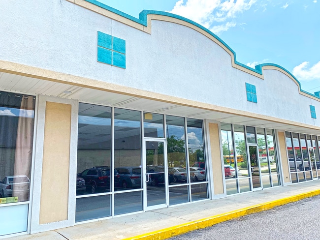

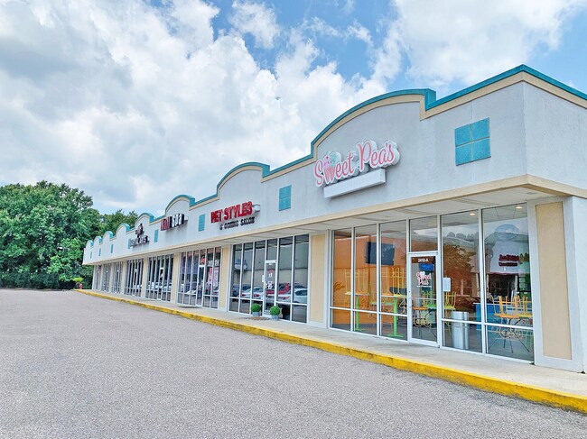
Property Detail
2413 Dawes Rd
Mobile, AL
LOTS 10 & 11 AIRPORT MANOR MBK 9/275 LESS AND EXCEPT THAT PART INTO DAWES ROAD.
34-01-02-0-001-019
MOBILE
Storesoffices
Alabama
B and X Area of moderate flood hazard, usually the area between the limits of the 100-year and 500-year floods.
10-11
2025
0.91 AC
2025
Outlying Mobile County
006408
Mobile
9,660 SF
NEARBY LISTINGS FOR SALE OR LEASE
DEMOGRAPHICS near 2413 Dawes Rd
1 mile
3 mile
5 mile
2025 Total Population
6,185
35,986
86,408
2030 Population
6,004
35,032
84,786
Pop Growth 2025-2030
(2.93%)
(2.65%)
(1.88%)
Average Age
40
40
40
2025 Total Households
2,322
13,548
34,968
HH Growth 2025-2030
(3.06%)
(2.69%)
(1.92%)
Median Household Inc
$94,890
$87,187
$68,256
Avg Household Size
2.60
2.60
2.40
2025 Avg HH Vehicles
2.00
2.00
2.00
Median Home Value
$263,559
$266,274
$247,782
Median Year Built
1999
1996
1991
Nearby Places
Map Layers
Map Styles
 Street
 Aerial
Transit
 Traffic
 Biking
Places
Listings with unknown addresses are not visible on the map
- Restaurants
- Banks
- Shops
- Fitness
- Groceries
PUBLIC TRANSPORTATION
AIRPORT
Mobile Regional
Drive
Walk
Distance
Mobile Regional
15 min
6.0 mi
Mobile International
Drive
Walk
Distance
Mobile International
29 min
16.8 mi
Freight Ports
Port of Mobile
Drive
Walk
Distance
Port of Mobile
32 min
16.4 mi
SALE & LEASE HISTORY
LISTING DATE
SALE/LEASE

Sep 25, 2016
For Lease
Mar 29, 2019
For Lease
Dec 09, 2019
For Lease
Nearby Properties
Address
Land Use
TOTAL SIZE
Lot Size
Zoning
Address
Land Use
TOTAL SIZE
Lot Size
Zoning
32,394 SF
40 AC
Address
Land Use
TOTAL SIZE
Lot Size
Zoning
230,009 SF
97.56 AC
Address
Land Use
TOTAL SIZE
Lot Size
Zoning
250,368 SF
317 AC
Address
Land Use
TOTAL SIZE
Lot Size
Zoning
27,732 SF
34 AC
Address
Land Use
TOTAL SIZE
Lot Size
Zoning
6,172 SF
23.43 AC
Address
Land Use
TOTAL SIZE
Lot Size
Zoning
88,588 SF
13.01 AC
Address
Land Use
TOTAL SIZE
Lot Size
Zoning
31,608 SF
20.30 AC
Address
Land Use
TOTAL SIZE
Lot Size
Zoning
75,388 SF
639.67 AC
Address
Land Use
TOTAL SIZE
Lot Size
Zoning
179,142 SF
17.12 AC
Address
Land Use
TOTAL SIZE
Lot Size
Zoning
200,001 SF
20 AC
Address
Land Use
TOTAL SIZE
Lot Size
Zoning
280.05 AC
Address
Land Use
TOTAL SIZE
Lot Size
Zoning
185,520 SF
50.74 AC
Address
Land Use
TOTAL SIZE
Lot Size
Zoning
4,958 SF
14.09 AC
Address
Land Use
TOTAL SIZE
Lot Size
Zoning
60,138 SF
10.45 AC
Address
Land Use
TOTAL SIZE
Lot Size
Zoning
128,832 SF
18.79 AC
Address
Land Use
TOTAL SIZE
Lot Size
Zoning
15,756 SF
6.20 AC
Address
Land Use
TOTAL SIZE
Lot Size
Zoning
159,221 SF
24.12 AC
Address
Land Use
TOTAL SIZE
Lot Size
Zoning
20,022 SF
7.47 AC
Address
Land Use
TOTAL SIZE
Lot Size
Zoning
122,601 SF
9.90 AC
Address
Land Use
TOTAL SIZE
Lot Size
Zoning
48,442 SF
7.25 AC
Address
Land Use
TOTAL SIZE
Lot Size
Zoning
37,894 SF
40 AC
Address
Land Use
TOTAL SIZE
Lot Size
Zoning
12,576 SF
26 AC
Address
Land Use
TOTAL SIZE
Lot Size
Zoning
74,969 SF
3.52 AC
Address
Land Use
TOTAL SIZE
Lot Size
Zoning
112,773 SF
12.70 AC
Address
Land Use
TOTAL SIZE
Lot Size
Zoning
89,042 SF
8.04 AC
Address
Land Use
TOTAL SIZE
Lot Size
Zoning
69,131 SF
10.89 AC
Address
Land Use
TOTAL SIZE
Lot Size
Zoning
78,119 SF
20 AC
Address
Land Use
TOTAL SIZE
Lot Size
Zoning
10,320 SF
7.51 AC
Address
Land Use
TOTAL SIZE
Lot Size
Zoning
65,656 SF
28.82 AC
Address
Land Use
TOTAL SIZE
Lot Size
Zoning
43,486 SF
5 AC
The World's #1 Commercial Real Estate Marketplace
Connect with us
© 2026 CoStar Group
The information above has been obtained from sources believed reliable. While we do not doubt its accuracy we have not verified it and make no guarantee, warranty or representation about it. It is your responsibility to independently confirm its accuracy and completeness. Any projections, opinions, assumptions, or estimates used are for example only and do not represent the current or future performance of the property. The value of this transaction to you depends on tax and other factors which should be evaluated by your tax, financial, and legal advisors. You and your advisors should conduct a careful, independent investigation of the property to determine to your satisfaction the suitability of the property for your needs.