Property Record
118 Crossway Rd, Tallahassee, FL 32305
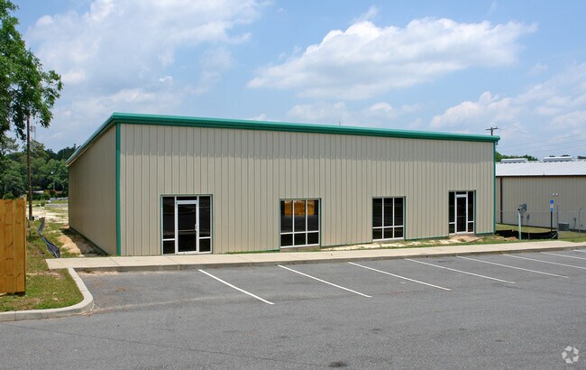


Property Detail
118 Crossway Rd
Tallahassee, FL
Unplatted Land
41-24-20-494-002.0
24 1S 1W IN SE 1/4 BEING LOT 2 OF A 10 LOT LP OR 550/738 1883/1408 96-253PR 2911/775(LP) OR 1895/888WILL 1962/68 1550 OR 1967/59
Warehouse
Leon
X
Florida
12073C0293F
2
2025
0.47 AC
2025
Southwest Leon County
001804
Tallahassee
4,200 SF
NEARBY LISTINGS FOR SALE OR LEASE
DEMOGRAPHICS near 118 Crossway Rd
1 mile
3 mile
5 mile
2024 Total Population
4,782
23,394
83,725
2029 Population
5,124
24,824
88,013
Pop Growth 2024-2029
+ 7.15%
+ 6.11%
+ 5.12%
Average Age
36
35
33
2024 Total Households
1,941
9,179
35,007
HH Growth 2024-2029
+ 7.32%
+ 6.19%
+ 5.47%
Median Household Inc
$42,692
$43,090
$41,574
Avg Household Size
2.40
2.40
2.10
2024 Avg HH Vehicles
1.00
1.00
2.00
Median Home Value
$125,815
$131,887
$174,712
Median Year Built
1991
1980
1985
Nearby Places
Map Layers
Map Styles
 Street
 Aerial
Transit
 Traffic
 Biking
Places
Listings with unknown addresses are not visible on the map
- Restaurants
- Banks
- Shops
- Fitness
- Groceries
PUBLIC TRANSPORTATION
AIRPORT
Tallahassee International
Drive
Walk
Distance
Tallahassee International
10 min
5.4 mi
SALE & LEASE HISTORY
LISTING DATE
SALE/LEASE

Dec 13, 2019
For Lease
Nearby Properties
Address
Land Use
TOTAL SIZE
Lot Size
Zoning
Address
Land Use
TOTAL SIZE
Lot Size
Zoning
807,298 SF
145.81 AC
UT
Address
Land Use
TOTAL SIZE
Lot Size
Zoning
602,388 SF
34.48 AC
Address
Land Use
TOTAL SIZE
Lot Size
Zoning
200,705 SF
31.57 AC
Address
Land Use
TOTAL SIZE
Lot Size
Zoning
636,937 SF
20.54 AC
Address
Land Use
TOTAL SIZE
Lot Size
Zoning
292,562 SF
26.64 AC
Address
Land Use
TOTAL SIZE
Lot Size
Zoning
837,070 SF
24.41 AC
MR1
Address
Land Use
TOTAL SIZE
Lot Size
Zoning
160,777 SF
12.50 AC
OR3
Address
Land Use
TOTAL SIZE
Lot Size
Zoning
450,776 SF
256.11 AC
M1
Address
Land Use
TOTAL SIZE
Lot Size
Zoning
274,488 SF
32.53 AC
RP2
Address
Land Use
TOTAL SIZE
Lot Size
Zoning
141,257 SF
16.85 AC
CU45
Address
Land Use
TOTAL SIZE
Lot Size
Zoning
271,878 SF
8.85 AC
CU26
Address
Land Use
TOTAL SIZE
Lot Size
Zoning
110,000 SF
8.79 AC
CU18
Address
Land Use
TOTAL SIZE
Lot Size
Zoning
225,454 SF
7.45 AC
CU45
Address
Land Use
TOTAL SIZE
Lot Size
Zoning
287,890 SF
10 AC
CU18
Address
Land Use
TOTAL SIZE
Lot Size
Zoning
262,405 SF
106.61 AC
OS
Address
Land Use
TOTAL SIZE
Lot Size
Zoning
76,233 SF
15.04 AC
CP
Address
Land Use
TOTAL SIZE
Lot Size
Zoning
29,584 SF
2.50 AC
CU45
Address
Land Use
TOTAL SIZE
Lot Size
Zoning
277,579 SF
9.31 AC
MR1
Address
Land Use
TOTAL SIZE
Lot Size
Zoning
116,830 SF
34.12 AC
RP2
Address
Land Use
TOTAL SIZE
Lot Size
Zoning
48,620 SF
10 AC
Address
Land Use
TOTAL SIZE
Lot Size
Zoning
289,500 SF
5.97 AC
CU45
Address
Land Use
TOTAL SIZE
Lot Size
Zoning
41.43 AC
R3
Address
Land Use
TOTAL SIZE
Lot Size
Zoning
155,079 SF
6.80 AC
CU45
Address
Land Use
TOTAL SIZE
Lot Size
Zoning
94,118 SF
22.23 AC
MR1
Address
Land Use
TOTAL SIZE
Lot Size
Zoning
194,506 SF
6.57 AC
CU26
Address
Land Use
TOTAL SIZE
Lot Size
Zoning
181,674 SF
8.72 AC
CU18
Address
Land Use
TOTAL SIZE
Lot Size
Zoning
31,335 SF
51.51 AC
RP2
Address
Land Use
TOTAL SIZE
Lot Size
Zoning
144,399 SF
39.20 AC
MH
Address
Land Use
TOTAL SIZE
Lot Size
Zoning
192,136 SF
7.81 AC
CU45
Address
Land Use
TOTAL SIZE
Lot Size
Zoning
188,592 SF
8.23 AC
CU18
The World's #1 Commercial Real Estate Marketplace
Connect with us
© 2026 CoStar Group
The information above has been obtained from sources believed reliable. While we do not doubt its accuracy we have not verified it and make no guarantee, warranty or representation about it. It is your responsibility to independently confirm its accuracy and completeness. Any projections, opinions, assumptions, or estimates used are for example only and do not represent the current or future performance of the property. The value of this transaction to you depends on tax and other factors which should be evaluated by your tax, financial, and legal advisors. You and your advisors should conduct a careful, independent investigation of the property to determine to your satisfaction the suitability of the property for your needs.