Property Record
2995 E Chandler Heights Rd, Chandler, AZ 85249


Property Detail
2995 E Chandler Heights Rd
303-55-675
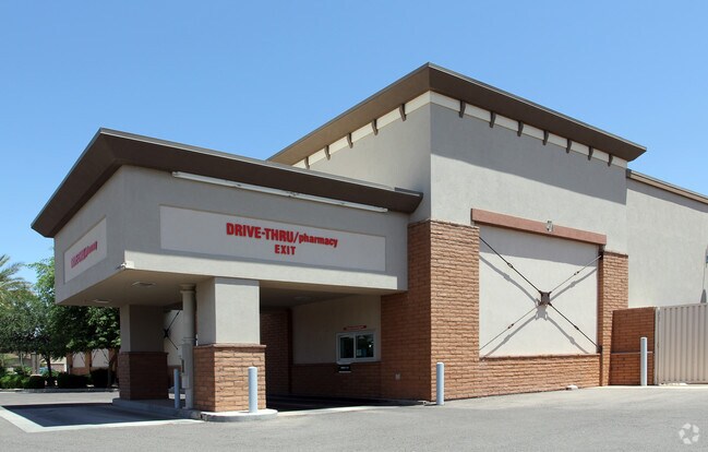
CVS NO 7075 MCR 785-23
Storebuilding
MARICOPA
PAD
Arizona
C and X Area of minimal flood hazard, usually depicted on FIRMs as above the 500-year flood level.
1
2025
1.89 AC
2025
Gilbert
813500
Phoenix
13,013 SF
Phoenix-Mesa-Chandler, AZ
NEARBY LISTINGS FOR SALE OR LEASE
DEMOGRAPHICS near 2995 E Chandler Heights Rd
1 mile
3 mile
5 mile
2025 Total Population
9,952
79,749
182,941
2030 Population
10,350
83,173
190,684
Pop Growth 2025-2030
+ 4.00%
+ 4.29%
+ 4.23%
Average Age
38
40
40
2025 Total Households
2,941
25,565
61,878
HH Growth 2025-2030
+ 4.05%
+ 4.40%
+ 4.31%
Median Household Inc
$204,197
$152,709
$137,911
Avg Household Size
3.30
3.00
2.90
2025 Avg HH Vehicles
3.00
2.00
2.00
Median Home Value
$826,136
$694,144
$664,135
Median Year Built
2006
2006
2005
Nearby Places
Map Layers
Map Styles
 Street
 Aerial
Transit
 Traffic
 Biking
Places
Listings with unknown addresses are not visible on the map
- Restaurants
- Banks
- Shops
- Fitness
- Groceries
PUBLIC TRANSPORTATION
AIRPORT
Phoenix-Mesa Gateway
Drive
Walk
Distance
Phoenix-Mesa Gateway
21 min
11.8 mi
Phoenix Sky Harbor International
Drive
Walk
Distance
Phoenix Sky Harbor International
37 min
26.3 mi
Nearby Properties
Address
Land Use
TOTAL SIZE
Lot Size
Zoning
Address
Land Use
TOTAL SIZE
Lot Size
Zoning
30,414 SF
97.19 AC
PAD
Address
Land Use
TOTAL SIZE
Lot Size
Zoning
288,023 SF
48.20 AC
PAD
Address
Land Use
TOTAL SIZE
Lot Size
Zoning
363,785 SF
46.73 AC
Address
Land Use
TOTAL SIZE
Lot Size
Zoning
262,955 SF
57.93 AC
PF
Address
Land Use
TOTAL SIZE
Lot Size
Zoning
430,700 SF
63.32 AC
PF
Address
Land Use
TOTAL SIZE
Lot Size
Zoning
425,886 SF
19.08 AC
MFM
Address
Land Use
TOTAL SIZE
Lot Size
Zoning
308,238 SF
36.64 AC
PAD
Address
Land Use
TOTAL SIZE
Lot Size
Zoning
180,117 SF
28.41 AC
PF
Address
Land Use
TOTAL SIZE
Lot Size
Zoning
199,808 SF
48.05 AC
PAD
Address
Land Use
TOTAL SIZE
Lot Size
Zoning
316,658 SF
47.91 AC
PAD
Address
Land Use
TOTAL SIZE
Lot Size
Zoning
259,575 SF
16.75 AC
PAD
Address
Land Use
TOTAL SIZE
Lot Size
Zoning
195,297 SF
8.90 AC
SC
Address
Land Use
TOTAL SIZE
Lot Size
Zoning
8,307 SF
234.90 AC
AG
Address
Land Use
TOTAL SIZE
Lot Size
Zoning
271,444 SF
19.90 AC
PAD
Address
Land Use
TOTAL SIZE
Lot Size
Zoning
220,243 SF
13.78 AC
Address
Land Use
TOTAL SIZE
Lot Size
Zoning
318,683 SF
20.27 AC
PAD
Address
Land Use
TOTAL SIZE
Lot Size
Zoning
217,666 SF
12.27 AC
IND-3
Address
Land Use
TOTAL SIZE
Lot Size
Zoning
75,795 SF
10.22 AC
PAD
Address
Land Use
TOTAL SIZE
Lot Size
Zoning
212,070 SF
19.30 AC
PAD
Address
Land Use
TOTAL SIZE
Lot Size
Zoning
92,385 SF
11.61 AC
PAD
Address
Land Use
TOTAL SIZE
Lot Size
Zoning
73,801 SF
8 AC
PF
Address
Land Use
TOTAL SIZE
Lot Size
Zoning
108,185 SF
12.03 AC
C-BP
Address
Land Use
TOTAL SIZE
Lot Size
Zoning
86,190 SF
12.07 AC
PAD
Address
Land Use
TOTAL SIZE
Lot Size
Zoning
88,288 SF
13.23 AC
SF7
Address
Land Use
TOTAL SIZE
Lot Size
Zoning
247,084 SF
40 AC
AP
Address
Land Use
TOTAL SIZE
Lot Size
Zoning
69,804 SF
12 AC
PAD
Address
Land Use
TOTAL SIZE
Lot Size
Zoning
110,550 SF
11.56 AC
I1
Address
Land Use
TOTAL SIZE
Lot Size
Zoning
122,764 SF
14.37 AC
PAD
Address
Land Use
TOTAL SIZE
Lot Size
Zoning
97,672 SF
10.20 AC
PAD
Address
Land Use
TOTAL SIZE
Lot Size
Zoning
70,377 SF
3.30 AC
PAD
The World's #1 Commercial Real Estate Marketplace
Connect with us
© 2026 CoStar Group
The information above has been obtained from sources believed reliable. While we do not doubt its accuracy we have not verified it and make no guarantee, warranty or representation about it. It is your responsibility to independently confirm its accuracy and completeness. Any projections, opinions, assumptions, or estimates used are for example only and do not represent the current or future performance of the property. The value of this transaction to you depends on tax and other factors which should be evaluated by your tax, financial, and legal advisors. You and your advisors should conduct a careful, independent investigation of the property to determine to your satisfaction the suitability of the property for your needs.